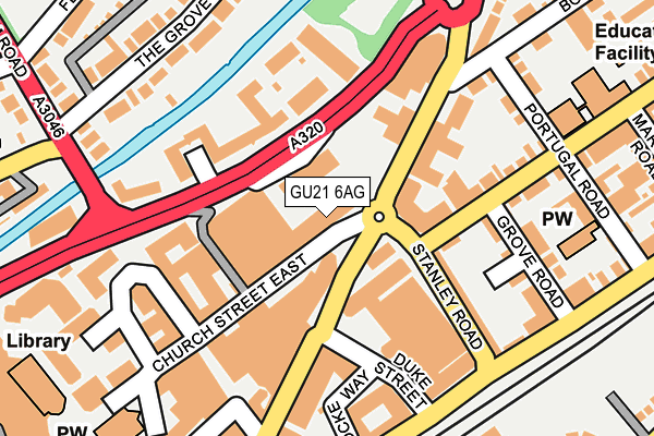
GU21 6AG lies on Church Street East in Woking. GU21 6AG is located in the Canalside electoral ward, within the local authority district of Woking and the English Parliamentary constituency of Woking. The Sub Integrated Care Board (ICB) Location is NHS Surrey Heartlands ICB - 92A and the police force is Surrey. This postcode has been in use since June 2009.


GetTheData
Source: OS OpenMap – Local (Ordnance Survey)
Source: OS VectorMap District (Ordnance Survey)
Licence: Open Government Licence (requires attribution)
| Easting | 500769 |
| Northing | 159052 |
| Latitude | 51.321657 |
| Longitude | -0.555295 |
GetTheData
Source: Open Postcode Geo
Licence: Open Government Licence
| Street | Church Street East |
| Town/City | Woking |
| Country | England |
| Postcode District | GU21 |
➜ See where GU21 is on a map ➜ Where is Woking? | |
GetTheData
Source: Land Registry Price Paid Data
Licence: Open Government Licence
Elevation or altitude of GU21 6AG as distance above sea level:
| Metres | Feet | |
|---|---|---|
| Elevation | 30m | 98ft |
Elevation is measured from the approximate centre of the postcode, to the nearest point on an OS contour line from OS Terrain 50, which has contour spacing of ten vertical metres.
➜ How high above sea level am I? Find the elevation of your current position using your device's GPS.
GetTheData
Source: Open Postcode Elevation
Licence: Open Government Licence
| Ward | Canalside |
| Constituency | Woking |
GetTheData
Source: ONS Postcode Database
Licence: Open Government Licence
| Victoria Way | Woking | 65m |
| Victoria Way | Woking | 92m |
| Board School Road (Chertsey Road) | Woking | 135m |
| Board School Road (Chertsey Road) | Woking | 140m |
| Woking Railway Station (Locke Way) | Woking | 197m |
| Woking Station | 0.4km |
| West Byfleet Station | 4km |
| Worplesdon Station | 4.1km |
GetTheData
Source: NaPTAN
Licence: Open Government Licence
| Percentage of properties with Next Generation Access | 100.0% |
| Percentage of properties with Superfast Broadband | 100.0% |
| Percentage of properties with Ultrafast Broadband | 100.0% |
| Percentage of properties with Full Fibre Broadband | 100.0% |
Superfast Broadband is between 30Mbps and 300Mbps
Ultrafast Broadband is > 300Mbps
| Median download speed | 19.6Mbps |
| Average download speed | 20.5Mbps |
| Maximum download speed | 78.12Mbps |
| Median upload speed | 1.1Mbps |
| Average upload speed | 1.9Mbps |
| Maximum upload speed | 19.53Mbps |
| Percentage of properties unable to receive 2Mbps | 0.0% |
| Percentage of properties unable to receive 5Mbps | 0.0% |
| Percentage of properties unable to receive 10Mbps | 0.0% |
| Percentage of properties unable to receive 30Mbps | 0.0% |
GetTheData
Source: Ofcom
Licence: Ofcom Terms of Use (requires attribution)
GetTheData
Source: ONS Postcode Database
Licence: Open Government Licence


➜ Get more ratings from the Food Standards Agency
GetTheData
Source: Food Standards Agency
Licence: FSA terms & conditions
| Last Collection | |||
|---|---|---|---|
| Location | Mon-Fri | Sat | Distance |
| Chobham Road | 18:45 | 12:30 | 165m |
| Chertsey Road | 18:45 | 12:00 | 176m |
| Crown Square | 18:45 | 08:00 | 182m |
GetTheData
Source: Dracos
Licence: Creative Commons Attribution-ShareAlike
The below table lists the International Territorial Level (ITL) codes (formerly Nomenclature of Territorial Units for Statistics (NUTS) codes) and Local Administrative Units (LAU) codes for GU21 6AG:
| ITL 1 Code | Name |
|---|---|
| TLJ | South East (England) |
| ITL 2 Code | Name |
| TLJ2 | Surrey, East and West Sussex |
| ITL 3 Code | Name |
| TLJ25 | West Surrey |
| LAU 1 Code | Name |
| E07000217 | Woking |
GetTheData
Source: ONS Postcode Directory
Licence: Open Government Licence
The below table lists the Census Output Area (OA), Lower Layer Super Output Area (LSOA), and Middle Layer Super Output Area (MSOA) for GU21 6AG:
| Code | Name | |
|---|---|---|
| OA | E00157805 | |
| LSOA | E01030954 | Woking 008A |
| MSOA | E02006463 | Woking 008 |
GetTheData
Source: ONS Postcode Directory
Licence: Open Government Licence
| GU21 6AD | Church Street East | 0m |
| GU21 5BL | Chertsey Road | 74m |
| GU21 5EW | Stanley Road | 95m |
| GU21 5BJ | Chertsey Road | 104m |
| GU21 6DR | Century Court | 106m |
| GU21 6AJ | Victoria Way | 145m |
| GU21 6AW | Victoria Way | 149m |
| GU21 5DJ | Grosvenor Place | 150m |
| GU21 6HR | Crown Square | 156m |
| GU21 6AN | Victoria Way | 158m |
GetTheData
Source: Open Postcode Geo; Land Registry Price Paid Data
Licence: Open Government Licence