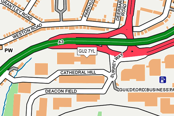
GU2 7YL is located in the Westborough electoral ward, within the local authority district of Guildford and the English Parliamentary constituency of Guildford. The Sub Integrated Care Board (ICB) Location is NHS Surrey Heartlands ICB - 92A and the police force is Surrey. This postcode has been in use since June 2001.


GetTheData
Source: OS OpenMap – Local (Ordnance Survey)
Source: OS VectorMap District (Ordnance Survey)
Licence: Open Government Licence (requires attribution)
| Easting | 498490 |
| Northing | 150712 |
| Latitude | 51.247083 |
| Longitude | -0.590266 |
GetTheData
Source: Open Postcode Geo
Licence: Open Government Licence
| Country | England |
| Postcode District | GU2 |
➜ See where GU2 is on a map ➜ Where is Guildford? | |
GetTheData
Source: Land Registry Price Paid Data
Licence: Open Government Licence
Elevation or altitude of GU2 7YL as distance above sea level:
| Metres | Feet | |
|---|---|---|
| Elevation | 40m | 131ft |
Elevation is measured from the approximate centre of the postcode, to the nearest point on an OS contour line from OS Terrain 50, which has contour spacing of ten vertical metres.
➜ How high above sea level am I? Find the elevation of your current position using your device's GPS.
GetTheData
Source: Open Postcode Elevation
Licence: Open Government Licence
| Ward | Westborough |
| Constituency | Guildford |
GetTheData
Source: ONS Postcode Database
Licence: Open Government Licence
| Guildford Business Park (Surrey Way) | Guildford | 80m |
| Woodbridge Hill (Aldershot Road) | Woodbridge Hill | 283m |
| Austin Pearce (University Of Surrey) | Guildford | 300m |
| Austin Pearce (University Of Surrey) | Guildford | 303m |
| Woodbridge Hill (Aldershot Road) | Woodbridge Hill | 312m |
| Guildford Station | 1.3km |
| London Road (Guildford) Station | 1.9km |
| Shalford (Surrey) Station | 4km |
GetTheData
Source: NaPTAN
Licence: Open Government Licence
GetTheData
Source: ONS Postcode Database
Licence: Open Government Licence


➜ Get more ratings from the Food Standards Agency
GetTheData
Source: Food Standards Agency
Licence: FSA terms & conditions
| Last Collection | |||
|---|---|---|---|
| Location | Mon-Fri | Sat | Distance |
| Weston Road | 16:00 | 11:45 | 155m |
| Woodbridge Hill Post Office | 17:30 | 12:15 | 372m |
| University Post Office | 16:30 | 11:45 | 487m |
GetTheData
Source: Dracos
Licence: Creative Commons Attribution-ShareAlike
The below table lists the International Territorial Level (ITL) codes (formerly Nomenclature of Territorial Units for Statistics (NUTS) codes) and Local Administrative Units (LAU) codes for GU2 7YL:
| ITL 1 Code | Name |
|---|---|
| TLJ | South East (England) |
| ITL 2 Code | Name |
| TLJ2 | Surrey, East and West Sussex |
| ITL 3 Code | Name |
| TLJ25 | West Surrey |
| LAU 1 Code | Name |
| E07000209 | Guildford |
GetTheData
Source: ONS Postcode Directory
Licence: Open Government Licence
The below table lists the Census Output Area (OA), Lower Layer Super Output Area (LSOA), and Middle Layer Super Output Area (MSOA) for GU2 7YL:
| Code | Name | |
|---|---|---|
| OA | E00167780 | |
| LSOA | E01030468 | Guildford 015C |
| MSOA | E02006358 | Guildford 015 |
GetTheData
Source: ONS Postcode Directory
Licence: Open Government Licence
| GU2 8AS | Weston Road | 107m |
| GU2 8AW | Weston Road | 134m |
| GU2 8AT | Deerbarn Road | 194m |
| GU2 8AP | Parkhurst Road | 204m |
| GU2 8AN | Weston Road | 237m |
| GU2 8AR | Woodbridge Hill Gardens | 246m |
| GU2 8AX | Caxton Gardens | 261m |
| GU2 8AU | Weston Road | 263m |
| GU2 8BW | Grantley Road | 283m |
| GU2 8BS | Grantley Gardens | 289m |
GetTheData
Source: Open Postcode Geo; Land Registry Price Paid Data
Licence: Open Government Licence