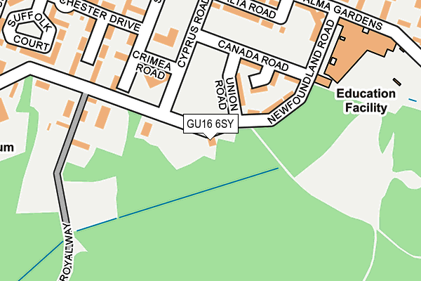
GU16 6SY is located in the Mytchett & Deepcut electoral ward, within the local authority district of Surrey Heath and the English Parliamentary constituency of Surrey Heath. The Sub Integrated Care Board (ICB) Location is NHS Frimley ICB - D4U1Y and the police force is Surrey. This postcode has been in use since January 1980.


GetTheData
Source: OS OpenMap – Local (Ordnance Survey)
Source: OS VectorMap District (Ordnance Survey)
Licence: Open Government Licence (requires attribution)
| Easting | 490788 |
| Northing | 157657 |
| Latitude | 51.310794 |
| Longitude | -0.698823 |
GetTheData
Source: Open Postcode Geo
Licence: Open Government Licence
| Country | England |
| Postcode District | GU16 |
➜ See where GU16 is on a map ➜ Where is Deepcut? | |
GetTheData
Source: Land Registry Price Paid Data
Licence: Open Government Licence
Elevation or altitude of GU16 6SY as distance above sea level:
| Metres | Feet | |
|---|---|---|
| Elevation | 110m | 361ft |
Elevation is measured from the approximate centre of the postcode, to the nearest point on an OS contour line from OS Terrain 50, which has contour spacing of ten vertical metres.
➜ How high above sea level am I? Find the elevation of your current position using your device's GPS.
GetTheData
Source: Open Postcode Elevation
Licence: Open Government Licence
| Ward | Mytchett & Deepcut |
| Constituency | Surrey Heath |
GetTheData
Source: ONS Postcode Database
Licence: Open Government Licence
31, NEWFOUNDLAND ROAD, DEEPCUT, CAMBERLEY, GU16 6SY 2023 31 OCT £555,000 |
49, NEWFOUNDLAND ROAD, DEEPCUT, CAMBERLEY, GU16 6SY 2023 24 OCT £822,500 |
45, NEWFOUNDLAND ROAD, DEEPCUT, CAMBERLEY, GU16 6SY 2023 29 SEP £660,000 |
15, NEWFOUNDLAND ROAD, DEEPCUT, CAMBERLEY, GU16 6SY 2022 14 DEC £610,000 |
13, NEWFOUNDLAND ROAD, DEEPCUT, CAMBERLEY, GU16 6SY 2022 12 DEC £600,000 |
11, NEWFOUNDLAND ROAD, DEEPCUT, CAMBERLEY, GU16 6SY 2022 30 NOV £610,000 |
9, NEWFOUNDLAND ROAD, DEEPCUT, CAMBERLEY, GU16 6SY 2022 30 NOV £610,000 |
17, NEWFOUNDLAND ROAD, DEEPCUT, CAMBERLEY, GU16 6SY 2022 17 OCT £610,000 |
GetTheData
Source: HM Land Registry Price Paid Data
Licence: Contains HM Land Registry data © Crown copyright and database right 2024. This data is licensed under the Open Government Licence v3.0.
| Cyprus Road | Deepcut | 222m |
| Alma Dettingen (Deepcut Bridge Road) | Deepcut | 283m |
| Alma Dettingen (Deepcut Bridge Road) | Deepcut | 290m |
| Garage (Deepcut Bridge Road) | Deepcut | 418m |
| Garage (Deepcut Bridge Road) | Deepcut | 454m |
| Farnborough North Station | 3.2km |
| Frimley Station | 3.4km |
| Camberley Station | 4.3km |
GetTheData
Source: NaPTAN
Licence: Open Government Licence
GetTheData
Source: ONS Postcode Database
Licence: Open Government Licence


➜ Get more ratings from the Food Standards Agency
GetTheData
Source: Food Standards Agency
Licence: FSA terms & conditions
| Last Collection | |||
|---|---|---|---|
| Location | Mon-Fri | Sat | Distance |
| Deepcut Bridge Road | 17:15 | 11:30 | 457m |
| Dettingen Barracks | 17:30 | 11:45 | 846m |
| Cheylesmore Park | 16:45 | 11:45 | 1,324m |
GetTheData
Source: Dracos
Licence: Creative Commons Attribution-ShareAlike
The below table lists the International Territorial Level (ITL) codes (formerly Nomenclature of Territorial Units for Statistics (NUTS) codes) and Local Administrative Units (LAU) codes for GU16 6SY:
| ITL 1 Code | Name |
|---|---|
| TLJ | South East (England) |
| ITL 2 Code | Name |
| TLJ2 | Surrey, East and West Sussex |
| ITL 3 Code | Name |
| TLJ25 | West Surrey |
| LAU 1 Code | Name |
| E07000214 | Surrey Heath |
GetTheData
Source: ONS Postcode Directory
Licence: Open Government Licence
The below table lists the Census Output Area (OA), Lower Layer Super Output Area (LSOA), and Middle Layer Super Output Area (MSOA) for GU16 6SY:
| Code | Name | |
|---|---|---|
| OA | E00167814 | |
| LSOA | E01030784 | Surrey Heath 012C |
| MSOA | E02006427 | Surrey Heath 012 |
GetTheData
Source: ONS Postcode Directory
Licence: Open Government Licence
| GU16 6GQ | Strawberry Court | 76m |
| GU16 6GR | Suffolk Court | 127m |
| GU16 6SL | Deepcut Bridge Road | 134m |
| GU16 6GP | Earl Of Chester Drive | 141m |
| GU16 6GF | Swordsmans Road | 146m |
| GU16 6SQ | Newfoundland Road | 150m |
| GU16 6GA | Brock Close | 204m |
| GU16 6GB | Stickle Down | 291m |
| GU16 6GN | Dettingen Crescent | 294m |
| GU16 6GE | Swordsmans Road | 308m |
GetTheData
Source: Open Postcode Geo; Land Registry Price Paid Data
Licence: Open Government Licence