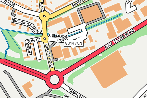
GU14 7QN lies on Eelmoor Road in Farnborough. GU14 7QN is located in the Empress electoral ward, within the local authority district of Rushmoor and the English Parliamentary constituency of Aldershot. The Sub Integrated Care Board (ICB) Location is NHS Frimley ICB - D4U1Y and the police force is Hampshire. This postcode has been in use since January 1980.


GetTheData
Source: OS OpenMap – Local (Ordnance Survey)
Source: OS VectorMap District (Ordnance Survey)
Licence: Open Government Licence (requires attribution)
| Easting | 485938 |
| Northing | 154746 |
| Latitude | 51.285378 |
| Longitude | -0.769089 |
GetTheData
Source: Open Postcode Geo
Licence: Open Government Licence
| Street | Eelmoor Road |
| Town/City | Farnborough |
| Country | England |
| Postcode District | GU14 |
➜ See where GU14 is on a map ➜ Where is Farnborough? | |
GetTheData
Source: Land Registry Price Paid Data
Licence: Open Government Licence
Elevation or altitude of GU14 7QN as distance above sea level:
| Metres | Feet | |
|---|---|---|
| Elevation | 70m | 230ft |
Elevation is measured from the approximate centre of the postcode, to the nearest point on an OS contour line from OS Terrain 50, which has contour spacing of ten vertical metres.
➜ How high above sea level am I? Find the elevation of your current position using your device's GPS.
GetTheData
Source: Open Postcode Elevation
Licence: Open Government Licence
| Ward | Empress |
| Constituency | Aldershot |
GetTheData
Source: ONS Postcode Database
Licence: Open Government Licence
4, EELMOOR ROAD, FARNBOROUGH, GU14 7QN 2003 28 NOV £505,000 |
GetTheData
Source: HM Land Registry Price Paid Data
Licence: Contains HM Land Registry data © Crown copyright and database right 2025. This data is licensed under the Open Government Licence v3.0.
| Cody Road (Marrowbrook Lane) | Farnborough | 153m |
| Cody Road (Marrowbrook Lane) | Farnborough | 162m |
| Fowler Road (Cody Road) | Farnborough | 322m |
| Iq Business Park (Templer Avenue) | North Farnborough | 346m |
| Iq Business Park (Templer Avenue) | North Farnborough | 379m |
| Farnborough (Main) Station | 1.6km |
| Farnborough North Station | 2.6km |
| North Camp Station | 2.9km |
GetTheData
Source: NaPTAN
Licence: Open Government Licence
GetTheData
Source: ONS Postcode Database
Licence: Open Government Licence


➜ Get more ratings from the Food Standards Agency
GetTheData
Source: Food Standards Agency
Licence: FSA terms & conditions
| Last Collection | |||
|---|---|---|---|
| Location | Mon-Fri | Sat | Distance |
| Farnborough Business Park | 18:30 | 242m | |
| Invincible Road | 19:15 | 444m | |
| Farnborough Business Park | 18:30 | 12:00 | 619m |
GetTheData
Source: Dracos
Licence: Creative Commons Attribution-ShareAlike
The below table lists the International Territorial Level (ITL) codes (formerly Nomenclature of Territorial Units for Statistics (NUTS) codes) and Local Administrative Units (LAU) codes for GU14 7QN:
| ITL 1 Code | Name |
|---|---|
| TLJ | South East (England) |
| ITL 2 Code | Name |
| TLJ3 | Hampshire and Isle of Wight |
| ITL 3 Code | Name |
| TLJ37 | North Hampshire |
| LAU 1 Code | Name |
| E07000092 | Rushmoor |
GetTheData
Source: ONS Postcode Directory
Licence: Open Government Licence
The below table lists the Census Output Area (OA), Lower Layer Super Output Area (LSOA), and Middle Layer Super Output Area (MSOA) for GU14 7QN:
| Code | Name | |
|---|---|---|
| OA | E00117351 | |
| LSOA | E01023095 | Rushmoor 006C |
| MSOA | E02004807 | Rushmoor 006 |
GetTheData
Source: ONS Postcode Directory
Licence: Open Government Licence
| GU14 0AD | Marrowbrook Lane | 167m |
| GU14 0DL | Keith Lucas Road | 201m |
| GU14 0DR | Arrow Road | 213m |
| GU14 0DN | Cody Road | 224m |
| GU14 0DG | Keith Lucas Road | 239m |
| GU14 0DF | Cody Road | 264m |
| GU14 0AB | Marrowbrook Lane | 276m |
| GU14 0DU | Brook Gardens | 286m |
| GU14 0DJ | Keith Lucas Road | 287m |
| GU14 0DW | Hazel Avenue | 318m |
GetTheData
Source: Open Postcode Geo; Land Registry Price Paid Data
Licence: Open Government Licence