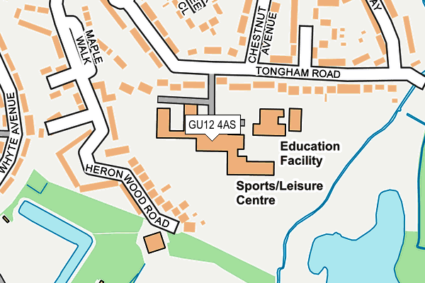
GU12 4AS is located in the Aldershot Park electoral ward, within the local authority district of Rushmoor and the English Parliamentary constituency of Aldershot. The Sub Integrated Care Board (ICB) Location is NHS Frimley ICB - D4U1Y and the police force is Hampshire. This postcode has been in use since January 1980.


GetTheData
Source: OS OpenMap – Local (Ordnance Survey)
Source: OS VectorMap District (Ordnance Survey)
Licence: Open Government Licence (requires attribution)
| Easting | 488036 |
| Northing | 149366 |
| Latitude | 51.236695 |
| Longitude | -0.740353 |
GetTheData
Source: Open Postcode Geo
Licence: Open Government Licence
| Country | England |
| Postcode District | GU12 |
➜ See where GU12 is on a map ➜ Where is Aldershot? | |
GetTheData
Source: Land Registry Price Paid Data
Licence: Open Government Licence
Elevation or altitude of GU12 4AS as distance above sea level:
| Metres | Feet | |
|---|---|---|
| Elevation | 70m | 230ft |
Elevation is measured from the approximate centre of the postcode, to the nearest point on an OS contour line from OS Terrain 50, which has contour spacing of ten vertical metres.
➜ How high above sea level am I? Find the elevation of your current position using your device's GPS.
GetTheData
Source: Open Postcode Elevation
Licence: Open Government Licence
| Ward | Aldershot Park |
| Constituency | Aldershot |
GetTheData
Source: ONS Postcode Database
Licence: Open Government Licence
| Tongham Road (Chestnut Avenue) | Tices Meadow | 182m |
| Allden Avenue (Whyte Avenue) | Tices Meadow | 298m |
| Heronwood Road (Tongham Road) | Tices Meadow | 303m |
| Swimming Pool (Whyte Avenue) | Tices Meadow | 342m |
| Heron Wood Road (Tongham Road) | Tices Meadow | 376m |
| Aldershot Station | 1.7km |
| Ash Station | 2.4km |
| Ash Vale Station | 4.2km |
GetTheData
Source: NaPTAN
Licence: Open Government Licence
GetTheData
Source: ONS Postcode Database
Licence: Open Government Licence


➜ Get more ratings from the Food Standards Agency
GetTheData
Source: Food Standards Agency
Licence: FSA terms & conditions
| Last Collection | |||
|---|---|---|---|
| Location | Mon-Fri | Sat | Distance |
| Manor Road | 16:30 | 07:15 | 751m |
| Oxenden Road | 16:45 | 07:30 | 751m |
| Gloucester Road | 16:30 | 11:15 | 772m |
GetTheData
Source: Dracos
Licence: Creative Commons Attribution-ShareAlike
The below table lists the International Territorial Level (ITL) codes (formerly Nomenclature of Territorial Units for Statistics (NUTS) codes) and Local Administrative Units (LAU) codes for GU12 4AS:
| ITL 1 Code | Name |
|---|---|
| TLJ | South East (England) |
| ITL 2 Code | Name |
| TLJ3 | Hampshire and Isle of Wight |
| ITL 3 Code | Name |
| TLJ37 | North Hampshire |
| LAU 1 Code | Name |
| E07000092 | Rushmoor |
GetTheData
Source: ONS Postcode Directory
Licence: Open Government Licence
The below table lists the Census Output Area (OA), Lower Layer Super Output Area (LSOA), and Middle Layer Super Output Area (MSOA) for GU12 4AS:
| Code | Name | |
|---|---|---|
| OA | E00117420 | |
| LSOA | E01023110 | Rushmoor 012C |
| MSOA | E02004813 | Rushmoor 012 |
GetTheData
Source: ONS Postcode Directory
Licence: Open Government Licence
| GU12 4AR | Tongham Road | 89m |
| GU12 4BH | Heron Wood Road | 128m |
| GU12 4BQ | Heron Wood Road | 148m |
| GU12 4AL | Heron Wood Road | 174m |
| GU12 4BE | Oak Tree Close | 190m |
| GU12 4AP | Tongham Road | 192m |
| GU12 4AU | Chestnut Avenue | 194m |
| GU12 4AX | Hawthorn Close | 198m |
| GU12 4AT | Tongham Road | 212m |
| GU12 4AW | Maple Walk | 215m |
GetTheData
Source: Open Postcode Geo; Land Registry Price Paid Data
Licence: Open Government Licence