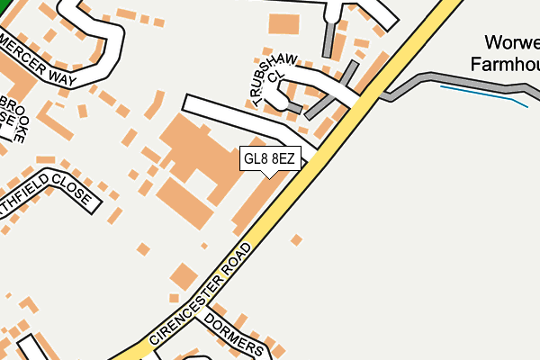
GL8 8EZ is located in the Tetbury East & Rural electoral ward, within the local authority district of Cotswold and the English Parliamentary constituency of The Cotswolds. The Sub Integrated Care Board (ICB) Location is NHS Gloucestershire ICB - 11M and the police force is Gloucestershire. This postcode has been in use since January 1980.


GetTheData
Source: OS OpenMap – Local (Ordnance Survey)
Source: OS VectorMap District (Ordnance Survey)
Licence: Open Government Licence (requires attribution)
| Easting | 389828 |
| Northing | 193843 |
| Latitude | 51.643293 |
| Longitude | -2.148398 |
GetTheData
Source: Open Postcode Geo
Licence: Open Government Licence
| Country | England |
| Postcode District | GL8 |
➜ See where GL8 is on a map ➜ Where is Tetbury? | |
GetTheData
Source: Land Registry Price Paid Data
Licence: Open Government Licence
Elevation or altitude of GL8 8EZ as distance above sea level:
| Metres | Feet | |
|---|---|---|
| Elevation | 120m | 394ft |
Elevation is measured from the approximate centre of the postcode, to the nearest point on an OS contour line from OS Terrain 50, which has contour spacing of ten vertical metres.
➜ How high above sea level am I? Find the elevation of your current position using your device's GPS.
GetTheData
Source: Open Postcode Elevation
Licence: Open Government Licence
| Ward | Tetbury East & Rural |
| Constituency | The Cotswolds |
GetTheData
Source: ONS Postcode Database
Licence: Open Government Licence
| Springfields (Cirencester Road) | Tetbury | 302m |
| Northfield Close (Northfield Road) | Tetbury | 347m |
| Industrial Estate (London Road) | Tetbury | 357m |
| Tesco (London Road) | Tetbury | 468m |
| Tesco (A433) | Tetbury | 552m |
GetTheData
Source: NaPTAN
Licence: Open Government Licence
Estimated total energy consumption in GL8 8EZ by fuel type, 2015.
| Consumption (kWh) | 155,141 |
|---|---|
| Meter count | 12 |
| Mean (kWh/meter) | 12,928 |
| Median (kWh/meter) | 13,234 |
| Consumption (kWh) | 32,059 |
|---|---|
| Meter count | 8 |
| Mean (kWh/meter) | 4,007 |
| Median (kWh/meter) | 3,805 |
GetTheData
Source: Postcode level gas estimates: 2015 (experimental)
Source: Postcode level electricity estimates: 2015 (experimental)
Licence: Open Government Licence
GetTheData
Source: ONS Postcode Database
Licence: Open Government Licence


➜ Get more ratings from the Food Standards Agency
GetTheData
Source: Food Standards Agency
Licence: FSA terms & conditions
| Last Collection | |||
|---|---|---|---|
| Location | Mon-Fri | Sat | Distance |
| Northfield | 17:00 | 11:45 | 441m |
| Conygar Road | 17:00 | 11:45 | 731m |
| Tetbury Post Office | 17:30 | 12:30 | 1,020m |
GetTheData
Source: Dracos
Licence: Creative Commons Attribution-ShareAlike
The below table lists the International Territorial Level (ITL) codes (formerly Nomenclature of Territorial Units for Statistics (NUTS) codes) and Local Administrative Units (LAU) codes for GL8 8EZ:
| ITL 1 Code | Name |
|---|---|
| TLK | South West (England) |
| ITL 2 Code | Name |
| TLK1 | Gloucestershire, Wiltshire and Bath/Bristol area |
| ITL 3 Code | Name |
| TLK13 | Gloucestershire CC |
| LAU 1 Code | Name |
| E07000079 | Cotswold |
GetTheData
Source: ONS Postcode Directory
Licence: Open Government Licence
The below table lists the Census Output Area (OA), Lower Layer Super Output Area (LSOA), and Middle Layer Super Output Area (MSOA) for GL8 8EZ:
| Code | Name | |
|---|---|---|
| OA | E00112936 | |
| LSOA | E01022219 | Cotswold 011E |
| MSOA | E02004625 | Cotswold 011 |
GetTheData
Source: ONS Postcode Directory
Licence: Open Government Licence
| GL8 8HJ | Love Lane | 195m |
| GL8 8HF | Northfield Close | 268m |
| GL8 8FA | Hardie Close | 310m |
| GL8 8GZ | Braybrooke Close | 317m |
| GL8 8GW | London Road | 320m |
| GL8 8EN | Springfields | 335m |
| GL8 8HQ | Northfield Road | 380m |
| GL8 8HH | London Road | 393m |
| GL8 8HA | Cirencester Road | 401m |
| GL8 8JB | Northleaze | 411m |
GetTheData
Source: Open Postcode Geo; Land Registry Price Paid Data
Licence: Open Government Licence