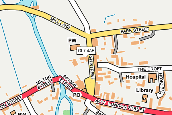
GL7 4AF is located in the Fairford North electoral ward, within the local authority district of Cotswold and the English Parliamentary constituency of The Cotswolds. The Sub Integrated Care Board (ICB) Location is NHS Gloucestershire ICB - 11M and the police force is Gloucestershire. This postcode has been in use since January 1980.


GetTheData
Source: OS OpenMap – Local (Ordnance Survey)
Source: OS VectorMap District (Ordnance Survey)
Licence: Open Government Licence (requires attribution)
| Easting | 415192 |
| Northing | 201133 |
| Latitude | 51.708730 |
| Longitude | -1.781535 |
GetTheData
Source: Open Postcode Geo
Licence: Open Government Licence
| Country | England |
| Postcode District | GL7 |
➜ See where GL7 is on a map ➜ Where is Fairford? | |
GetTheData
Source: Land Registry Price Paid Data
Licence: Open Government Licence
Elevation or altitude of GL7 4AF as distance above sea level:
| Metres | Feet | |
|---|---|---|
| Elevation | 90m | 295ft |
Elevation is measured from the approximate centre of the postcode, to the nearest point on an OS contour line from OS Terrain 50, which has contour spacing of ten vertical metres.
➜ How high above sea level am I? Find the elevation of your current position using your device's GPS.
GetTheData
Source: Open Postcode Elevation
Licence: Open Government Licence
| Ward | Fairford North |
| Constituency | The Cotswolds |
GetTheData
Source: ONS Postcode Database
Licence: Open Government Licence
| Market Place (High Street) | Fairford | 55m |
| Market Place | Fairford | 107m |
| Cricket Field (Park Street) | Fairford | 249m |
| Cricket Field (Park Street) | Fairford | 253m |
| The Vortex Inn (Milton Street) | Fairford | 422m |
GetTheData
Source: NaPTAN
Licence: Open Government Licence
GetTheData
Source: ONS Postcode Database
Licence: Open Government Licence


➜ Get more ratings from the Food Standards Agency
GetTheData
Source: Food Standards Agency
Licence: FSA terms & conditions
| Last Collection | |||
|---|---|---|---|
| Location | Mon-Fri | Sat | Distance |
| Fairford Post Office | 17:15 | 12:00 | 107m |
| Eastleach P.o. | 16:30 | 10:15 | 6,263m |
GetTheData
Source: Dracos
Licence: Creative Commons Attribution-ShareAlike
The below table lists the International Territorial Level (ITL) codes (formerly Nomenclature of Territorial Units for Statistics (NUTS) codes) and Local Administrative Units (LAU) codes for GL7 4AF:
| ITL 1 Code | Name |
|---|---|
| TLK | South West (England) |
| ITL 2 Code | Name |
| TLK1 | Gloucestershire, Wiltshire and Bath/Bristol area |
| ITL 3 Code | Name |
| TLK13 | Gloucestershire CC |
| LAU 1 Code | Name |
| E07000079 | Cotswold |
GetTheData
Source: ONS Postcode Directory
Licence: Open Government Licence
The below table lists the Census Output Area (OA), Lower Layer Super Output Area (LSOA), and Middle Layer Super Output Area (MSOA) for GL7 4AF:
| Code | Name | |
|---|---|---|
| OA | E00112837 | |
| LSOA | E01022203 | Cotswold 009B |
| MSOA | E02004623 | Cotswold 009 |
GetTheData
Source: ONS Postcode Directory
Licence: Open Government Licence
| GL7 4AD | High Street | 35m |
| GL7 4DJ | Croft Lane | 62m |
| GL7 4JL | Park Street | 102m |
| GL7 4AB | Market Place | 110m |
| GL7 4NH | White Hart Court | 136m |
| GL7 4BD | The Croft | 156m |
| GL7 4BJ | Groves Place | 157m |
| GL7 4AQ | London Street | 192m |
| GL7 4JJ | Park Street | 194m |
| GL7 4AH | London Street | 218m |
GetTheData
Source: Open Postcode Geo; Land Registry Price Paid Data
Licence: Open Government Licence