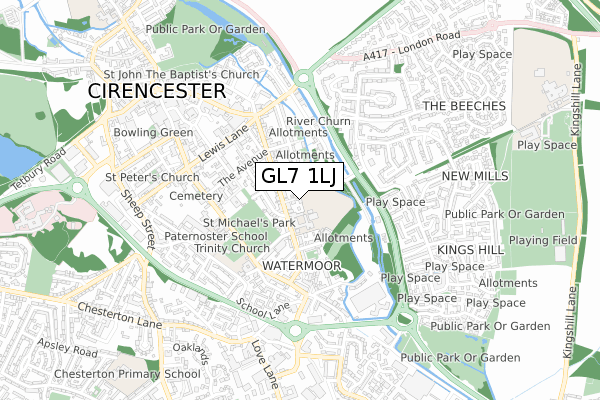
GL7 1LJ is located in the St Michael's electoral ward, within the local authority district of Cotswold and the English Parliamentary constituency of The Cotswolds. The Sub Integrated Care Board (ICB) Location is NHS Gloucestershire ICB - 11M and the police force is Gloucestershire. This postcode has been in use since April 2020.


GetTheData
Source: OS Open Zoomstack (Ordnance Survey)
Licence: Open Government Licence (requires attribution)
Attribution: Contains OS data © Crown copyright and database right 2025
Source: Open Postcode Geo
Licence: Open Government Licence (requires attribution)
Attribution: Contains OS data © Crown copyright and database right 2025; Contains Royal Mail data © Royal Mail copyright and database right 2025; Source: Office for National Statistics licensed under the Open Government Licence v.3.0
| Easting | 402877 |
| Northing | 201574 |
| Latitude | 51.712896 |
| Longitude | -1.959750 |
GetTheData
Source: Open Postcode Geo
Licence: Open Government Licence
| Country | England |
| Postcode District | GL7 |
➜ See where GL7 is on a map ➜ Where is Cirencester? | |
GetTheData
Source: Land Registry Price Paid Data
Licence: Open Government Licence
| Ward | St Michael's |
| Constituency | The Cotswolds |
GetTheData
Source: ONS Postcode Database
Licence: Open Government Licence
| Cirencester Junior School (Victoria Road) | Watermoor | 104m |
| Cirencester Junior School (Victoria Road) | Watermoor | 106m |
| King Street School Stop | Watermoor | 312m |
| Golden Farm Pub (Queen Elizabeth Road) | New Mills | 317m |
| Newcombe Court (Victoria Road) | Cirencester | 317m |
| Kemble Station | 5.9km |
GetTheData
Source: NaPTAN
Licence: Open Government Licence
GetTheData
Source: ONS Postcode Database
Licence: Open Government Licence


➜ Get more ratings from the Food Standards Agency
GetTheData
Source: Food Standards Agency
Licence: FSA terms & conditions
| Last Collection | |||
|---|---|---|---|
| Location | Mon-Fri | Sat | Distance |
| The Avenue | 17:30 | 09:00 | 244m |
| 93 Watermoor Road | 17:15 | 12:00 | 347m |
| Querns Lane | 17:45 | 11:45 | 491m |
GetTheData
Source: Dracos
Licence: Creative Commons Attribution-ShareAlike
The below table lists the International Territorial Level (ITL) codes (formerly Nomenclature of Territorial Units for Statistics (NUTS) codes) and Local Administrative Units (LAU) codes for GL7 1LJ:
| ITL 1 Code | Name |
|---|---|
| TLK | South West (England) |
| ITL 2 Code | Name |
| TLK1 | Gloucestershire, Wiltshire and Bath/Bristol area |
| ITL 3 Code | Name |
| TLK13 | Gloucestershire CC |
| LAU 1 Code | Name |
| E07000079 | Cotswold |
GetTheData
Source: ONS Postcode Directory
Licence: Open Government Licence
The below table lists the Census Output Area (OA), Lower Layer Super Output Area (LSOA), and Middle Layer Super Output Area (MSOA) for GL7 1LJ:
| Code | Name | |
|---|---|---|
| OA | E00112826 | |
| LSOA | E01022199 | Cotswold 007C |
| MSOA | E02004621 | Cotswold 007 |
GetTheData
Source: ONS Postcode Directory
Licence: Open Government Licence
| GL7 1ES | Victoria Road | 66m |
| GL7 1EU | Victoria Road | 124m |
| GL7 1HG | Chester Street | 131m |
| GL7 1HE | Chester Crescent | 186m |
| GL7 1ER | Purley Road | 189m |
| GL7 1EZ | Prospect Place | 207m |
| GL7 1HF | Chester Street | 224m |
| GL7 1EW | Purley Avenue | 226m |
| GL7 1HA | Victoria Road | 239m |
| GL7 1BW | Beeches Road | 269m |
GetTheData
Source: Open Postcode Geo; Land Registry Price Paid Data
Licence: Open Government Licence