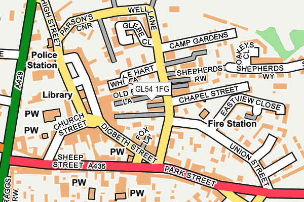
GL54 1FG is located in the Stow electoral ward, within the local authority district of Cotswold and the English Parliamentary constituency of The Cotswolds. The Sub Integrated Care Board (ICB) Location is NHS Gloucestershire ICB - 11M and the police force is Gloucestershire. This postcode has been in use since February 2017.


GetTheData
Source: OS OpenMap – Local (Ordnance Survey)
Source: OS VectorMap District (Ordnance Survey)
Licence: Open Government Licence (requires attribution)
| Easting | 419194 |
| Northing | 226289 |
| Latitude | 51.934792 |
| Longitude | -1.722221 |
GetTheData
Source: Open Postcode Geo
Licence: Open Government Licence
| Country | England |
| Postcode District | GL54 |
➜ See where GL54 is on a map ➜ Where is Stow-on-the-Wold? | |
GetTheData
Source: Land Registry Price Paid Data
Licence: Open Government Licence
| Ward | Stow |
| Constituency | The Cotswolds |
GetTheData
Source: ONS Postcode Database
Licence: Open Government Licence
| Tesco Car Park (Access Road) | Stow-on-the-wold | 153m |
| Police Station (High Street) | Stow-on-the-wold | 386m |
| Police Station (High Street) | Stow-on-the-wold | 398m |
| Coach Stop (Market Square) | Stow-on-the-wold | 474m |
| Library (Market Square) | Stow-on-the-wold | 481m |
GetTheData
Source: NaPTAN
Licence: Open Government Licence
| Percentage of properties with Next Generation Access | 100.0% |
| Percentage of properties with Superfast Broadband | 100.0% |
| Percentage of properties with Ultrafast Broadband | 0.0% |
| Percentage of properties with Full Fibre Broadband | 0.0% |
Superfast Broadband is between 30Mbps and 300Mbps
Ultrafast Broadband is > 300Mbps
| Percentage of properties unable to receive 2Mbps | 0.0% |
| Percentage of properties unable to receive 5Mbps | 0.0% |
| Percentage of properties unable to receive 10Mbps | 0.0% |
| Percentage of properties unable to receive 30Mbps | 0.0% |
GetTheData
Source: Ofcom
Licence: Ofcom Terms of Use (requires attribution)
GetTheData
Source: ONS Postcode Database
Licence: Open Government Licence


➜ Get more ratings from the Food Standards Agency
GetTheData
Source: Food Standards Agency
Licence: FSA terms & conditions
| Last Collection | |||
|---|---|---|---|
| Location | Mon-Fri | Sat | Distance |
| Police Station | 16:45 | 09:30 | 382m |
| Lower Swell | 16:45 | 09:15 | 1,980m |
| Oddington Top | 16:00 | 09:00 | 3,064m |
GetTheData
Source: Dracos
Licence: Creative Commons Attribution-ShareAlike
The below table lists the International Territorial Level (ITL) codes (formerly Nomenclature of Territorial Units for Statistics (NUTS) codes) and Local Administrative Units (LAU) codes for GL54 1FG:
| ITL 1 Code | Name |
|---|---|
| TLK | South West (England) |
| ITL 2 Code | Name |
| TLK1 | Gloucestershire, Wiltshire and Bath/Bristol area |
| ITL 3 Code | Name |
| TLK13 | Gloucestershire CC |
| LAU 1 Code | Name |
| E07000079 | Cotswold |
GetTheData
Source: ONS Postcode Directory
Licence: Open Government Licence
The below table lists the Census Output Area (OA), Lower Layer Super Output Area (LSOA), and Middle Layer Super Output Area (MSOA) for GL54 1FG:
| Code | Name | |
|---|---|---|
| OA | E00112705 | |
| LSOA | E01022177 | Cotswold 002A |
| MSOA | E02004616 | Cotswold 002 |
GetTheData
Source: ONS Postcode Directory
Licence: Open Government Licence
| GL54 1EG | Moreton Road | 123m |
| GL54 1AD | Fosse Folly | 144m |
| GL54 1EH | Fosse Lane | 174m |
| GL54 1EJ | Evesham Road | 218m |
| GL54 1DN | Fosseway | 256m |
| GL54 1HN | Newlands Court | 291m |
| GL54 1EQ | Well Lane | 350m |
| GL54 1DJ | Glebe Close | 369m |
| GL54 1DL | High Street | 371m |
| GL54 1DH | Well Lane | 395m |
GetTheData
Source: Open Postcode Geo; Land Registry Price Paid Data
Licence: Open Government Licence