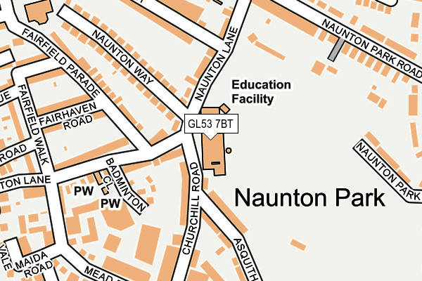
GL53 7BT is located in the College electoral ward, within the local authority district of Cheltenham and the English Parliamentary constituency of Cheltenham. The Sub Integrated Care Board (ICB) Location is NHS Gloucestershire ICB - 11M and the police force is Gloucestershire. This postcode has been in use since January 1980.


GetTheData
Source: OS OpenMap – Local (Ordnance Survey)
Source: OS VectorMap District (Ordnance Survey)
Licence: Open Government Licence (requires attribution)
| Easting | 395043 |
| Northing | 220719 |
| Latitude | 51.885008 |
| Longitude | -2.073426 |
GetTheData
Source: Open Postcode Geo
Licence: Open Government Licence
| Country | England |
| Postcode District | GL53 |
➜ See where GL53 is on a map ➜ Where is Cheltenham? | |
GetTheData
Source: Land Registry Price Paid Data
Licence: Open Government Licence
Elevation or altitude of GL53 7BT as distance above sea level:
| Metres | Feet | |
|---|---|---|
| Elevation | 80m | 262ft |
Elevation is measured from the approximate centre of the postcode, to the nearest point on an OS contour line from OS Terrain 50, which has contour spacing of ten vertical metres.
➜ How high above sea level am I? Find the elevation of your current position using your device's GPS.
GetTheData
Source: Open Postcode Elevation
Licence: Open Government Licence
| Ward | College |
| Constituency | Cheltenham |
GetTheData
Source: ONS Postcode Database
Licence: Open Government Licence
| Croquet Club (Old Bath Road) | Charlton Park | 328m |
| Naunton Park Close (Old Bath Road) | Charlton Park | 337m |
| Croquet Club (Old Bath Road) | Charlton Park | 338m |
| Naunton Park Close (Old Bath Road) | Charlton Park | 341m |
| Fairfield Park Road (Leckhampton Road) | Leckhampton | 426m |
| Cheltenham Spa Station | 2.3km |
GetTheData
Source: NaPTAN
Licence: Open Government Licence
GetTheData
Source: ONS Postcode Database
Licence: Open Government Licence


➜ Get more ratings from the Food Standards Agency
GetTheData
Source: Food Standards Agency
Licence: FSA terms & conditions
| Last Collection | |||
|---|---|---|---|
| Location | Mon-Fri | Sat | Distance |
| Naunton Lane | 17:30 | 12:30 | 83m |
| Naunton Crescent | 17:30 | 12:30 | 230m |
| Old Bath Road | 17:45 | 12:30 | 308m |
GetTheData
Source: Dracos
Licence: Creative Commons Attribution-ShareAlike
The below table lists the International Territorial Level (ITL) codes (formerly Nomenclature of Territorial Units for Statistics (NUTS) codes) and Local Administrative Units (LAU) codes for GL53 7BT:
| ITL 1 Code | Name |
|---|---|
| TLK | South West (England) |
| ITL 2 Code | Name |
| TLK1 | Gloucestershire, Wiltshire and Bath/Bristol area |
| ITL 3 Code | Name |
| TLK13 | Gloucestershire CC |
| LAU 1 Code | Name |
| E07000078 | Cheltenham |
GetTheData
Source: ONS Postcode Directory
Licence: Open Government Licence
The below table lists the Census Output Area (OA), Lower Layer Super Output Area (LSOA), and Middle Layer Super Output Area (MSOA) for GL53 7BT:
| Code | Name | |
|---|---|---|
| OA | E00112390 | |
| LSOA | E01022118 | Cheltenham 014D |
| MSOA | E02004613 | Cheltenham 014 |
GetTheData
Source: ONS Postcode Directory
Licence: Open Government Licence
| GL53 7EN | Churchill Road | 59m |
| GL53 7BG | Naunton Lane | 104m |
| GL53 7EL | Asquith Road | 107m |
| GL53 7BJ | Naunton Lane | 116m |
| GL53 7BX | Badminton Close | 124m |
| GL53 7EG | Churchill Road | 146m |
| GL53 7BH | Naunton Lane | 150m |
| GL53 7EJ | Asquith Road | 151m |
| GL53 7BA | Naunton Lane | 166m |
| GL53 7BQ | Naunton Way | 177m |
GetTheData
Source: Open Postcode Geo; Land Registry Price Paid Data
Licence: Open Government Licence