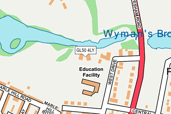
GL50 4LY is located in the Pittville electoral ward, within the local authority district of Cheltenham and the English Parliamentary constituency of Cheltenham. The Sub Integrated Care Board (ICB) Location is NHS Gloucestershire ICB - 11M and the police force is Gloucestershire. This postcode has been in use since March 2017.


GetTheData
Source: OS OpenMap – Local (Ordnance Survey)
Source: OS VectorMap District (Ordnance Survey)
Licence: Open Government Licence (requires attribution)
| Easting | 395180 |
| Northing | 223426 |
| Latitude | 51.909355 |
| Longitude | -2.071467 |
GetTheData
Source: Open Postcode Geo
Licence: Open Government Licence
| Country | England |
| Postcode District | GL50 |
➜ See where GL50 is on a map ➜ Where is Cheltenham? | |
GetTheData
Source: Land Registry Price Paid Data
Licence: Open Government Licence
| Ward | Pittville |
| Constituency | Cheltenham |
GetTheData
Source: ONS Postcode Database
Licence: Open Government Licence
| Pittville Park (Evesham Road) | Cheltenham | 203m |
| Pittville Park (Evesham Road) | Cheltenham | 227m |
| Pittville Pump Room (Evesham Road) | Cheltenham | 331m |
| Pittville Pump Room (Evesham Road) | Cheltenham | 353m |
| Wellington Square (Evesham Road) | Cheltenham | 375m |
| Cheltenham Spa Station | 2.3km |
GetTheData
Source: NaPTAN
Licence: Open Government Licence
| Percentage of properties with Next Generation Access | 100.0% |
| Percentage of properties with Superfast Broadband | 100.0% |
| Percentage of properties with Ultrafast Broadband | 0.0% |
| Percentage of properties with Full Fibre Broadband | 0.0% |
Superfast Broadband is between 30Mbps and 300Mbps
Ultrafast Broadband is > 300Mbps
| Percentage of properties unable to receive 2Mbps | 0.0% |
| Percentage of properties unable to receive 5Mbps | 0.0% |
| Percentage of properties unable to receive 10Mbps | 0.0% |
| Percentage of properties unable to receive 30Mbps | 0.0% |
GetTheData
Source: Ofcom
Licence: Ofcom Terms of Use (requires attribution)
GetTheData
Source: ONS Postcode Database
Licence: Open Government Licence


➜ Get more ratings from the Food Standards Agency
GetTheData
Source: Food Standards Agency
Licence: FSA terms & conditions
| Last Collection | |||
|---|---|---|---|
| Location | Mon-Fri | Sat | Distance |
| Wellington Road | 17:45 | 12:00 | 409m |
| Pitville Spa-clvends Ave | 17:45 | 12:15 | 421m |
| Pitville Crescent | 17:45 | 12:30 | 457m |
GetTheData
Source: Dracos
Licence: Creative Commons Attribution-ShareAlike
The below table lists the International Territorial Level (ITL) codes (formerly Nomenclature of Territorial Units for Statistics (NUTS) codes) and Local Administrative Units (LAU) codes for GL50 4LY:
| ITL 1 Code | Name |
|---|---|
| TLK | South West (England) |
| ITL 2 Code | Name |
| TLK1 | Gloucestershire, Wiltshire and Bath/Bristol area |
| ITL 3 Code | Name |
| TLK13 | Gloucestershire CC |
| LAU 1 Code | Name |
| E07000078 | Cheltenham |
GetTheData
Source: ONS Postcode Directory
Licence: Open Government Licence
The below table lists the Census Output Area (OA), Lower Layer Super Output Area (LSOA), and Middle Layer Super Output Area (MSOA) for GL50 4LY:
| Code | Name | |
|---|---|---|
| OA | E00112519 | |
| LSOA | E01022141 | Cheltenham 008E |
| MSOA | E02004607 | Cheltenham 008 |
GetTheData
Source: ONS Postcode Directory
Licence: Open Government Licence
| GL50 4LB | West Drive | 134m |
| GL52 2AN | Evesham Road | 142m |
| GL50 4LZ | Wellesley Mews | 172m |
| GL52 2AL | Evesham Road | 175m |
| GL50 4AB | Wellington Square | 212m |
| GL50 4LF | Marle Hill Road | 217m |
| GL50 4JX | Wellington Square | 217m |
| GL50 4LE | Marle Hill Road | 239m |
| GL50 4PJ | Albemarle Gate | 242m |
| GL52 2AH | Evesham Road | 272m |
GetTheData
Source: Open Postcode Geo; Land Registry Price Paid Data
Licence: Open Government Licence