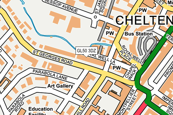
GL50 3DZ lies on St Georges Road in Cheltenham. GL50 3DZ is located in the Lansdown electoral ward, within the local authority district of Cheltenham and the English Parliamentary constituency of Cheltenham. The Sub Integrated Care Board (ICB) Location is NHS Gloucestershire ICB - 11M and the police force is Gloucestershire. This postcode has been in use since December 2020.


GetTheData
Source: OS OpenMap – Local (Ordnance Survey)
Source: OS VectorMap District (Ordnance Survey)
Licence: Open Government Licence (requires attribution)
| Easting | 394483 |
| Northing | 222310 |
| Latitude | 51.899314 |
| Longitude | -2.081581 |
GetTheData
Source: Open Postcode Geo
Licence: Open Government Licence
| Street | St Georges Road |
| Town/City | Cheltenham |
| Country | England |
| Postcode District | GL50 |
➜ See where GL50 is on a map ➜ Where is Cheltenham? | |
GetTheData
Source: Land Registry Price Paid Data
Licence: Open Government Licence
Elevation or altitude of GL50 3DZ as distance above sea level:
| Metres | Feet | |
|---|---|---|
| Elevation | 60m | 197ft |
Elevation is measured from the approximate centre of the postcode, to the nearest point on an OS contour line from OS Terrain 50, which has contour spacing of ten vertical metres.
➜ How high above sea level am I? Find the elevation of your current position using your device's GPS.
GetTheData
Source: Open Postcode Elevation
Licence: Open Government Licence
| Ward | Lansdown |
| Constituency | Cheltenham |
GetTheData
Source: ONS Postcode Database
Licence: Open Government Licence
41 - 49, ST GEORGES ROAD, CHELTENHAM, GL50 3DZ 1999 10 SEP £1,318,000 |
GetTheData
Source: HM Land Registry Price Paid Data
Licence: Contains HM Land Registry data © Crown copyright and database right 2025. This data is licensed under the Open Government Licence v3.0.
| George Hotel (St George's Road) | Cheltenham | 40m |
| Royal Well Lane (St George's Place) | Cheltenham | 82m |
| Chapel Walk Set Down Only (St George's Road) | Cheltenham | 172m |
| St James's House (St James' Square) | Cheltenham | 202m |
| St James's House (St James Square) | Cheltenham | 216m |
| Cheltenham Spa Station | 1.3km |
GetTheData
Source: NaPTAN
Licence: Open Government Licence
GetTheData
Source: ONS Postcode Database
Licence: Open Government Licence


➜ Get more ratings from the Food Standards Agency
GetTheData
Source: Food Standards Agency
Licence: FSA terms & conditions
| Last Collection | |||
|---|---|---|---|
| Location | Mon-Fri | Sat | Distance |
| Bayshill Road | 17:30 | 13:00 | 152m |
| St Georges Road | 17:30 | 13:00 | 186m |
| St James Square | 17:45 | 13:00 | 239m |
GetTheData
Source: Dracos
Licence: Creative Commons Attribution-ShareAlike
The below table lists the International Territorial Level (ITL) codes (formerly Nomenclature of Territorial Units for Statistics (NUTS) codes) and Local Administrative Units (LAU) codes for GL50 3DZ:
| ITL 1 Code | Name |
|---|---|
| TLK | South West (England) |
| ITL 2 Code | Name |
| TLK1 | Gloucestershire, Wiltshire and Bath/Bristol area |
| ITL 3 Code | Name |
| TLK13 | Gloucestershire CC |
| LAU 1 Code | Name |
| E07000078 | Cheltenham |
GetTheData
Source: ONS Postcode Directory
Licence: Open Government Licence
The below table lists the Census Output Area (OA), Lower Layer Super Output Area (LSOA), and Middle Layer Super Output Area (MSOA) for GL50 3DZ:
| Code | Name | |
|---|---|---|
| OA | E00112425 | |
| LSOA | E01022127 | Cheltenham 009G |
| MSOA | E02004608 | Cheltenham 009 |
GetTheData
Source: ONS Postcode Directory
Licence: Open Government Licence
| GL50 3DU | St Georges Road | 48m |
| GL50 3ET | Royal Well Lane | 51m |
| GL50 3QE | Little Bayshill Terrace | 52m |
| GL50 3QB | St Georges Place | 74m |
| GL50 3QD | St Georges Place | 103m |
| GL50 3DT | St Georges Road | 113m |
| GL50 3DN | Royal Well Place | 122m |
| GL50 3PU | St James Square | 131m |
| GL50 3PT | St Georges Terrace | 144m |
| GL50 3PQ | St Georges Place | 144m |
GetTheData
Source: Open Postcode Geo; Land Registry Price Paid Data
Licence: Open Government Licence