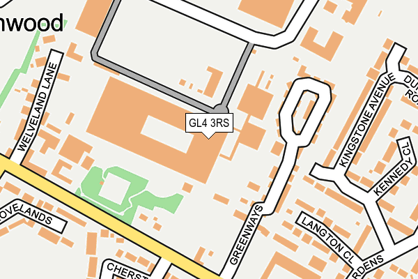
GL4 3RS is located in the Barnwood electoral ward, within the local authority district of Gloucester and the English Parliamentary constituency of Gloucester. The Sub Integrated Care Board (ICB) Location is NHS Gloucestershire ICB - 11M and the police force is Gloucestershire. This postcode has been in use since December 1995.


GetTheData
Source: OS OpenMap – Local (Ordnance Survey)
Source: OS VectorMap District (Ordnance Survey)
Licence: Open Government Licence (requires attribution)
| Easting | 386321 |
| Northing | 218117 |
| Latitude | 51.861466 |
| Longitude | -2.200042 |
GetTheData
Source: Open Postcode Geo
Licence: Open Government Licence
| Country | England |
| Postcode District | GL4 |
➜ See where GL4 is on a map ➜ Where is Gloucester? | |
GetTheData
Source: Land Registry Price Paid Data
Licence: Open Government Licence
Elevation or altitude of GL4 3RS as distance above sea level:
| Metres | Feet | |
|---|---|---|
| Elevation | 30m | 98ft |
Elevation is measured from the approximate centre of the postcode, to the nearest point on an OS contour line from OS Terrain 50, which has contour spacing of ten vertical metres.
➜ How high above sea level am I? Find the elevation of your current position using your device's GPS.
GetTheData
Source: Open Postcode Elevation
Licence: Open Government Licence
| Ward | Barnwood |
| Constituency | Gloucester |
GetTheData
Source: ONS Postcode Database
Licence: Open Government Licence
| British Energy Park & Ride (Barnett Way) | Barnwood | 190m |
| Church Lane (Barnwood Road) | Barnwood | 210m |
| Church Lane (Barnwood Road) | Barnwood | 265m |
| Insley Gardens (Hucclecote Road) | Hucclecote | 331m |
| Barnwood Road School Stop (North Upton Lane) | Barnwood | 334m |
| Gloucester Station | 2.7km |
GetTheData
Source: NaPTAN
Licence: Open Government Licence
GetTheData
Source: ONS Postcode Database
Licence: Open Government Licence


➜ Get more ratings from the Food Standards Agency
GetTheData
Source: Food Standards Agency
Licence: FSA terms & conditions
| Last Collection | |||
|---|---|---|---|
| Location | Mon-Fri | Sat | Distance |
| Barnett Way Business Box | 18:45 | 342m | |
| Insley Gardens Hucclecote | 17:30 | 12:15 | 373m |
| Sainsburys Barnett Way | 18:45 | 12:45 | 440m |
GetTheData
Source: Dracos
Licence: Creative Commons Attribution-ShareAlike
The below table lists the International Territorial Level (ITL) codes (formerly Nomenclature of Territorial Units for Statistics (NUTS) codes) and Local Administrative Units (LAU) codes for GL4 3RS:
| ITL 1 Code | Name |
|---|---|
| TLK | South West (England) |
| ITL 2 Code | Name |
| TLK1 | Gloucestershire, Wiltshire and Bath/Bristol area |
| ITL 3 Code | Name |
| TLK13 | Gloucestershire CC |
| LAU 1 Code | Name |
| E07000081 | Gloucester |
GetTheData
Source: ONS Postcode Directory
Licence: Open Government Licence
The below table lists the Census Output Area (OA), Lower Layer Super Output Area (LSOA), and Middle Layer Super Output Area (MSOA) for GL4 3RS:
| Code | Name | |
|---|---|---|
| OA | E00113275 | |
| LSOA | E01022287 | Gloucester 007G |
| MSOA | E02004642 | Gloucester 007 |
GetTheData
Source: ONS Postcode Directory
Licence: Open Government Licence
| GL4 3SA | Greenways | 102m |
| GL4 3HW | Barnwood Road | 127m |
| GL4 3SD | Greenways | 148m |
| GL3 3AZ | Langton Close | 205m |
| GL3 3AP | Kingstone Avenue | 206m |
| GL3 3AR | Kingstone Avenue | 215m |
| GL4 3HL | Farm Cottages | 230m |
| GL4 3HN | Barnwood Road | 235m |
| GL4 3LE | Cherston Court | 236m |
| GL4 3HS | Barnwood Road | 247m |
GetTheData
Source: Open Postcode Geo; Land Registry Price Paid Data
Licence: Open Government Licence