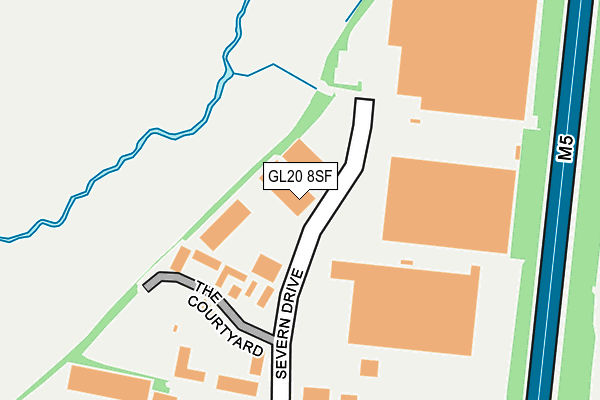
GL20 8SF lies on Severn Drive in Tewkesbury Business Park, Tewkesbury. GL20 8SF is located in the Tewkesbury East electoral ward, within the local authority district of Tewkesbury and the English Parliamentary constituency of Tewkesbury. The Sub Integrated Care Board (ICB) Location is NHS Gloucestershire ICB - 11M and the police force is Gloucestershire. This postcode has been in use since May 2004.


GetTheData
Source: OS OpenMap – Local (Ordnance Survey)
Source: OS VectorMap District (Ordnance Survey)
Licence: Open Government Licence (requires attribution)
| Easting | 391470 |
| Northing | 234246 |
| Latitude | 52.006582 |
| Longitude | -2.125678 |
GetTheData
Source: Open Postcode Geo
Licence: Open Government Licence
| Street | Severn Drive |
| Locality | Tewkesbury Business Park |
| Town/City | Tewkesbury |
| Country | England |
| Postcode District | GL20 |
➜ See where GL20 is on a map ➜ Where is Tewkesbury? | |
GetTheData
Source: Land Registry Price Paid Data
Licence: Open Government Licence
Elevation or altitude of GL20 8SF as distance above sea level:
| Metres | Feet | |
|---|---|---|
| Elevation | 20m | 66ft |
Elevation is measured from the approximate centre of the postcode, to the nearest point on an OS contour line from OS Terrain 50, which has contour spacing of ten vertical metres.
➜ How high above sea level am I? Find the elevation of your current position using your device's GPS.
GetTheData
Source: Open Postcode Elevation
Licence: Open Government Licence
| Ward | Tewkesbury East |
| Constituency | Tewkesbury |
GetTheData
Source: ONS Postcode Database
Licence: Open Government Licence
| Long Eights (The Park) | Northway | 413m |
| Long Eights (The Park) | Northway | 444m |
| The Park School Stop | Northway | 487m |
| The Park School Stop | Northway | 490m |
| Willis Walk (The Park) | Northway | 514m |
| Ashchurch for Tewkesbury Station | 1.4km |
GetTheData
Source: NaPTAN
Licence: Open Government Licence
Estimated total energy consumption in GL20 8SF by fuel type, 2015.
| Consumption (kWh) | 157,616 |
|---|---|
| Meter count | 8 |
| Mean (kWh/meter) | 19,702 |
| Median (kWh/meter) | 16,803 |
GetTheData
Source: Postcode level gas estimates: 2015 (experimental)
Source: Postcode level electricity estimates: 2015 (experimental)
Licence: Open Government Licence
GetTheData
Source: ONS Postcode Database
Licence: Open Government Licence


➜ Get more ratings from the Food Standards Agency
GetTheData
Source: Food Standards Agency
Licence: FSA terms & conditions
| Last Collection | |||
|---|---|---|---|
| Location | Mon-Fri | Sat | Distance |
| Delivery Office, Kennet Close | 18:00 | 12:30 | 315m |
| The Park | 17:15 | 11:30 | 543m |
| Kingston Road | 17:15 | 11:30 | 628m |
GetTheData
Source: Dracos
Licence: Creative Commons Attribution-ShareAlike
The below table lists the International Territorial Level (ITL) codes (formerly Nomenclature of Territorial Units for Statistics (NUTS) codes) and Local Administrative Units (LAU) codes for GL20 8SF:
| ITL 1 Code | Name |
|---|---|
| TLK | South West (England) |
| ITL 2 Code | Name |
| TLK1 | Gloucestershire, Wiltshire and Bath/Bristol area |
| ITL 3 Code | Name |
| TLK13 | Gloucestershire CC |
| LAU 1 Code | Name |
| E07000083 | Tewkesbury |
GetTheData
Source: ONS Postcode Directory
Licence: Open Government Licence
The below table lists the Census Output Area (OA), Lower Layer Super Output Area (LSOA), and Middle Layer Super Output Area (MSOA) for GL20 8SF:
| Code | Name | |
|---|---|---|
| OA | E00114172 | |
| LSOA | E01022455 | Tewkesbury 001E |
| MSOA | E02004666 | Tewkesbury 001 |
GetTheData
Source: ONS Postcode Directory
Licence: Open Government Licence
| GL20 8GD | The Courtyard | 142m |
| GL20 8DN | Severn Drive | 270m |
| GL20 8SL | Shannon Place | 302m |
| GL20 8ST | Tawny Close | 328m |
| GL20 8SZ | Kestrel Way | 331m |
| GL20 8SU | Wagtail Drive | 369m |
| GL20 8SX | Kestrel Way | 371m |
| GL20 8SS | The Park | 387m |
| GL20 8HF | Kennet Close | 392m |
| GL20 8TJ | Curlew Close | 406m |
GetTheData
Source: Open Postcode Geo; Land Registry Price Paid Data
Licence: Open Government Licence