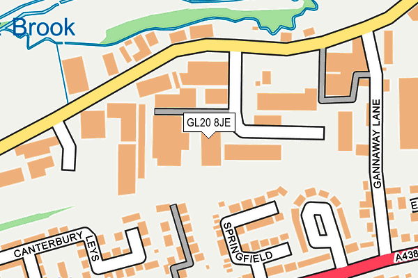
GL20 8JE is located in the Tewkesbury East electoral ward, within the local authority district of Tewkesbury and the English Parliamentary constituency of Tewkesbury. The Sub Integrated Care Board (ICB) Location is NHS Gloucestershire ICB - 11M and the police force is Gloucestershire. This postcode has been in use since January 1980.


GetTheData
Source: OS OpenMap – Local (Ordnance Survey)
Source: OS VectorMap District (Ordnance Survey)
Licence: Open Government Licence (requires attribution)
| Easting | 390699 |
| Northing | 233321 |
| Latitude | 51.998253 |
| Longitude | -2.136884 |
GetTheData
Source: Open Postcode Geo
Licence: Open Government Licence
| Country | England |
| Postcode District | GL20 |
➜ See where GL20 is on a map ➜ Where is Tewkesbury? | |
GetTheData
Source: Land Registry Price Paid Data
Licence: Open Government Licence
Elevation or altitude of GL20 8JE as distance above sea level:
| Metres | Feet | |
|---|---|---|
| Elevation | 20m | 66ft |
Elevation is measured from the approximate centre of the postcode, to the nearest point on an OS contour line from OS Terrain 50, which has contour spacing of ten vertical metres.
➜ How high above sea level am I? Find the elevation of your current position using your device's GPS.
GetTheData
Source: Open Postcode Elevation
Licence: Open Government Licence
| Ward | Tewkesbury East |
| Constituency | Tewkesbury |
GetTheData
Source: ONS Postcode Database
Licence: Open Government Licence
| Springfield (Ashchurch Road) | Newtown | 228m |
| Spa Gardens (Ashchurch Road) | Newtown | 260m |
| Elmbury Drive (Ashchurch Road) | Newtown | 261m |
| Elmbury Drive (Ashchurch Road) | Newtown | 283m |
| Brookside (Meadow Close) | Mitton | 407m |
| Ashchurch for Tewkesbury Station | 1.9km |
GetTheData
Source: NaPTAN
Licence: Open Government Licence
Estimated total energy consumption in GL20 8JE by fuel type, 2015.
| Consumption (kWh) | 135,885 |
|---|---|
| Meter count | 10 |
| Mean (kWh/meter) | 13,589 |
| Median (kWh/meter) | 9,883 |
GetTheData
Source: Postcode level gas estimates: 2015 (experimental)
Source: Postcode level electricity estimates: 2015 (experimental)
Licence: Open Government Licence
GetTheData
Source: ONS Postcode Database
Licence: Open Government Licence


➜ Get more ratings from the Food Standards Agency
GetTheData
Source: Food Standards Agency
Licence: FSA terms & conditions
| Last Collection | |||
|---|---|---|---|
| Location | Mon-Fri | Sat | Distance |
| Ashchurch Road P.o. | 17:15 | 11:30 | 262m |
| Brensham Road | 17:00 | 08:30 | 347m |
| Mitton P.o. | 17:15 | 12:00 | 663m |
GetTheData
Source: Dracos
Licence: Creative Commons Attribution-ShareAlike
The below table lists the International Territorial Level (ITL) codes (formerly Nomenclature of Territorial Units for Statistics (NUTS) codes) and Local Administrative Units (LAU) codes for GL20 8JE:
| ITL 1 Code | Name |
|---|---|
| TLK | South West (England) |
| ITL 2 Code | Name |
| TLK1 | Gloucestershire, Wiltshire and Bath/Bristol area |
| ITL 3 Code | Name |
| TLK13 | Gloucestershire CC |
| LAU 1 Code | Name |
| E07000083 | Tewkesbury |
GetTheData
Source: ONS Postcode Directory
Licence: Open Government Licence
The below table lists the Census Output Area (OA), Lower Layer Super Output Area (LSOA), and Middle Layer Super Output Area (MSOA) for GL20 8JE:
| Code | Name | |
|---|---|---|
| OA | E00114178 | |
| LSOA | E01022455 | Tewkesbury 001E |
| MSOA | E02004666 | Tewkesbury 001 |
GetTheData
Source: ONS Postcode Directory
Licence: Open Government Licence
| GL20 8EP | Springfield | 138m |
| GL20 8BU | Newtown Lane | 167m |
| GL20 8HA | Northway Lane | 183m |
| GL20 8BY | Wellfield | 203m |
| GL20 8BX | Ashchurch Road | 205m |
| GL20 8DA | Gannaway Lane | 245m |
| GL20 8BZ | Ashchurch Road | 259m |
| GL20 8DP | Ashchurch Road | 270m |
| GL20 8DS | Ashchurch Road | 298m |
| GL20 8BP | Canterbury Leys | 305m |
GetTheData
Source: Open Postcode Geo; Land Registry Price Paid Data
Licence: Open Government Licence