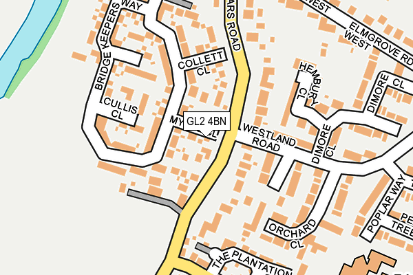
GL2 4BN lies on Mylne Close in Hardwicke, Gloucester. GL2 4BN is located in the Hardwicke electoral ward, within the local authority district of Stroud and the English Parliamentary constituency of Stroud. The Sub Integrated Care Board (ICB) Location is NHS Gloucestershire ICB - 11M and the police force is Gloucestershire. This postcode has been in use since February 2015.


GetTheData
Source: OS OpenMap – Local (Ordnance Survey)
Source: OS VectorMap District (Ordnance Survey)
Licence: Open Government Licence (requires attribution)
| Easting | 379813 |
| Northing | 213186 |
| Latitude | 51.816933 |
| Longitude | -2.294257 |
GetTheData
Source: Open Postcode Geo
Licence: Open Government Licence
| Street | Mylne Close |
| Locality | Hardwicke |
| Town/City | Gloucester |
| Country | England |
| Postcode District | GL2 |
➜ See where GL2 is on a map | |
GetTheData
Source: Land Registry Price Paid Data
Licence: Open Government Licence
Elevation or altitude of GL2 4BN as distance above sea level:
| Metres | Feet | |
|---|---|---|
| Elevation | 10m | 33ft |
Elevation is measured from the approximate centre of the postcode, to the nearest point on an OS contour line from OS Terrain 50, which has contour spacing of ten vertical metres.
➜ How high above sea level am I? Find the elevation of your current position using your device's GPS.
GetTheData
Source: Open Postcode Elevation
Licence: Open Government Licence
| Ward | Hardwicke |
| Constituency | Stroud |
GetTheData
Source: ONS Postcode Database
Licence: Open Government Licence
| Dimore Close (Westland Road) | Hardwicke | 127m |
| Dimore Close | Hardwicke | 143m |
| Elmgrove Road West (Sellars Road) | Hardwicke | 246m |
| Elmgrove Road West (Sellars Road) | Hardwicke | 247m |
| Oak Tree Close | Hardwicke | 248m |
GetTheData
Source: NaPTAN
Licence: Open Government Licence
| Percentage of properties with Next Generation Access | 100.0% |
| Percentage of properties with Superfast Broadband | 100.0% |
| Percentage of properties with Ultrafast Broadband | 0.0% |
| Percentage of properties with Full Fibre Broadband | 0.0% |
Superfast Broadband is between 30Mbps and 300Mbps
Ultrafast Broadband is > 300Mbps
| Median download speed | 41.9Mbps |
| Average download speed | 43.4Mbps |
| Maximum download speed | 59.36Mbps |
| Median upload speed | 10.5Mbps |
| Average upload speed | 11.7Mbps |
| Maximum upload speed | 18.01Mbps |
| Percentage of properties unable to receive 2Mbps | 0.0% |
| Percentage of properties unable to receive 5Mbps | 0.0% |
| Percentage of properties unable to receive 10Mbps | 0.0% |
| Percentage of properties unable to receive 30Mbps | 0.0% |
GetTheData
Source: Ofcom
Licence: Ofcom Terms of Use (requires attribution)
GetTheData
Source: ONS Postcode Database
Licence: Open Government Licence


➜ Get more ratings from the Food Standards Agency
GetTheData
Source: Food Standards Agency
Licence: FSA terms & conditions
| Last Collection | |||
|---|---|---|---|
| Location | Mon-Fri | Sat | Distance |
| Westlands Road Hardwicke | 16:35 | 10:15 | 292m |
| Dales Wharf Quedgeley | 16:30 | 09:15 | 519m |
| Hardwickepo | 16:40 | 09:45 | 610m |
GetTheData
Source: Dracos
Licence: Creative Commons Attribution-ShareAlike
The below table lists the International Territorial Level (ITL) codes (formerly Nomenclature of Territorial Units for Statistics (NUTS) codes) and Local Administrative Units (LAU) codes for GL2 4BN:
| ITL 1 Code | Name |
|---|---|
| TLK | South West (England) |
| ITL 2 Code | Name |
| TLK1 | Gloucestershire, Wiltshire and Bath/Bristol area |
| ITL 3 Code | Name |
| TLK13 | Gloucestershire CC |
| LAU 1 Code | Name |
| E07000082 | Stroud |
GetTheData
Source: ONS Postcode Directory
Licence: Open Government Licence
The below table lists the Census Output Area (OA), Lower Layer Super Output Area (LSOA), and Middle Layer Super Output Area (MSOA) for GL2 4BN:
| Code | Name | |
|---|---|---|
| OA | E00113761 | |
| LSOA | E01022378 | Stroud 001A |
| MSOA | E02004651 | Stroud 001 |
GetTheData
Source: ONS Postcode Directory
Licence: Open Government Licence
| GL2 4BP | Dadford Close | 63m |
| GL2 4QD | Sellars Road | 95m |
| GL2 4BG | Collett Close | 110m |
| GL2 4BQ | Cullis Close | 130m |
| GL2 4XP | Hembury Close | 144m |
| GL2 4BS | Purton Close | 160m |
| GL2 4BE | Bridge Keepers Way | 163m |
| GL2 4QH | Westland Road | 170m |
| GL2 4SZ | Orchard Close | 181m |
| GL2 4BA | Patch Bridge Close | 187m |
GetTheData
Source: Open Postcode Geo; Land Registry Price Paid Data
Licence: Open Government Licence