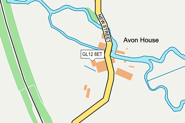
GL12 8ET is located in the Charfield electoral ward, within the unitary authority of South Gloucestershire and the English Parliamentary constituency of Thornbury and Yate. The Sub Integrated Care Board (ICB) Location is NHS Bristol, North Somerset and South Gloucestershire ICB - 15C and the police force is Avon and Somerset. This postcode has been in use since November 2006.


GetTheData
Source: OS OpenMap – Local (Ordnance Survey)
Source: OS VectorMap District (Ordnance Survey)
Licence: Open Government Licence (requires attribution)
| Easting | 372202 |
| Northing | 193001 |
| Latitude | 51.635126 |
| Longitude | -2.403047 |
GetTheData
Source: Open Postcode Geo
Licence: Open Government Licence
| Country | England |
| Postcode District | GL12 |
➜ See where GL12 is on a map | |
GetTheData
Source: Land Registry Price Paid Data
Licence: Open Government Licence
Elevation or altitude of GL12 8ET as distance above sea level:
| Metres | Feet | |
|---|---|---|
| Elevation | 30m | 98ft |
Elevation is measured from the approximate centre of the postcode, to the nearest point on an OS contour line from OS Terrain 50, which has contour spacing of ten vertical metres.
➜ How high above sea level am I? Find the elevation of your current position using your device's GPS.
GetTheData
Source: Open Postcode Elevation
Licence: Open Government Licence
| Ward | Charfield |
| Constituency | Thornbury And Yate |
GetTheData
Source: ONS Postcode Database
Licence: Open Government Licence
| Railway Tavern (Wotton Road) | Charfield | 699m |
| Railway Tavern (Wotton Road) | Charfield | 713m |
| The Limes (Wotton Road) | Charfield | 748m |
| The Limes (Wotton Road) | Charfield | 767m |
| Charfield Primary School (Wotton Road) | Charfield | 883m |
GetTheData
Source: NaPTAN
Licence: Open Government Licence
GetTheData
Source: ONS Postcode Database
Licence: Open Government Licence


➜ Get more ratings from the Food Standards Agency
GetTheData
Source: Food Standards Agency
Licence: FSA terms & conditions
| Last Collection | |||
|---|---|---|---|
| Location | Mon-Fri | Sat | Distance |
| Mill Road Charfield | 17:15 | 07:00 | 114m |
| Wotton Road Charfield | 17:15 | 09:30 | 693m |
| Charfield P.o. | 17:00 | 10:00 | 972m |
GetTheData
Source: Dracos
Licence: Creative Commons Attribution-ShareAlike
| Risk of GL12 8ET flooding from rivers and sea | High |
| ➜ GL12 8ET flood map | |
GetTheData
Source: Open Flood Risk by Postcode
Licence: Open Government Licence
The below table lists the International Territorial Level (ITL) codes (formerly Nomenclature of Territorial Units for Statistics (NUTS) codes) and Local Administrative Units (LAU) codes for GL12 8ET:
| ITL 1 Code | Name |
|---|---|
| TLK | South West (England) |
| ITL 2 Code | Name |
| TLK1 | Gloucestershire, Wiltshire and Bath/Bristol area |
| ITL 3 Code | Name |
| TLK12 | Bath and North East Somerset, North Somerset and South Gloucestershire |
| LAU 1 Code | Name |
| E06000025 | South Gloucestershire |
GetTheData
Source: ONS Postcode Directory
Licence: Open Government Licence
The below table lists the Census Output Area (OA), Lower Layer Super Output Area (LSOA), and Middle Layer Super Output Area (MSOA) for GL12 8ET:
| Code | Name | |
|---|---|---|
| OA | E00075214 | |
| LSOA | E01014885 | South Gloucestershire 003B |
| MSOA | E02003092 | South Gloucestershire 003 |
GetTheData
Source: ONS Postcode Directory
Licence: Open Government Licence
| GL12 8ES | New Street | 363m |
| GL12 8JA | Farm Lees | 377m |
| GL12 8HZ | Longs View | 578m |
| GL12 8HY | 627m | |
| GL12 8SN | Station Close | 723m |
| GL12 8SR | Wotton Road | 734m |
| GL12 8UF | The Sidings | 783m |
| GL12 8TG | Wotton Road | 796m |
| GL12 8TF | Newtown | 797m |
| GL12 8UB | Kings Meadow | 799m |
GetTheData
Source: Open Postcode Geo; Land Registry Price Paid Data
Licence: Open Government Licence