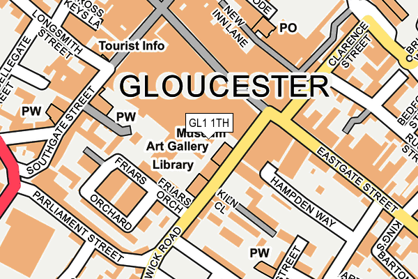
GL1 1TH is located in the Westgate electoral ward, within the local authority district of Gloucester and the English Parliamentary constituency of Gloucester. The Sub Integrated Care Board (ICB) Location is NHS Gloucestershire ICB - 11M and the police force is Gloucestershire. This postcode has been in use since January 1980.


GetTheData
Source: OS OpenMap – Local (Ordnance Survey)
Source: OS VectorMap District (Ordnance Survey)
Licence: Open Government Licence (requires attribution)
| Easting | 383220 |
| Northing | 218350 |
| Latitude | 51.863483 |
| Longitude | -2.245081 |
GetTheData
Source: Open Postcode Geo
Licence: Open Government Licence
| Country | England |
| Postcode District | GL1 |
➜ See where GL1 is on a map ➜ Where is Gloucester? | |
GetTheData
Source: Land Registry Price Paid Data
Licence: Open Government Licence
Elevation or altitude of GL1 1TH as distance above sea level:
| Metres | Feet | |
|---|---|---|
| Elevation | 20m | 66ft |
Elevation is measured from the approximate centre of the postcode, to the nearest point on an OS contour line from OS Terrain 50, which has contour spacing of ten vertical metres.
➜ How high above sea level am I? Find the elevation of your current position using your device's GPS.
GetTheData
Source: Open Postcode Elevation
Licence: Open Government Licence
| Ward | Westgate |
| Constituency | Gloucester |
GetTheData
Source: ONS Postcode Database
Licence: Open Government Licence
| New Look (Brunswick Road) | Gloucester | 76m |
| St Michael's Square (Brunswick Road) | Gloucester | 78m |
| New Look (Brunswick Road) | Gloucester | 80m |
| Boots (Brunswick Road) | Gloucester | 89m |
| St Michael's Square (Brunswick Road) | Gloucester | 95m |
| Gloucester Station | 0.5km |
GetTheData
Source: NaPTAN
Licence: Open Government Licence
GetTheData
Source: ONS Postcode Database
Licence: Open Government Licence


➜ Get more ratings from the Food Standards Agency
GetTheData
Source: Food Standards Agency
Licence: FSA terms & conditions
| Last Collection | |||
|---|---|---|---|
| Location | Mon-Fri | Sat | Distance |
| Southgate Street | 18:30 | 12:30 | 178m |
| Eastgate Street | 18:45 | 12:30 | 196m |
| Kings Square Post Office | 18:45 | 13:00 | 218m |
GetTheData
Source: Dracos
Licence: Creative Commons Attribution-ShareAlike
The below table lists the International Territorial Level (ITL) codes (formerly Nomenclature of Territorial Units for Statistics (NUTS) codes) and Local Administrative Units (LAU) codes for GL1 1TH:
| ITL 1 Code | Name |
|---|---|
| TLK | South West (England) |
| ITL 2 Code | Name |
| TLK1 | Gloucestershire, Wiltshire and Bath/Bristol area |
| ITL 3 Code | Name |
| TLK13 | Gloucestershire CC |
| LAU 1 Code | Name |
| E07000081 | Gloucester |
GetTheData
Source: ONS Postcode Directory
Licence: Open Government Licence
The below table lists the Census Output Area (OA), Lower Layer Super Output Area (LSOA), and Middle Layer Super Output Area (MSOA) for GL1 1TH:
| Code | Name | |
|---|---|---|
| OA | E00113597 | |
| LSOA | E01032937 | Gloucester 004F |
| MSOA | E02004639 | Gloucester 004 |
GetTheData
Source: ONS Postcode Directory
Licence: Open Government Licence
| GL1 1HG | Brunswick Road | 70m |
| GL1 1GG | Kiln Close | 116m |
| GL1 1GH | Kiln Close | 117m |
| GL1 1TT | Priory Place | 120m |
| GL1 1GA | Friars Orchard | 127m |
| GL1 1PA | Eastgate Street | 140m |
| GL1 1HP | Brunswick Road | 148m |
| GL1 1GB | Friars Orchard | 161m |
| GL1 1NS | Eastgate Street | 173m |
| GL1 1DX | Clarence Street | 173m |
GetTheData
Source: Open Postcode Geo; Land Registry Price Paid Data
Licence: Open Government Licence