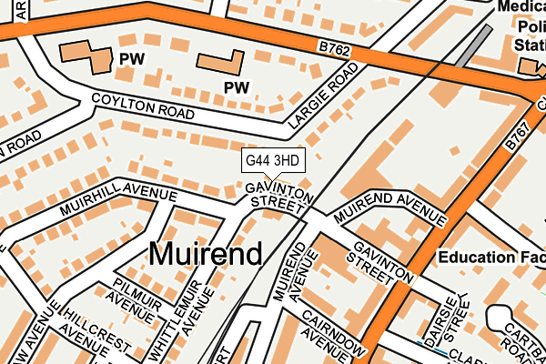
G44 3HD is located in the Newlands/Auldburn electoral ward, within the council area of Glasgow City and the Scottish Parliamentary constituency of Glasgow South. The Community Health Partnership is Glasgow City Community Health & Care Partnership and the police force is Scotland. This postcode has been in use since October 2003.


GetTheData
Source: OS OpenMap – Local (Ordnance Survey)
Source: OS VectorMap District (Ordnance Survey)
Licence: Open Government Licence (requires attribution)
| Easting | 257732 |
| Northing | 660061 |
| Latitude | 55.812789 |
| Longitude | -4.271859 |
GetTheData
Source: Open Postcode Geo
Licence: Open Government Licence
| Country | Scotland |
| Postcode District | G44 |
➜ See where G44 is on a map ➜ Where is Glasgow? | |
GetTheData
Source: Land Registry Price Paid Data
Licence: Open Government Licence
| Ward | Newlands/Auldburn |
| Constituency | Glasgow South |
GetTheData
Source: ONS Postcode Database
Licence: Open Government Licence
| Merrylee Road | Cathcart | 171m |
| Gavinton Street (Clarkston Road) | Muirend | 172m |
| Gavinton Street (Clarkston Road) | Muirend | 192m |
| Merrylee Road | Cathcart | 216m |
| Brunton Street (Clarkston Road) | Cathcart | 232m |
| Muirend Station | 0.4km |
| Cathcart Station | 0.9km |
| Langside Station | 1km |
GetTheData
Source: NaPTAN
Licence: Open Government Licence
| Percentage of properties with Next Generation Access | 100.0% |
| Percentage of properties with Superfast Broadband | 100.0% |
| Percentage of properties with Ultrafast Broadband | 100.0% |
| Percentage of properties with Full Fibre Broadband | 0.0% |
Superfast Broadband is between 30Mbps and 300Mbps
Ultrafast Broadband is > 300Mbps
| Percentage of properties unable to receive 2Mbps | 0.0% |
| Percentage of properties unable to receive 5Mbps | 0.0% |
| Percentage of properties unable to receive 10Mbps | 0.0% |
| Percentage of properties unable to receive 30Mbps | 0.0% |
GetTheData
Source: Ofcom
Licence: Ofcom Terms of Use (requires attribution)
GetTheData
Source: ONS Postcode Database
Licence: Open Government Licence


➜ Get more ratings from the Food Standards Agency
GetTheData
Source: Food Standards Agency
Licence: FSA terms & conditions
| Last Collection | |||
|---|---|---|---|
| Location | Mon-Fri | Sat | Distance |
| Merrylee Road | 17:45 | 12:00 | 181m |
| Clarkston Road | 17:45 | 12:45 | 223m |
| Hillcrest Avenue | 17:45 | 12:45 | 281m |
GetTheData
Source: Dracos
Licence: Creative Commons Attribution-ShareAlike
The below table lists the International Territorial Level (ITL) codes (formerly Nomenclature of Territorial Units for Statistics (NUTS) codes) and Local Administrative Units (LAU) codes for G44 3HD:
| ITL 1 Code | Name |
|---|---|
| TLM | Scotland |
| ITL 2 Code | Name |
| TLM8 | West Central Scotland |
| ITL 3 Code | Name |
| TLM82 | Glasgow City |
| LAU 1 Code | Name |
| S30000052 | Glasgow City |
GetTheData
Source: ONS Postcode Directory
Licence: Open Government Licence
The below table lists the Census Output Area (OA), Lower Layer Super Output Area (LSOA), and Middle Layer Super Output Area (MSOA) for G44 3HD:
| Code | Name | |
|---|---|---|
| OA | S00114951 | |
| LSOA | S01009961 | Muirend and Old Cathcart - 03 |
| MSOA | S02001878 | Muirend and Old Cathcart |
GetTheData
Source: ONS Postcode Directory
Licence: Open Government Licence