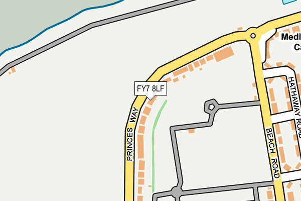
FY7 8LF lies on Princes Way in Fleetwood. FY7 8LF is located in the Warren electoral ward, within the local authority district of Wyre and the English Parliamentary constituency of Lancaster and Fleetwood. The Sub Integrated Care Board (ICB) Location is NHS Lancashire and South Cumbria ICB - 02M and the police force is Lancashire. This postcode has been in use since January 1980.


GetTheData
Source: OS OpenMap – Local (Ordnance Survey)
Source: OS VectorMap District (Ordnance Survey)
Licence: Open Government Licence (requires attribution)
| Easting | 331777 |
| Northing | 447857 |
| Latitude | 53.922337 |
| Longitude | -3.040326 |
GetTheData
Source: Open Postcode Geo
Licence: Open Government Licence
| Street | Princes Way |
| Town/City | Fleetwood |
| Country | England |
| Postcode District | FY7 |
➜ See where FY7 is on a map ➜ Where is Fleetwood? | |
GetTheData
Source: Land Registry Price Paid Data
Licence: Open Government Licence
Elevation or altitude of FY7 8LF as distance above sea level:
| Metres | Feet | |
|---|---|---|
| Elevation | 10m | 33ft |
Elevation is measured from the approximate centre of the postcode, to the nearest point on an OS contour line from OS Terrain 50, which has contour spacing of ten vertical metres.
➜ How high above sea level am I? Find the elevation of your current position using your device's GPS.
GetTheData
Source: Open Postcode Elevation
Licence: Open Government Licence
| Ward | Warren |
| Constituency | Lancaster And Fleetwood |
GetTheData
Source: ONS Postcode Database
Licence: Open Government Licence
| Rossall Point (Laidley's Walk) | Fleetwood | 280m |
| Shakespeare Road (Beach Road) | Fleetwood | 288m |
| Shakespeare Road (Beach Road) | Fleetwood | 299m |
| Rossall Point (Laidleys Walk) | Fleetwood | 342m |
| Beach Road | Fleetwood | 500m |
| Stanley Road (Blackpool Tramway) (Stanley Road) | Freeport | 1,447m |
| Lindel Road (Blackpool Tramway) (Lindel Road) | Freeport | 1,465m |
| Heathfield Road (Blackpool Tramway) (Heathfield Road) | Broadwater | 1,612m |
GetTheData
Source: NaPTAN
Licence: Open Government Licence
| Percentage of properties with Next Generation Access | 100.0% |
| Percentage of properties with Superfast Broadband | 100.0% |
| Percentage of properties with Ultrafast Broadband | 0.0% |
| Percentage of properties with Full Fibre Broadband | 0.0% |
Superfast Broadband is between 30Mbps and 300Mbps
Ultrafast Broadband is > 300Mbps
| Percentage of properties unable to receive 2Mbps | 0.0% |
| Percentage of properties unable to receive 5Mbps | 0.0% |
| Percentage of properties unable to receive 10Mbps | 0.0% |
| Percentage of properties unable to receive 30Mbps | 0.0% |
GetTheData
Source: Ofcom
Licence: Ofcom Terms of Use (requires attribution)
GetTheData
Source: ONS Postcode Database
Licence: Open Government Licence


➜ Get more ratings from the Food Standards Agency
GetTheData
Source: Food Standards Agency
Licence: FSA terms & conditions
| Last Collection | |||
|---|---|---|---|
| Location | Mon-Fri | Sat | Distance |
| Rossall Grange Lane | 17:00 | 12:15 | 537m |
| Manor Road | 17:15 | 12:00 | 580m |
| Broadway P.o. | 18:00 | 11:45 | 731m |
GetTheData
Source: Dracos
Licence: Creative Commons Attribution-ShareAlike
The below table lists the International Territorial Level (ITL) codes (formerly Nomenclature of Territorial Units for Statistics (NUTS) codes) and Local Administrative Units (LAU) codes for FY7 8LF:
| ITL 1 Code | Name |
|---|---|
| TLD | North West (England) |
| ITL 2 Code | Name |
| TLD4 | Lancashire |
| ITL 3 Code | Name |
| TLD44 | Lancaster and Wyre |
| LAU 1 Code | Name |
| E07000128 | Wyre |
GetTheData
Source: ONS Postcode Directory
Licence: Open Government Licence
The below table lists the Census Output Area (OA), Lower Layer Super Output Area (LSOA), and Middle Layer Super Output Area (MSOA) for FY7 8LF:
| Code | Name | |
|---|---|---|
| OA | E00129949 | |
| LSOA | E01025605 | Wyre 002A |
| MSOA | E02005320 | Wyre 002 |
GetTheData
Source: ONS Postcode Directory
Licence: Open Government Licence
| FY7 8PG | Princes Way | 47m |
| FY7 8PQ | Beach Road | 256m |
| FY7 7JH | Hathaway Road | 277m |
| FY7 8AG | West Gate | 281m |
| FY7 8AQ | West Gate | 299m |
| FY7 8PH | Beach Road | 320m |
| FY7 7JE | Avon Green | 352m |
| FY7 8PJ | Beach Road | 363m |
| FY7 7JJ | Mowbray Road | 379m |
| FY7 7JU | Rydal Avenue | 383m |
GetTheData
Source: Open Postcode Geo; Land Registry Price Paid Data
Licence: Open Government Licence