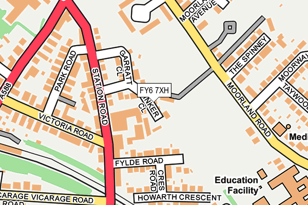
FY6 7XH is located in the Breck electoral ward, within the local authority district of Wyre and the English Parliamentary constituency of Wyre and Preston North. The Sub Integrated Care Board (ICB) Location is NHS Lancashire and South Cumbria ICB - 02M and the police force is Lancashire. This postcode has been in use since February 2017.


GetTheData
Source: OS OpenMap – Local (Ordnance Survey)
Source: OS VectorMap District (Ordnance Survey)
Licence: Open Government Licence (requires attribution)
| Easting | 335232 |
| Northing | 439690 |
| Latitude | 53.849403 |
| Longitude | -2.985990 |
GetTheData
Source: Open Postcode Geo
Licence: Open Government Licence
| Country | England |
| Postcode District | FY6 |
➜ See where FY6 is on a map ➜ Where is Poulton-le-Fylde? | |
GetTheData
Source: Land Registry Price Paid Data
Licence: Open Government Licence
| Ward | Breck |
| Constituency | Wyre And Preston North |
GetTheData
Source: ONS Postcode Database
Licence: Open Government Licence
| Station Road | Poulton-le-fylde | 88m |
| Moorland Road | Little Poulton | 188m |
| Vicarage Road | Poulton-le-fylde | 244m |
| St Johns Rcps (Moorland Road) | Poulton-le-fylde | 253m |
| Moorland Road End (Breck Road) | Poulton-le-fylde | 291m |
| Poulton-le-Fylde Station | 0.3km |
| Layton (Lancs) Station | 3.3km |
| Blackpool North Station | 5.2km |
GetTheData
Source: NaPTAN
Licence: Open Government Licence
| Percentage of properties with Next Generation Access | 100.0% |
| Percentage of properties with Superfast Broadband | 100.0% |
| Percentage of properties with Ultrafast Broadband | 0.0% |
| Percentage of properties with Full Fibre Broadband | 0.0% |
Superfast Broadband is between 30Mbps and 300Mbps
Ultrafast Broadband is > 300Mbps
| Median download speed | 38.7Mbps |
| Average download speed | 32.8Mbps |
| Maximum download speed | 53.33Mbps |
| Median upload speed | 9.7Mbps |
| Average upload speed | 7.6Mbps |
| Maximum upload speed | 11.16Mbps |
| Percentage of properties unable to receive 2Mbps | 0.0% |
| Percentage of properties unable to receive 5Mbps | 0.0% |
| Percentage of properties unable to receive 10Mbps | 0.0% |
| Percentage of properties unable to receive 30Mbps | 0.0% |
GetTheData
Source: Ofcom
Licence: Ofcom Terms of Use (requires attribution)
GetTheData
Source: ONS Postcode Database
Licence: Open Government Licence


➜ Get more ratings from the Food Standards Agency
GetTheData
Source: Food Standards Agency
Licence: FSA terms & conditions
| Last Collection | |||
|---|---|---|---|
| Location | Mon-Fri | Sat | Distance |
| Lockwood Avenue | 17:15 | 12:30 | 348m |
| Lower Green | 17:00 | 11:45 | 504m |
| Breck Drive | 16:00 | 12:30 | 580m |
GetTheData
Source: Dracos
Licence: Creative Commons Attribution-ShareAlike
The below table lists the International Territorial Level (ITL) codes (formerly Nomenclature of Territorial Units for Statistics (NUTS) codes) and Local Administrative Units (LAU) codes for FY6 7XH:
| ITL 1 Code | Name |
|---|---|
| TLD | North West (England) |
| ITL 2 Code | Name |
| TLD4 | Lancashire |
| ITL 3 Code | Name |
| TLD44 | Lancaster and Wyre |
| LAU 1 Code | Name |
| E07000128 | Wyre |
GetTheData
Source: ONS Postcode Directory
Licence: Open Government Licence
The below table lists the Census Output Area (OA), Lower Layer Super Output Area (LSOA), and Middle Layer Super Output Area (MSOA) for FY6 7XH:
| Code | Name | |
|---|---|---|
| OA | E00129629 | |
| LSOA | E01025546 | Wyre 013B |
| MSOA | E02005331 | Wyre 013 |
GetTheData
Source: ONS Postcode Directory
Licence: Open Government Licence
| FY6 7HU | Station Road | 111m |
| FY6 7XD | Station Road | 132m |
| FY6 7HD | Moorland Gardens | 145m |
| FY6 7JE | Fylde Road | 150m |
| FY6 7JF | Crescent Road | 158m |
| FY6 7EQ | Moorland Road | 170m |
| FY6 7JD | Park Road | 182m |
| FY6 7EU | Moorland Road | 182m |
| FY6 7JG | Haworth Crescent | 191m |
| FY6 7JA | Victoria Road | 214m |
GetTheData
Source: Open Postcode Geo; Land Registry Price Paid Data
Licence: Open Government Licence