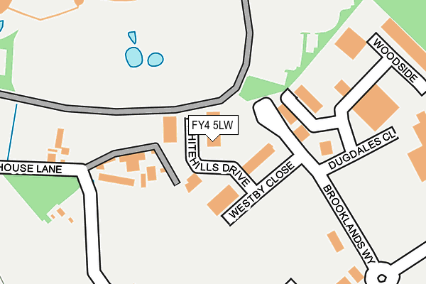
FY4 5LW is located in the Wrea Green with Westby electoral ward, within the local authority district of Fylde and the English Parliamentary constituency of Fylde. The Sub Integrated Care Board (ICB) Location is NHS Lancashire and South Cumbria ICB - 02M and the police force is Lancashire. This postcode has been in use since August 2005.


GetTheData
Source: OS OpenMap – Local (Ordnance Survey)
Source: OS VectorMap District (Ordnance Survey)
Licence: Open Government Licence (requires attribution)
| Easting | 334848 |
| Northing | 433189 |
| Latitude | 53.790918 |
| Longitude | -2.990453 |
GetTheData
Source: Open Postcode Geo
Licence: Open Government Licence
| Country | England |
| Postcode District | FY4 |
➜ See where FY4 is on a map ➜ Where is Blackpool? | |
GetTheData
Source: Land Registry Price Paid Data
Licence: Open Government Licence
Elevation or altitude of FY4 5LW as distance above sea level:
| Metres | Feet | |
|---|---|---|
| Elevation | 10m | 33ft |
Elevation is measured from the approximate centre of the postcode, to the nearest point on an OS contour line from OS Terrain 50, which has contour spacing of ten vertical metres.
➜ How high above sea level am I? Find the elevation of your current position using your device's GPS.
GetTheData
Source: Open Postcode Elevation
Licence: Open Government Licence
| Ward | Wrea Green With Westby |
| Constituency | Fylde |
GetTheData
Source: ONS Postcode Database
Licence: Open Government Licence
| Brooklands Way (Hallam Way) | Peel Hill | 320m |
| Brooklands Way (Hallam Way) | Peel Hill | 324m |
| Dwp Peel Park (Brunel Way) | Peel Park | 456m |
| B&q (Preston New Road) | Peel Hill | 468m |
| Graceways (Lytham St Annes Way) | Peel Hill | 488m |
| Blackpool South Station | 3.9km |
| Blackpool Pleasure Beach Station | 4.2km |
| Squires Gate Station | 4.2km |
GetTheData
Source: NaPTAN
Licence: Open Government Licence
GetTheData
Source: ONS Postcode Database
Licence: Open Government Licence


➜ Get more ratings from the Food Standards Agency
GetTheData
Source: Food Standards Agency
Licence: FSA terms & conditions
| Last Collection | |||
|---|---|---|---|
| Location | Mon-Fri | Sat | Distance |
| Whitehills Business Park | 17:30 | 11:30 | 314m |
| Whitehills Business Park | 17:30 | 12:00 | 316m |
| Fylde Industrial Estate | 17:30 | 12:00 | 620m |
GetTheData
Source: Dracos
Licence: Creative Commons Attribution-ShareAlike
The below table lists the International Territorial Level (ITL) codes (formerly Nomenclature of Territorial Units for Statistics (NUTS) codes) and Local Administrative Units (LAU) codes for FY4 5LW:
| ITL 1 Code | Name |
|---|---|
| TLD | North West (England) |
| ITL 2 Code | Name |
| TLD4 | Lancashire |
| ITL 3 Code | Name |
| TLD45 | Mid Lancashire |
| LAU 1 Code | Name |
| E07000119 | Fylde |
GetTheData
Source: ONS Postcode Directory
Licence: Open Government Licence
The below table lists the Census Output Area (OA), Lower Layer Super Output Area (LSOA), and Middle Layer Super Output Area (MSOA) for FY4 5LW:
| Code | Name | |
|---|---|---|
| OA | E00127047 | |
| LSOA | E01025031 | Fylde 001E |
| MSOA | E02005203 | Fylde 001 |
GetTheData
Source: ONS Postcode Directory
Licence: Open Government Licence
| FY4 5LD | Old House Lane | 97m |
| FY4 5PR | Plumpton Close | 275m |
| FY4 5LU | Hallam Way | 324m |
| FY4 5GU | Olympic Court | 331m |
| FY4 5LZ | Hallam Way | 358m |
| FY4 5PS | Barrow Close | 422m |
| FY4 5PQ | Lytham St Annes Way | 540m |
| FY4 5JP | Peel Hill | 549m |
| FY4 5LB | Cropper Road | 572m |
| FY4 5FQ | Holly Wood Way | 572m |
GetTheData
Source: Open Postcode Geo; Land Registry Price Paid Data
Licence: Open Government Licence