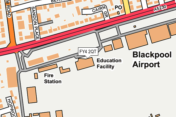
FY4 2QT is located in the Kilgrimol electoral ward, within the local authority district of Fylde and the English Parliamentary constituency of Fylde. The Sub Integrated Care Board (ICB) Location is NHS Lancashire and South Cumbria ICB - 02M and the police force is Lancashire. This postcode has been in use since February 2017.


GetTheData
Source: OS OpenMap – Local (Ordnance Survey)
Source: OS VectorMap District (Ordnance Survey)
Licence: Open Government Licence (requires attribution)
| Easting | 331431 |
| Northing | 431809 |
| Latitude | 53.778092 |
| Longitude | -3.042001 |
GetTheData
Source: Open Postcode Geo
Licence: Open Government Licence
| Country | England |
| Postcode District | FY4 |
➜ See where FY4 is on a map ➜ Where is Blackpool? | |
GetTheData
Source: Land Registry Price Paid Data
Licence: Open Government Licence
| Ward | Kilgrimol |
| Constituency | Fylde |
GetTheData
Source: ONS Postcode Database
Licence: Open Government Licence
| Abbey Road (Squires Gate Lane) | Airport | 201m |
| Abbey Road (Squires Gate Lane) | Squires Gate | 252m |
| Squires Gate (Lytham Road) | Airport | 272m |
| Squires Gate (Lytham Road) | Airport | 272m |
| Blackpool Airport (Squires Gate Lane) | Squires Gate | 302m |
| Starr Gate (Blackpool Tramway) (A584 Clifton Drive) | Squires Gate | 925m |
| Harrow Place (Blackpool Tramway) (Harrow Place) | Squires Gate | 1,164m |
| Burlington Road West (Blackpool Tramway) (Burlington Road West) | South Shore | 1,481m |
| Squires Gate Station | 0.6km |
| Blackpool Pleasure Beach Station | 1.3km |
| Blackpool South Station | 2.3km |
GetTheData
Source: NaPTAN
Licence: Open Government Licence
GetTheData
Source: ONS Postcode Database
Licence: Open Government Licence


➜ Get more ratings from the Food Standards Agency
GetTheData
Source: Food Standards Agency
Licence: FSA terms & conditions
| Last Collection | |||
|---|---|---|---|
| Location | Mon-Fri | Sat | Distance |
| Abbey Road Post Office | 17:30 | 12:00 | 198m |
| Lytham Road South | 16:45 | 12:30 | 286m |
| Squires Gate Airport | 17:00 | 12:30 | 313m |
GetTheData
Source: Dracos
Licence: Creative Commons Attribution-ShareAlike
The below table lists the International Territorial Level (ITL) codes (formerly Nomenclature of Territorial Units for Statistics (NUTS) codes) and Local Administrative Units (LAU) codes for FY4 2QT:
| ITL 1 Code | Name |
|---|---|
| TLD | North West (England) |
| ITL 2 Code | Name |
| TLD4 | Lancashire |
| ITL 3 Code | Name |
| TLD45 | Mid Lancashire |
| LAU 1 Code | Name |
| E07000119 | Fylde |
GetTheData
Source: ONS Postcode Directory
Licence: Open Government Licence
The below table lists the Census Output Area (OA), Lower Layer Super Output Area (LSOA), and Middle Layer Super Output Area (MSOA) for FY4 2QT:
| Code | Name | |
|---|---|---|
| OA | E00127014 | |
| LSOA | E01025024 | Fylde 004D |
| MSOA | E02005206 | Fylde 004 |
GetTheData
Source: ONS Postcode Directory
Licence: Open Government Licence
| FY4 2QQ | Squires Gate Lane | 142m |
| FY4 2BF | Cairn Grove | 156m |
| FY4 2DW | Redwood Close | 165m |
| FY4 2PU | Sandon Place | 205m |
| FY4 2PS | Berwick Road | 215m |
| FY4 2RA | Cairn Grove | 231m |
| FY4 2PT | Berwick Road | 249m |
| FY4 1RG | Lytham Road | 283m |
| FY4 2QE | Priory Gate | 297m |
| FY4 2QD | Byland Close | 302m |
GetTheData
Source: Open Postcode Geo; Land Registry Price Paid Data
Licence: Open Government Licence