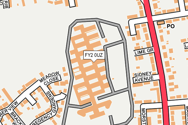
FY2 0UZ is located in the Greenlands electoral ward, within the unitary authority of Blackpool and the English Parliamentary constituency of Blackpool North and Cleveleys. The Sub Integrated Care Board (ICB) Location is NHS Lancashire and South Cumbria ICB - 00R and the police force is Lancashire. This postcode has been in use since January 1980.


GetTheData
Source: OS OpenMap – Local (Ordnance Survey)
Source: OS VectorMap District (Ordnance Survey)
Licence: Open Government Licence (requires attribution)
| Easting | 332030 |
| Northing | 438688 |
| Latitude | 53.839974 |
| Longitude | -3.034437 |
GetTheData
Source: Open Postcode Geo
Licence: Open Government Licence
| Country | England |
| Postcode District | FY2 |
➜ See where FY2 is on a map ➜ Where is Blackpool? | |
GetTheData
Source: Land Registry Price Paid Data
Licence: Open Government Licence
Elevation or altitude of FY2 0UZ as distance above sea level:
| Metres | Feet | |
|---|---|---|
| Elevation | 20m | 66ft |
Elevation is measured from the approximate centre of the postcode, to the nearest point on an OS contour line from OS Terrain 50, which has contour spacing of ten vertical metres.
➜ How high above sea level am I? Find the elevation of your current position using your device's GPS.
GetTheData
Source: Open Postcode Elevation
Licence: Open Government Licence
| Ward | Greenlands |
| Constituency | Blackpool North And Cleveleys |
GetTheData
Source: ONS Postcode Database
Licence: Open Government Licence
| Lime Grove (Bispham Road) | Holyoake | 210m |
| Bispham High School Art College (Bispham High School) | Holyoake | 246m |
| Holyoake Avenue (Bispham Road) | Holyoake | 323m |
| Holyoake Avenue (Bispham Road) | Holyoake | 359m |
| The Squirrel (Bispham Road) | Squirrel | 424m |
| Lowther Avenue (Blackpool Tramway) (Lowther Avenue) | North Shore | 1,329m |
| Cabin (Blackpool Tramway) (Knowle Avenue) | North Shore | 1,356m |
| Cliffs Hotel (Blackpool Tramway) (King Edward Avenue) | North Shore | 1,420m |
| Cavendish Road (Blackpool Tramway) (Cavendish Road) | North Shore | 1,458m |
| Gynn Square (Blackpool Tramway) (Queens Promenade) | Claremont | 1,524m |
| Layton (Lancs) Station | 0.6km |
| Blackpool North Station | 2.2km |
| Poulton-le-Fylde Station | 3km |
GetTheData
Source: NaPTAN
Licence: Open Government Licence
GetTheData
Source: ONS Postcode Database
Licence: Open Government Licence


➜ Get more ratings from the Food Standards Agency
GetTheData
Source: Food Standards Agency
Licence: FSA terms & conditions
| Last Collection | |||
|---|---|---|---|
| Location | Mon-Fri | Sat | Distance |
| Samlesbury Avenue Post Office | 17:30 | 11:30 | 234m |
| 36 Kylemore Avenue | 16:45 | 12:45 | 394m |
| Holyoake Avenue | 17:30 | 11:15 | 471m |
GetTheData
Source: Dracos
Licence: Creative Commons Attribution-ShareAlike
The below table lists the International Territorial Level (ITL) codes (formerly Nomenclature of Territorial Units for Statistics (NUTS) codes) and Local Administrative Units (LAU) codes for FY2 0UZ:
| ITL 1 Code | Name |
|---|---|
| TLD | North West (England) |
| ITL 2 Code | Name |
| TLD4 | Lancashire |
| ITL 3 Code | Name |
| TLD42 | Blackpool |
| LAU 1 Code | Name |
| E06000009 | Blackpool |
GetTheData
Source: ONS Postcode Directory
Licence: Open Government Licence
The below table lists the Census Output Area (OA), Lower Layer Super Output Area (LSOA), and Middle Layer Super Output Area (MSOA) for FY2 0UZ:
| Code | Name | |
|---|---|---|
| OA | E00063976 | |
| LSOA | E01012690 | Blackpool 004A |
| MSOA | E02002636 | Blackpool 004 |
GetTheData
Source: ONS Postcode Directory
Licence: Open Government Licence
| FY2 0WW | Meadow Close | 119m |
| FY2 0WU | Hurstwood Drive | 141m |
| FY2 0NL | Gresley Place | 141m |
| FY2 0NW | Lime Grove | 144m |
| FY2 0NP | Sidney Avenue | 152m |
| FY2 0NJ | Hayfield Avenue | 174m |
| FY2 0NN | Bispham Road | 187m |
| FY2 0WX | Regency Gardens | 193m |
| FY2 0TD | Alston Road | 205m |
| FY2 0WY | Bluebell Close | 224m |
GetTheData
Source: Open Postcode Geo; Land Registry Price Paid Data
Licence: Open Government Licence