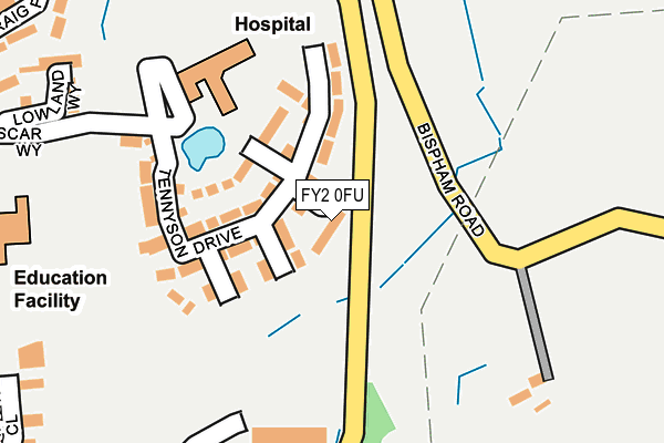
FY2 0FU is located in the Ingthorpe electoral ward, within the unitary authority of Blackpool and the English Parliamentary constituency of Blackpool North and Cleveleys. The Sub Integrated Care Board (ICB) Location is NHS Lancashire and South Cumbria ICB - 00R and the police force is Lancashire. This postcode has been in use since February 2017.


GetTheData
Source: OS OpenMap – Local (Ordnance Survey)
Source: OS VectorMap District (Ordnance Survey)
Licence: Open Government Licence (requires attribution)
| Easting | 331940 |
| Northing | 440510 |
| Latitude | 53.856350 |
| Longitude | -3.036204 |
GetTheData
Source: Open Postcode Geo
Licence: Open Government Licence
| Country | England |
| Postcode District | FY2 |
➜ See where FY2 is on a map ➜ Where is Blackpool? | |
GetTheData
Source: Land Registry Price Paid Data
Licence: Open Government Licence
| Ward | Ingthorpe |
| Constituency | Blackpool North And Cleveleys |
GetTheData
Source: ONS Postcode Database
Licence: Open Government Licence
| Fairfax Avenue (Ashfield Road) | Bispham | 241m |
| Fairfax Avenue (Ashfield Road) | Bispham | 251m |
| Red Lion Hotel (Devonshire Road) | Bispham | 281m |
| Red Lion Hotel | Norbreck | 320m |
| Glenfield Avenue (Ashfield Road) | Bispham | 328m |
| Norbreck (Blackpool Tramway) (Queens Promenade) | Bispham | 929m |
| Sandhurst Avenue (Blackpool Tramway) (Sandhurst Avenue) | Bispham | 1,067m |
| Little Bispham (Blackpool Tramway) (Queens Promenade) | Little Bispham | 1,306m |
| Bispham (Blackpool Tramway) (Red Bank Road) | Bispham | 1,375m |
| Cavendish Road (Blackpool Tramway) (Cavendish Road) | North Shore | 1,579m |
| Layton (Lancs) Station | 2.4km |
| Poulton-le-Fylde Station | 3.1km |
| Blackpool North Station | 3.9km |
GetTheData
Source: NaPTAN
Licence: Open Government Licence
| Percentage of properties with Next Generation Access | 0.0% |
| Percentage of properties with Superfast Broadband | 0.0% |
| Percentage of properties with Ultrafast Broadband | 0.0% |
| Percentage of properties with Full Fibre Broadband | 0.0% |
Superfast Broadband is between 30Mbps and 300Mbps
Ultrafast Broadband is > 300Mbps
| Median download speed | 3.9Mbps |
| Average download speed | 3.5Mbps |
| Maximum download speed | 4.26Mbps |
| Median upload speed | 0.6Mbps |
| Average upload speed | 0.6Mbps |
| Maximum upload speed | 0.97Mbps |
| Percentage of properties unable to receive 2Mbps | 0.0% |
| Percentage of properties unable to receive 5Mbps | 100.0% |
| Percentage of properties unable to receive 10Mbps | 100.0% |
| Percentage of properties unable to receive 30Mbps | 100.0% |
GetTheData
Source: Ofcom
Licence: Ofcom Terms of Use (requires attribution)
GetTheData
Source: ONS Postcode Database
Licence: Open Government Licence


➜ Get more ratings from the Food Standards Agency
GetTheData
Source: Food Standards Agency
Licence: FSA terms & conditions
| Last Collection | |||
|---|---|---|---|
| Location | Mon-Fri | Sat | Distance |
| Ashfield Road Post Office | 17:30 | 11:30 | 260m |
| Crawford Avenue | 17:15 | 12:30 | 361m |
| 9 Portree Road | 17:15 | 12:00 | 485m |
GetTheData
Source: Dracos
Licence: Creative Commons Attribution-ShareAlike
The below table lists the International Territorial Level (ITL) codes (formerly Nomenclature of Territorial Units for Statistics (NUTS) codes) and Local Administrative Units (LAU) codes for FY2 0FU:
| ITL 1 Code | Name |
|---|---|
| TLD | North West (England) |
| ITL 2 Code | Name |
| TLD4 | Lancashire |
| ITL 3 Code | Name |
| TLD42 | Blackpool |
| LAU 1 Code | Name |
| E06000009 | Blackpool |
GetTheData
Source: ONS Postcode Directory
Licence: Open Government Licence
The below table lists the Census Output Area (OA), Lower Layer Super Output Area (LSOA), and Middle Layer Super Output Area (MSOA) for FY2 0FU:
| Code | Name | |
|---|---|---|
| OA | E00064064 | |
| LSOA | E01012703 | Blackpool 002B |
| MSOA | E02002634 | Blackpool 002 |
GetTheData
Source: ONS Postcode Directory
Licence: Open Government Licence
| FY2 0AY | All Hallows Road | 57m |
| FY2 0DA | Fairfax Avenue | 104m |
| FY2 0BZ | Cranbrook Avenue | 120m |
| FY2 0DD | Frinton Grove | 161m |
| FY5 1SF | Fleetwood Road | 167m |
| FY2 0AH | Village Way | 179m |
| FY2 0BY | Fairfax Avenue | 197m |
| FY2 0DB | Glenfield Avenue | 213m |
| FY2 0BU | Ashfield Road | 240m |
| FY2 0DE | Silverdale | 241m |
GetTheData
Source: Open Postcode Geo; Land Registry Price Paid Data
Licence: Open Government Licence