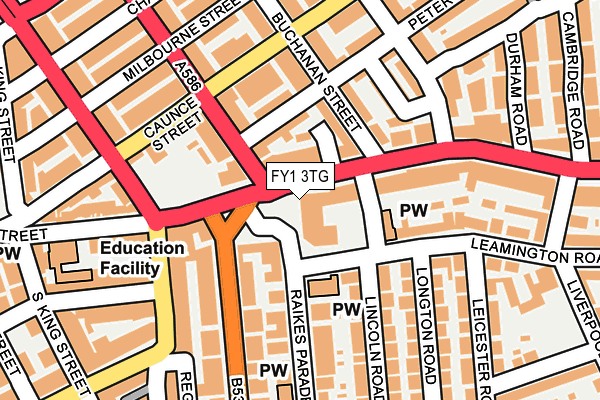
FY1 3TG is located in the Talbot electoral ward, within the unitary authority of Blackpool and the English Parliamentary constituency of Blackpool South. The Sub Integrated Care Board (ICB) Location is NHS Lancashire and South Cumbria ICB - 00R and the police force is Lancashire. This postcode has been in use since August 1993.


GetTheData
Source: OS OpenMap – Local (Ordnance Survey)
Source: OS VectorMap District (Ordnance Survey)
Licence: Open Government Licence (requires attribution)
| Easting | 331360 |
| Northing | 436280 |
| Latitude | 53.818246 |
| Longitude | -3.044079 |
GetTheData
Source: Open Postcode Geo
Licence: Open Government Licence
| Country | England |
| Postcode District | FY1 |
➜ See where FY1 is on a map ➜ Where is Blackpool? | |
GetTheData
Source: Land Registry Price Paid Data
Licence: Open Government Licence
Elevation or altitude of FY1 3TG as distance above sea level:
| Metres | Feet | |
|---|---|---|
| Elevation | 20m | 66ft |
Elevation is measured from the approximate centre of the postcode, to the nearest point on an OS contour line from OS Terrain 50, which has contour spacing of ten vertical metres.
➜ How high above sea level am I? Find the elevation of your current position using your device's GPS.
GetTheData
Source: Open Postcode Elevation
Licence: Open Government Licence
| Ward | Talbot |
| Constituency | Blackpool South |
GetTheData
Source: ONS Postcode Database
Licence: Open Government Licence
| Buchanan Street (Church Street) | Central | 99m |
| Church Street (Park Road) | Central | 108m |
| Buchanan Street (Church Street) | Central | 111m |
| Church Street (Park Road) | Central | 134m |
| Grosvenor Street (Caunce Street) | Central | 142m |
| North Pier (Blackpool Tramway) (Talbot Road) | Blackpool | 780m |
| Tower (Blackpool Tramway) (Promenade) | Blackpool | 876m |
| Central Pier (Blackpool Tramway) (Promenade) | Bloomfield | 1,036m |
| Pleasant Street (Blackpool Tramway) (Pleasant Street) | Claremont | 1,092m |
| Wilton Parade (Blackpool Tramway) (Wilton Parade) | Claremont | 1,305m |
| Blackpool North Station | 0.5km |
| Layton (Lancs) Station | 2.1km |
| Blackpool South Station | 2.2km |
GetTheData
Source: NaPTAN
Licence: Open Government Licence
GetTheData
Source: ONS Postcode Database
Licence: Open Government Licence


➜ Get more ratings from the Food Standards Agency
GetTheData
Source: Food Standards Agency
Licence: FSA terms & conditions
| Last Collection | |||
|---|---|---|---|
| Location | Mon-Fri | Sat | Distance |
| 230 Church Street | 16:15 | 11:15 | 39m |
| 134 Gorton Street | 16:15 | 12:45 | 295m |
| Cannon Cinema | 17:30 | 13:00 | 308m |
GetTheData
Source: Dracos
Licence: Creative Commons Attribution-ShareAlike
The below table lists the International Territorial Level (ITL) codes (formerly Nomenclature of Territorial Units for Statistics (NUTS) codes) and Local Administrative Units (LAU) codes for FY1 3TG:
| ITL 1 Code | Name |
|---|---|
| TLD | North West (England) |
| ITL 2 Code | Name |
| TLD4 | Lancashire |
| ITL 3 Code | Name |
| TLD42 | Blackpool |
| LAU 1 Code | Name |
| E06000009 | Blackpool |
GetTheData
Source: ONS Postcode Directory
Licence: Open Government Licence
The below table lists the Census Output Area (OA), Lower Layer Super Output Area (LSOA), and Middle Layer Super Output Area (MSOA) for FY1 3TG:
| Code | Name | |
|---|---|---|
| OA | E00064233 | |
| LSOA | E01012737 | Blackpool 010E |
| MSOA | E02002642 | Blackpool 010 |
GetTheData
Source: ONS Postcode Directory
Licence: Open Government Licence
| FY1 3PX | Church Street | 40m |
| FY1 3PA | Church Street | 43m |
| FY1 3PT | Church Street | 72m |
| FY1 3LT | Peter Street | 74m |
| FY1 3DX | Grosvenor Street | 97m |
| FY1 3LS | Buchanan Street | 109m |
| FY1 3PZ | Church Street | 126m |
| FY1 4EZ | Leamington Road | 127m |
| FY1 3LY | Lily Street | 143m |
| FY1 3LR | Buchanan Street | 149m |
GetTheData
Source: Open Postcode Geo; Land Registry Price Paid Data
Licence: Open Government Licence