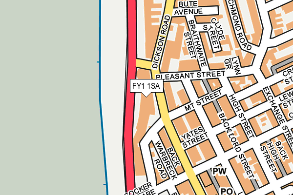
FY1 1SA lies on Promenade in Blackpool. FY1 1SA is located in the Claremont electoral ward, within the unitary authority of Blackpool and the English Parliamentary constituency of Blackpool North and Cleveleys. The Sub Integrated Care Board (ICB) Location is NHS Lancashire and South Cumbria ICB - 00R and the police force is Lancashire. This postcode has been in use since January 1980.


GetTheData
Source: OS OpenMap – Local (Ordnance Survey)
Source: OS VectorMap District (Ordnance Survey)
Licence: Open Government Licence (requires attribution)
| Easting | 330656 |
| Northing | 436992 |
| Latitude | 53.824551 |
| Longitude | -3.054931 |
GetTheData
Source: Open Postcode Geo
Licence: Open Government Licence
| Street | Promenade |
| Town/City | Blackpool |
| Country | England |
| Postcode District | FY1 |
➜ See where FY1 is on a map ➜ Where is Blackpool? | |
GetTheData
Source: Land Registry Price Paid Data
Licence: Open Government Licence
Elevation or altitude of FY1 1SA as distance above sea level:
| Metres | Feet | |
|---|---|---|
| Elevation | 20m | 66ft |
Elevation is measured from the approximate centre of the postcode, to the nearest point on an OS contour line from OS Terrain 50, which has contour spacing of ten vertical metres.
➜ How high above sea level am I? Find the elevation of your current position using your device's GPS.
GetTheData
Source: Open Postcode Elevation
Licence: Open Government Licence
| Ward | Claremont |
| Constituency | Blackpool North And Cleveleys |
GetTheData
Source: ONS Postcode Database
Licence: Open Government Licence
| Mount Street (Dickson Road) | Egerton Square | 32m |
| Pleasant Street (Promenade) | Promenade | 48m |
| Mount Street (Dickson Road) | Egerton Square | 74m |
| Pleasant Street (North Promenade) | Promenade | 102m |
| Imperial Hotel (Dickson Road) | Egerton Square | 111m |
| Pleasant Street (Blackpool Tramway) (Pleasant Street) | Claremont | 96m |
| Wilton Parade (Blackpool Tramway) (Wilton Parade) | Claremont | 362m |
| North Pier (Blackpool Tramway) (Talbot Road) | Blackpool | 656m |
| Gynn Square (Blackpool Tramway) (Queens Promenade) | Claremont | 1,021m |
| Tower (Blackpool Tramway) (Promenade) | Blackpool | 1,109m |
| Blackpool North Station | 0.5km |
| Layton (Lancs) Station | 2km |
| Blackpool South Station | 2.9km |
GetTheData
Source: NaPTAN
Licence: Open Government Licence
GetTheData
Source: ONS Postcode Database
Licence: Open Government Licence


➜ Get more ratings from the Food Standards Agency
GetTheData
Source: Food Standards Agency
Licence: FSA terms & conditions
| Last Collection | |||
|---|---|---|---|
| Location | Mon-Fri | Sat | Distance |
| Pleasant Street | 16:30 | 11:15 | 77m |
| Cocker Square | 16:30 | 12:45 | 182m |
| North Shore Post Office | 17:30 | 11:15 | 248m |
GetTheData
Source: Dracos
Licence: Creative Commons Attribution-ShareAlike
The below table lists the International Territorial Level (ITL) codes (formerly Nomenclature of Territorial Units for Statistics (NUTS) codes) and Local Administrative Units (LAU) codes for FY1 1SA:
| ITL 1 Code | Name |
|---|---|
| TLD | North West (England) |
| ITL 2 Code | Name |
| TLD4 | Lancashire |
| ITL 3 Code | Name |
| TLD42 | Blackpool |
| LAU 1 Code | Name |
| E06000009 | Blackpool |
GetTheData
Source: ONS Postcode Directory
Licence: Open Government Licence
The below table lists the Census Output Area (OA), Lower Layer Super Output Area (LSOA), and Middle Layer Super Output Area (MSOA) for FY1 1SA:
| Code | Name | |
|---|---|---|
| OA | E00063947 | |
| LSOA | E01012681 | Blackpool 006A |
| MSOA | E02002638 | Blackpool 006 |
GetTheData
Source: ONS Postcode Directory
Licence: Open Government Licence
| FY1 2ET | Dickson Road | 48m |
| FY1 2DJ | Lord Street | 72m |
| FY1 1RZ | Promenade | 92m |
| FY1 2DQ | Mount Street | 96m |
| FY1 1SB | Lansdowne Place | 99m |
| FY1 2EU | Dickson Road | 107m |
| FY1 2DG | Lord Street | 112m |
| FY1 1SD | Back Warbreck Road | 114m |
| FY1 2BX | Dickson Road | 114m |
| FY1 1SE | General Street | 115m |
GetTheData
Source: Open Postcode Geo; Land Registry Price Paid Data
Licence: Open Government Licence