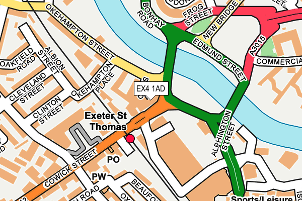
EX4 1AD is located in the St Thomas electoral ward, within the local authority district of Exeter and the English Parliamentary constituency of Exeter. The Sub Integrated Care Board (ICB) Location is NHS Devon ICB - 15N and the police force is Devon & Cornwall. This postcode has been in use since January 1980.


GetTheData
Source: OS OpenMap – Local (Ordnance Survey)
Source: OS VectorMap District (Ordnance Survey)
Licence: Open Government Licence (requires attribution)
| Easting | 291486 |
| Northing | 92050 |
| Latitude | 50.717915 |
| Longitude | -3.538507 |
GetTheData
Source: Open Postcode Geo
Licence: Open Government Licence
| Country | England |
| Postcode District | EX4 |
➜ See where EX4 is on a map ➜ Where is Exeter? | |
GetTheData
Source: Land Registry Price Paid Data
Licence: Open Government Licence
Elevation or altitude of EX4 1AD as distance above sea level:
| Metres | Feet | |
|---|---|---|
| Elevation | 10m | 33ft |
Elevation is measured from the approximate centre of the postcode, to the nearest point on an OS contour line from OS Terrain 50, which has contour spacing of ten vertical metres.
➜ How high above sea level am I? Find the elevation of your current position using your device's GPS.
GetTheData
Source: Open Postcode Elevation
Licence: Open Government Licence
| Ward | St Thomas |
| Constituency | Exeter |
GetTheData
Source: ONS Postcode Database
Licence: Open Government Licence
| Railway Station (Cowick Street) | St Thomas | 68m |
| Precinct (Cowick Street) | St Thomas | 166m |
| Riverside Leisure Centre (Alphington Street) | St Thomas | 175m |
| Malt House (Haven Road) | Haven Banks | 218m |
| The General Buller (Buller Road) | St Thomas | 226m |
| Exeter St Thomas Station | 0.1km |
| Exeter Central Station | 1km |
| Exeter St Davids Station | 1.3km |
GetTheData
Source: NaPTAN
Licence: Open Government Licence
GetTheData
Source: ONS Postcode Database
Licence: Open Government Licence


➜ Get more ratings from the Food Standards Agency
GetTheData
Source: Food Standards Agency
Licence: FSA terms & conditions
| Last Collection | |||
|---|---|---|---|
| Location | Mon-Fri | Sat | Distance |
| St Thomas Post Office | 19:00 | 12:00 | 157m |
| Okehampton Road | 17:00 | 12:00 | 371m |
| Sydney Road Post Office | 19:00 | 12:00 | 440m |
GetTheData
Source: Dracos
Licence: Creative Commons Attribution-ShareAlike
| Risk of EX4 1AD flooding from rivers and sea | Medium |
| ➜ EX4 1AD flood map | |
GetTheData
Source: Open Flood Risk by Postcode
Licence: Open Government Licence
The below table lists the International Territorial Level (ITL) codes (formerly Nomenclature of Territorial Units for Statistics (NUTS) codes) and Local Administrative Units (LAU) codes for EX4 1AD:
| ITL 1 Code | Name |
|---|---|
| TLK | South West (England) |
| ITL 2 Code | Name |
| TLK4 | Devon |
| ITL 3 Code | Name |
| TLK43 | Devon CC |
| LAU 1 Code | Name |
| E07000041 | Exeter |
GetTheData
Source: ONS Postcode Directory
Licence: Open Government Licence
The below table lists the Census Output Area (OA), Lower Layer Super Output Area (LSOA), and Middle Layer Super Output Area (MSOA) for EX4 1AD:
| Code | Name | |
|---|---|---|
| OA | E00101386 | |
| LSOA | E01020030 | Exeter 010C |
| MSOA | E02004158 | Exeter 010 |
GetTheData
Source: ONS Postcode Directory
Licence: Open Government Licence
| EX4 1AG | Cowick Street | 13m |
| EX4 1DU | Okehampton Street | 40m |
| EX4 1AY | Okehampton Place | 102m |
| EX4 1AJ | Cowick Street | 123m |
| EX2 9AT | The Arches | 153m |
| EX4 1AL | Cowick Street | 162m |
| EX2 9AZ | Church Road | 174m |
| EX2 9DP | Church Road | 175m |
| EX4 1DY | Okehampton Street | 191m |
| EX2 8AF | Gervase Avenue | 192m |
GetTheData
Source: Open Postcode Geo; Land Registry Price Paid Data
Licence: Open Government Licence