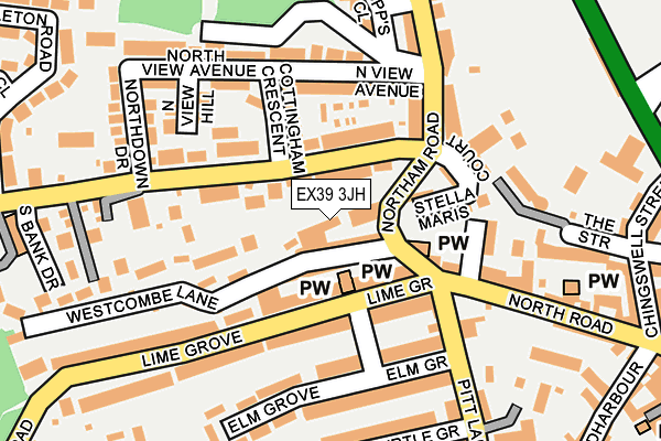
EX39 3JH lies on Westcombe in Bideford. EX39 3JH is located in the Bideford North electoral ward, within the local authority district of Torridge and the English Parliamentary constituency of Torridge and West Devon. The Sub Integrated Care Board (ICB) Location is NHS Devon ICB - 15N and the police force is Devon & Cornwall. This postcode has been in use since January 1980.


GetTheData
Source: OS OpenMap – Local (Ordnance Survey)
Source: OS VectorMap District (Ordnance Survey)
Licence: Open Government Licence (requires attribution)
| Easting | 244982 |
| Northing | 126930 |
| Latitude | 51.020789 |
| Longitude | -4.211602 |
GetTheData
Source: Open Postcode Geo
Licence: Open Government Licence
| Street | Westcombe |
| Town/City | Bideford |
| Country | England |
| Postcode District | EX39 |
➜ See where EX39 is on a map | |
GetTheData
Source: Land Registry Price Paid Data
Licence: Open Government Licence
Elevation or altitude of EX39 3JH as distance above sea level:
| Metres | Feet | |
|---|---|---|
| Elevation | 10m | 33ft |
Elevation is measured from the approximate centre of the postcode, to the nearest point on an OS contour line from OS Terrain 50, which has contour spacing of ten vertical metres.
➜ How high above sea level am I? Find the elevation of your current position using your device's GPS.
GetTheData
Source: Open Postcode Elevation
Licence: Open Government Licence
| Ward | Bideford North |
| Constituency | Torridge And West Devon |
GetTheData
Source: ONS Postcode Database
Licence: Open Government Licence
| Kingsley Road | Orchard Hill | 326m |
| Morrisons | Bideford | 371m |
| Hospital (Abbotsham Road) | Bideford | 377m |
| Kingsley Road | Bideford | 378m |
| Hospital (Abbotsham Road) | Bideford | 384m |
GetTheData
Source: NaPTAN
Licence: Open Government Licence
GetTheData
Source: ONS Postcode Database
Licence: Open Government Licence


➜ Get more ratings from the Food Standards Agency
GetTheData
Source: Food Standards Agency
Licence: FSA terms & conditions
| Last Collection | |||
|---|---|---|---|
| Location | Mon-Fri | Sat | Distance |
| Hunestone Street | 17:45 | 12:00 | 414m |
| Market Place | 18:15 | 12:30 | 512m |
| Bideford Delivery Office | 18:30 | 13:00 | 527m |
GetTheData
Source: Dracos
Licence: Creative Commons Attribution-ShareAlike
| Risk of EX39 3JH flooding from rivers and sea | Low |
| ➜ EX39 3JH flood map | |
GetTheData
Source: Open Flood Risk by Postcode
Licence: Open Government Licence
The below table lists the International Territorial Level (ITL) codes (formerly Nomenclature of Territorial Units for Statistics (NUTS) codes) and Local Administrative Units (LAU) codes for EX39 3JH:
| ITL 1 Code | Name |
|---|---|
| TLK | South West (England) |
| ITL 2 Code | Name |
| TLK4 | Devon |
| ITL 3 Code | Name |
| TLK43 | Devon CC |
| LAU 1 Code | Name |
| E07000046 | Torridge |
GetTheData
Source: ONS Postcode Directory
Licence: Open Government Licence
The below table lists the Census Output Area (OA), Lower Layer Super Output Area (LSOA), and Middle Layer Super Output Area (MSOA) for EX39 3JH:
| Code | Name | |
|---|---|---|
| OA | E00102722 | |
| LSOA | E01020281 | Torridge 003B |
| MSOA | E02004222 | Torridge 003 |
GetTheData
Source: ONS Postcode Directory
Licence: Open Government Licence
| EX39 3LR | South View Terrace | 41m |
| EX39 3JQ | Westcombe Lane | 72m |
| EX39 3LP | Northdown Road | 73m |
| EX39 3JJ | Lime Grove | 99m |
| EX39 3JL | Lime Grove | 102m |
| EX39 3LS | Bellevue Terrace | 105m |
| EX39 2NL | Woodland Terrace | 118m |
| EX39 3LL | Cottingham Crescent | 120m |
| EX39 3LH | North View Avenue | 125m |
| EX39 3JX | Northam Road | 131m |
GetTheData
Source: Open Postcode Geo; Land Registry Price Paid Data
Licence: Open Government Licence