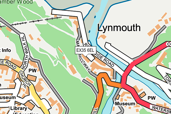
EX35 6EL lies on Lynmouth Street in Lynmouth. EX35 6EL is located in the Lynton & Lynmouth electoral ward, within the local authority district of North Devon and the English Parliamentary constituency of North Devon. The Sub Integrated Care Board (ICB) Location is NHS Devon ICB - 15N and the police force is Devon & Cornwall. This postcode has been in use since January 1980.


GetTheData
Source: OS OpenMap – Local (Ordnance Survey)
Source: OS VectorMap District (Ordnance Survey)
Licence: Open Government Licence (requires attribution)
| Easting | 272253 |
| Northing | 149508 |
| Latitude | 51.230419 |
| Longitude | -3.831019 |
GetTheData
Source: Open Postcode Geo
Licence: Open Government Licence
| Street | Lynmouth Street |
| Town/City | Lynmouth |
| Country | England |
| Postcode District | EX35 |
➜ See where EX35 is on a map ➜ Where is Lynton? | |
GetTheData
Source: Land Registry Price Paid Data
Licence: Open Government Licence
Elevation or altitude of EX35 6EL as distance above sea level:
| Metres | Feet | |
|---|---|---|
| Elevation | 10m | 33ft |
Elevation is measured from the approximate centre of the postcode, to the nearest point on an OS contour line from OS Terrain 50, which has contour spacing of ten vertical metres.
➜ How high above sea level am I? Find the elevation of your current position using your device's GPS.
GetTheData
Source: Open Postcode Elevation
Licence: Open Government Licence
| Ward | Lynton & Lynmouth |
| Constituency | North Devon |
GetTheData
Source: ONS Postcode Database
Licence: Open Government Licence
| Lyndale Bridge (A39) | Lynmouth | 149m |
| Lyndale Bridge (A39) | Lynmouth | 155m |
| Castle Hill Car Park | Lynton | 242m |
| The Studio (Lee Road) | Lynton | 316m |
| Town Hall (Lee Road) | Lynton | 334m |
GetTheData
Source: NaPTAN
Licence: Open Government Licence
GetTheData
Source: ONS Postcode Database
Licence: Open Government Licence


➜ Get more ratings from the Food Standards Agency
GetTheData
Source: Food Standards Agency
Licence: FSA terms & conditions
| Last Collection | |||
|---|---|---|---|
| Location | Mon-Fri | Sat | Distance |
| Lynmouth Post Office | 17:30 | 11:00 | 75m |
| Church Steps | 16:25 | 11:00 | 297m |
| Crown Hotel | 16:20 | 11:00 | 312m |
GetTheData
Source: Dracos
Licence: Creative Commons Attribution-ShareAlike
The below table lists the International Territorial Level (ITL) codes (formerly Nomenclature of Territorial Units for Statistics (NUTS) codes) and Local Administrative Units (LAU) codes for EX35 6EL:
| ITL 1 Code | Name |
|---|---|
| TLK | South West (England) |
| ITL 2 Code | Name |
| TLK4 | Devon |
| ITL 3 Code | Name |
| TLK43 | Devon CC |
| LAU 1 Code | Name |
| E07000043 | North Devon |
GetTheData
Source: ONS Postcode Directory
Licence: Open Government Licence
The below table lists the Census Output Area (OA), Lower Layer Super Output Area (LSOA), and Middle Layer Super Output Area (MSOA) for EX35 6EL:
| Code | Name | |
|---|---|---|
| OA | E00101918 | |
| LSOA | E01020126 | North Devon 002D |
| MSOA | E02004176 | North Devon 002 |
GetTheData
Source: ONS Postcode Directory
Licence: Open Government Licence
| EX35 6EH | Lynmouth Street | 46m |
| EX35 6EF | Mars Hill | 49m |
| EX35 6EX | Riverside Road | 49m |
| EX35 6EE | Clooneavin Path | 62m |
| EX35 6EQ | The Esplanade | 148m |
| EX35 6JA | Castle Hill | 192m |
| EX35 6JD | Castle Heights | 202m |
| EX35 6ES | Summerhouse Path | 217m |
| EX35 6HY | Church Hill | 232m |
| EX35 6EN | 252m |
GetTheData
Source: Open Postcode Geo; Land Registry Price Paid Data
Licence: Open Government Licence