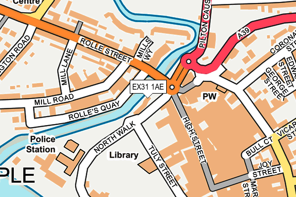
EX31 1AE is located in the Barnstaple Central electoral ward, within the local authority district of North Devon and the English Parliamentary constituency of North Devon. The Sub Integrated Care Board (ICB) Location is NHS Devon ICB - 15N and the police force is Devon & Cornwall. This postcode has been in use since April 2017.


GetTheData
Source: OS OpenMap – Local (Ordnance Survey)
Source: OS VectorMap District (Ordnance Survey)
Licence: Open Government Licence (requires attribution)
| Easting | 255629 |
| Northing | 133490 |
| Latitude | 51.082510 |
| Longitude | -4.062549 |
GetTheData
Source: Open Postcode Geo
Licence: Open Government Licence
| Country | England |
| Postcode District | EX31 |
➜ See where EX31 is on a map ➜ Where is Barnstaple? | |
GetTheData
Source: Land Registry Price Paid Data
Licence: Open Government Licence
| Ward | Barnstaple Central |
| Constituency | North Devon |
GetTheData
Source: ONS Postcode Database
Licence: Open Government Licence
| Mermaid Cross (Mermaid Walk) | Barnstaple | 97m |
| Green Lanes (Boutport Street) | Barnstaple | 204m |
| Green Lanes (Boutport Street) | Barnstaple | 205m |
| Texaco Garage (St George's Road) | Pilton | 328m |
| Texaco Garage (St Georges Road) | Pilton | 329m |
| Barnstaple Station | 1km |
GetTheData
Source: NaPTAN
Licence: Open Government Licence
| Median download speed | 40.0Mbps |
| Average download speed | 51.4Mbps |
| Maximum download speed | 80.00Mbps |
| Median upload speed | 10.0Mbps |
| Average upload speed | 12.4Mbps |
| Maximum upload speed | 20.00Mbps |
GetTheData
Source: Ofcom
Licence: Ofcom Terms of Use (requires attribution)
GetTheData
Source: ONS Postcode Database
Licence: Open Government Licence


➜ Get more ratings from the Food Standards Agency
GetTheData
Source: Food Standards Agency
Licence: FSA terms & conditions
| Last Collection | |||
|---|---|---|---|
| Location | Mon-Fri | Sat | Distance |
| High Street | 18:15 | 12:00 | 63m |
| Green Lanes Shopping Centre | 17:30 | 12:00 | 225m |
| Pilton Bridge | 17:45 | 12:45 | 278m |
GetTheData
Source: Dracos
Licence: Creative Commons Attribution-ShareAlike
| Risk of EX31 1AE flooding from rivers and sea | Low |
| ➜ EX31 1AE flood map | |
GetTheData
Source: Open Flood Risk by Postcode
Licence: Open Government Licence
The below table lists the International Territorial Level (ITL) codes (formerly Nomenclature of Territorial Units for Statistics (NUTS) codes) and Local Administrative Units (LAU) codes for EX31 1AE:
| ITL 1 Code | Name |
|---|---|
| TLK | South West (England) |
| ITL 2 Code | Name |
| TLK4 | Devon |
| ITL 3 Code | Name |
| TLK43 | Devon CC |
| LAU 1 Code | Name |
| E07000043 | North Devon |
GetTheData
Source: ONS Postcode Directory
Licence: Open Government Licence
The below table lists the Census Output Area (OA), Lower Layer Super Output Area (LSOA), and Middle Layer Super Output Area (MSOA) for EX31 1AE:
| Code | Name | |
|---|---|---|
| OA | E00101753 | |
| LSOA | E01020094 | North Devon 008A |
| MSOA | E02004182 | North Devon 008 |
GetTheData
Source: ONS Postcode Directory
Licence: Open Government Licence
| EX31 1JE | Rolle Quay | 77m |
| EX31 1JL | Rolle Cottages | 77m |
| EX31 1GW | Mills Way | 86m |
| EX31 1RH | Boutport Street | 86m |
| EX31 1GX | Mills Way | 101m |
| EX31 1JN | Rolle Street | 139m |
| EX31 1BZ | High Street | 143m |
| EX31 1GY | Mills Way | 146m |
| EX31 1GZ | Mills Way | 153m |
| EX31 1RJ | Boutport Street | 159m |
GetTheData
Source: Open Postcode Geo; Land Registry Price Paid Data
Licence: Open Government Licence