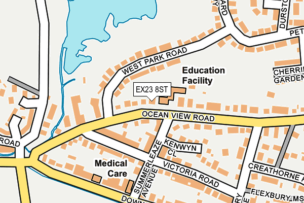
EX23 8ST is located in the Stratton, Kilkhampton & Morwenstow electoral ward, within the unitary authority of Cornwall and the English Parliamentary constituency of North Cornwall. The Sub Integrated Care Board (ICB) Location is NHS Cornwall and the Isles of Scilly ICB - 11N and the police force is Devon & Cornwall. This postcode has been in use since August 2002.


GetTheData
Source: OS OpenMap – Local (Ordnance Survey)
Source: OS VectorMap District (Ordnance Survey)
Licence: Open Government Licence (requires attribution)
| Easting | 220824 |
| Northing | 107258 |
| Latitude | 50.837043 |
| Longitude | -4.546031 |
GetTheData
Source: Open Postcode Geo
Licence: Open Government Licence
| Country | England |
| Postcode District | EX23 |
➜ See where EX23 is on a map ➜ Where is Bude? | |
GetTheData
Source: Land Registry Price Paid Data
Licence: Open Government Licence
Elevation or altitude of EX23 8ST as distance above sea level:
| Metres | Feet | |
|---|---|---|
| Elevation | 10m | 33ft |
Elevation is measured from the approximate centre of the postcode, to the nearest point on an OS contour line from OS Terrain 50, which has contour spacing of ten vertical metres.
➜ How high above sea level am I? Find the elevation of your current position using your device's GPS.
GetTheData
Source: Open Postcode Elevation
Licence: Open Government Licence
| Ward | Stratton, Kilkhampton & Morwenstow |
| Constituency | North Cornwall |
GetTheData
Source: ONS Postcode Database
Licence: Open Government Licence
| Ocean View Road | Flexbury | 292m |
| Saratoga Holiday Flats (Flexbury Avenue) | Flexbury | 296m |
| Cherrill Gardens (Petherick Road) | Flexbury | 315m |
| Cherrill Gardens (Petherick Road) | Flexbury | 327m |
| Buffalo Bills (Crooklets Road) | Flexbury | 333m |
GetTheData
Source: NaPTAN
Licence: Open Government Licence
GetTheData
Source: ONS Postcode Database
Licence: Open Government Licence


➜ Get more ratings from the Food Standards Agency
GetTheData
Source: Food Standards Agency
Licence: FSA terms & conditions
| Last Collection | |||
|---|---|---|---|
| Location | Mon-Fri | Sat | Distance |
| King Street | 16:30 | 12:00 | 807m |
| Strand | 16:30 | 12:00 | 1,002m |
| Berries Avenue | 16:15 | 12:00 | 1,660m |
GetTheData
Source: Dracos
Licence: Creative Commons Attribution-ShareAlike
The below table lists the International Territorial Level (ITL) codes (formerly Nomenclature of Territorial Units for Statistics (NUTS) codes) and Local Administrative Units (LAU) codes for EX23 8ST:
| ITL 1 Code | Name |
|---|---|
| TLK | South West (England) |
| ITL 2 Code | Name |
| TLK3 | Cornwall and Isles of Scilly |
| ITL 3 Code | Name |
| TLK30 | Cornwall and Isles of Scilly |
| LAU 1 Code | Name |
| E06000052 | Cornwall |
GetTheData
Source: ONS Postcode Directory
Licence: Open Government Licence
The below table lists the Census Output Area (OA), Lower Layer Super Output Area (LSOA), and Middle Layer Super Output Area (MSOA) for EX23 8ST:
| Code | Name | |
|---|---|---|
| OA | E00095752 | |
| LSOA | E01018961 | Cornwall 001F |
| MSOA | E02003931 | Cornwall 001 |
GetTheData
Source: ONS Postcode Directory
Licence: Open Government Licence
| EX23 8NL | Ocean View Road | 39m |
| EX23 8PB | Westpark Road | 61m |
| EX23 8NP | Summerleaze Avenue | 89m |
| EX23 8RH | Victoria Road | 100m |
| EX23 8NR | Kenwyn Close | 118m |
| EX23 8NN | Ocean View Road | 122m |
| EX23 8RL | Summerleaze Avenue | 144m |
| EX23 8RJ | Victoria Road | 173m |
| EX23 8NH | Ocean View Road | 174m |
| EX23 8RG | Downs View | 194m |
GetTheData
Source: Open Postcode Geo; Land Registry Price Paid Data
Licence: Open Government Licence