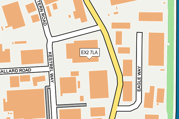
EX2 7LA is located in the St Loyes electoral ward, within the local authority district of Exeter and the English Parliamentary constituency of East Devon. The Sub Integrated Care Board (ICB) Location is NHS Devon ICB - 15N and the police force is Devon & Cornwall. This postcode has been in use since January 1980.


GetTheData
Source: OS OpenMap – Local (Ordnance Survey)
Source: OS VectorMap District (Ordnance Survey)
Licence: Open Government Licence (requires attribution)
| Easting | 296501 |
| Northing | 91982 |
| Latitude | 50.718208 |
| Longitude | -3.467488 |
GetTheData
Source: Open Postcode Geo
Licence: Open Government Licence
| Country | England |
| Postcode District | EX2 |
➜ See where EX2 is on a map ➜ Where is Exeter? | |
GetTheData
Source: Land Registry Price Paid Data
Licence: Open Government Licence
Elevation or altitude of EX2 7LA as distance above sea level:
| Metres | Feet | |
|---|---|---|
| Elevation | 10m | 33ft |
Elevation is measured from the approximate centre of the postcode, to the nearest point on an OS contour line from OS Terrain 50, which has contour spacing of ten vertical metres.
➜ How high above sea level am I? Find the elevation of your current position using your device's GPS.
GetTheData
Source: Open Postcode Elevation
Licence: Open Government Licence
| Ward | St Loyes |
| Constituency | East Devon |
GetTheData
Source: ONS Postcode Database
Licence: Open Government Licence
| Howmet (Kestrel Way) | Sowton | 84m |
| Jewsons (Kestrel Way) | Sowton | 103m |
| Environment Agency (Kestrel Way) | Sowton | 181m |
| Kestrel Way | Sowton | 181m |
| Bittern Road | Sowton | 260m |
| Digby & Sowton Station | 0.6km |
| Newcourt Station | 1.5km |
| Pinhoe Station | 2.2km |
GetTheData
Source: NaPTAN
Licence: Open Government Licence
Estimated total energy consumption in EX2 7LA by fuel type, 2015.
| Consumption (kWh) | 203,398 |
|---|---|
| Meter count | 7 |
| Mean (kWh/meter) | 29,057 |
| Median (kWh/meter) | 23,069 |
GetTheData
Source: Postcode level gas estimates: 2015 (experimental)
Source: Postcode level electricity estimates: 2015 (experimental)
Licence: Open Government Licence
GetTheData
Source: ONS Postcode Database
Licence: Open Government Licence


➜ Get more ratings from the Food Standards Agency
GetTheData
Source: Food Standards Agency
Licence: FSA terms & conditions
| Last Collection | |||
|---|---|---|---|
| Location | Mon-Fri | Sat | Distance |
| Kestrel Way | 19:30 | 187m | |
| Kestrel Way | 19:00 | 12:30 | 187m |
| Sowton Industrial Estate | 19:00 | 12:30 | 271m |
GetTheData
Source: Dracos
Licence: Creative Commons Attribution-ShareAlike
The below table lists the International Territorial Level (ITL) codes (formerly Nomenclature of Territorial Units for Statistics (NUTS) codes) and Local Administrative Units (LAU) codes for EX2 7LA:
| ITL 1 Code | Name |
|---|---|
| TLK | South West (England) |
| ITL 2 Code | Name |
| TLK4 | Devon |
| ITL 3 Code | Name |
| TLK43 | Devon CC |
| LAU 1 Code | Name |
| E07000041 | Exeter |
GetTheData
Source: ONS Postcode Directory
Licence: Open Government Licence
The below table lists the Census Output Area (OA), Lower Layer Super Output Area (LSOA), and Middle Layer Super Output Area (MSOA) for EX2 7LA:
| Code | Name | |
|---|---|---|
| OA | E00101374 | |
| LSOA | E01033234 | Exeter 011G |
| MSOA | E02004159 | Exeter 011 |
GetTheData
Source: ONS Postcode Directory
Licence: Open Government Licence
| EX2 7HU | Park Five Business Centre | 334m |
| EX2 7LL | Heron Road | 498m |
| EX2 7PP | Bardon Walk | 498m |
| EX2 7LW | Bittern Road | 503m |
| EX2 5GL | Apple Lane | 509m |
| EX2 7QF | Dart Walk | 589m |
| EX2 7PG | Sandstone Close | 591m |
| EX2 7RJ | Norman Mews | 646m |
| EX2 7PS | Woodland Drive | 651m |
| EX2 7PR | Woodland Drive | 652m |
GetTheData
Source: Open Postcode Geo; Land Registry Price Paid Data
Licence: Open Government Licence