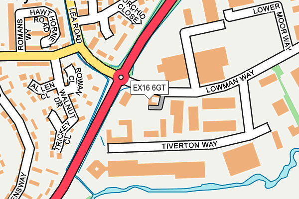
EX16 6GT lies on Lowman Way in Tiverton. EX16 6GT is located in the Tiverton Lowman electoral ward, within the local authority district of Mid Devon and the English Parliamentary constituency of Tiverton and Honiton. The Sub Integrated Care Board (ICB) Location is NHS Devon ICB - 15N and the police force is Devon & Cornwall. This postcode has been in use since July 2006.


GetTheData
Source: OS OpenMap – Local (Ordnance Survey)
Source: OS VectorMap District (Ordnance Survey)
Licence: Open Government Licence (requires attribution)
| Easting | 296920 |
| Northing | 113421 |
| Latitude | 50.911022 |
| Longitude | -3.467571 |
GetTheData
Source: Open Postcode Geo
Licence: Open Government Licence
| Street | Lowman Way |
| Town/City | Tiverton |
| Country | England |
| Postcode District | EX16 |
➜ See where EX16 is on a map ➜ Where is Tiverton? | |
GetTheData
Source: Land Registry Price Paid Data
Licence: Open Government Licence
Elevation or altitude of EX16 6GT as distance above sea level:
| Metres | Feet | |
|---|---|---|
| Elevation | 70m | 230ft |
Elevation is measured from the approximate centre of the postcode, to the nearest point on an OS contour line from OS Terrain 50, which has contour spacing of ten vertical metres.
➜ How high above sea level am I? Find the elevation of your current position using your device's GPS.
GetTheData
Source: Open Postcode Elevation
Licence: Open Government Licence
| Ward | Tiverton Lowman |
| Constituency | Tiverton And Honiton |
GetTheData
Source: ONS Postcode Database
Licence: Open Government Licence
| Homebase (Lowman Way) | Tiverton | 75m |
| Queensway | Cowleymoor | 258m |
| Queensway | Cowleymoor | 262m |
| Business Park (Lowman Way) | Tiverton | 289m |
| Marguerite Road (Lea Road) | Cowleymoor | 303m |
GetTheData
Source: NaPTAN
Licence: Open Government Licence
GetTheData
Source: ONS Postcode Database
Licence: Open Government Licence


➜ Get more ratings from the Food Standards Agency
GetTheData
Source: Food Standards Agency
Licence: FSA terms & conditions
| Last Collection | |||
|---|---|---|---|
| Location | Mon-Fri | Sat | Distance |
| Lowman Way | 17:00 | 11:30 | 90m |
| Blundells | 16:45 | 11:45 | 481m |
| St Peter Street | 17:30 | 12:00 | 1,647m |
GetTheData
Source: Dracos
Licence: Creative Commons Attribution-ShareAlike
| Risk of EX16 6GT flooding from rivers and sea | Low |
| ➜ EX16 6GT flood map | |
GetTheData
Source: Open Flood Risk by Postcode
Licence: Open Government Licence
The below table lists the International Territorial Level (ITL) codes (formerly Nomenclature of Territorial Units for Statistics (NUTS) codes) and Local Administrative Units (LAU) codes for EX16 6GT:
| ITL 1 Code | Name |
|---|---|
| TLK | South West (England) |
| ITL 2 Code | Name |
| TLK4 | Devon |
| ITL 3 Code | Name |
| TLK43 | Devon CC |
| LAU 1 Code | Name |
| E07000042 | Mid Devon |
GetTheData
Source: ONS Postcode Directory
Licence: Open Government Licence
The below table lists the Census Output Area (OA), Lower Layer Super Output Area (LSOA), and Middle Layer Super Output Area (MSOA) for EX16 6GT:
| Code | Name | |
|---|---|---|
| OA | E00165917 | |
| LSOA | E01020065 | Mid Devon 004C |
| MSOA | E02004167 | Mid Devon 004 |
GetTheData
Source: ONS Postcode Directory
Licence: Open Government Licence
| EX16 6EY | Hornbeam Close | 121m |
| EX16 6SY | Foxglove Close | 124m |
| EX16 6EX | Rowan Close | 146m |
| EX16 6HE | Walnut Drive | 161m |
| EX16 6SZ | Orchid Close | 161m |
| EX16 6SR | Lowman Way | 166m |
| EX16 6HF | Trickey Close | 206m |
| EX16 6EZ | Allen Close | 220m |
| EX16 6TB | Primrose Close | 228m |
| EX16 6SX | Bluebell Avenue | 233m |
GetTheData
Source: Open Postcode Geo; Land Registry Price Paid Data
Licence: Open Government Licence