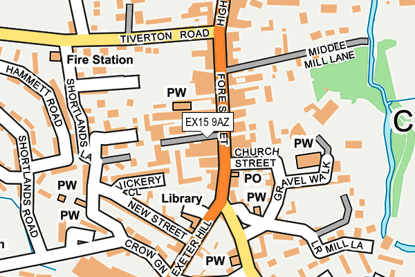
EX15 9AZ is located in the Cullompton St Andrews electoral ward, within the local authority district of Mid Devon and the English Parliamentary constituency of Tiverton and Honiton. The Sub Integrated Care Board (ICB) Location is NHS Devon ICB - 15N and the police force is Devon & Cornwall. This postcode has been in use since March 2017.


GetTheData
Source: OS OpenMap – Local (Ordnance Survey)
Source: OS VectorMap District (Ordnance Survey)
Licence: Open Government Licence (requires attribution)
| Easting | 302043 |
| Northing | 107202 |
| Latitude | 50.855999 |
| Longitude | -3.393070 |
GetTheData
Source: Open Postcode Geo
Licence: Open Government Licence
| Country | England |
| Postcode District | EX15 |
➜ See where EX15 is on a map ➜ Where is Cullompton? | |
GetTheData
Source: Land Registry Price Paid Data
Licence: Open Government Licence
| Ward | Cullompton St Andrews |
| Constituency | Tiverton And Honiton |
GetTheData
Source: ONS Postcode Database
Licence: Open Government Licence
| Hayridge Centre (Exeter Hill) | Cullompton | 90m |
| Hayridge Centre (Exeter Hill) | Cullompton | 112m |
| War Memorial (High Street) | Cullompton | 225m |
| Shortlands Lane (Tiverton Road) | Cullompton | 241m |
| Market House (High Street) | Cullompton | 248m |
GetTheData
Source: NaPTAN
Licence: Open Government Licence
GetTheData
Source: ONS Postcode Database
Licence: Open Government Licence


➜ Get more ratings from the Food Standards Agency
GetTheData
Source: Food Standards Agency
Licence: FSA terms & conditions
| Last Collection | |||
|---|---|---|---|
| Location | Mon-Fri | Sat | Distance |
| Tesco | 17:45 | 12:00 | 457m |
| St Georges Well | 17:45 | 12:00 | 832m |
| Motterton | 10:00 | 10:00 | 2,200m |
GetTheData
Source: Dracos
Licence: Creative Commons Attribution-ShareAlike
The below table lists the International Territorial Level (ITL) codes (formerly Nomenclature of Territorial Units for Statistics (NUTS) codes) and Local Administrative Units (LAU) codes for EX15 9AZ:
| ITL 1 Code | Name |
|---|---|
| TLK | South West (England) |
| ITL 2 Code | Name |
| TLK4 | Devon |
| ITL 3 Code | Name |
| TLK43 | Devon CC |
| LAU 1 Code | Name |
| E07000042 | Mid Devon |
GetTheData
Source: ONS Postcode Directory
Licence: Open Government Licence
The below table lists the Census Output Area (OA), Lower Layer Super Output Area (LSOA), and Middle Layer Super Output Area (MSOA) for EX15 9AZ:
| Code | Name | |
|---|---|---|
| OA | E00101555 | |
| LSOA | E01020057 | Mid Devon 007C |
| MSOA | E02004170 | Mid Devon 007 |
GetTheData
Source: ONS Postcode Directory
Licence: Open Government Licence
| EX15 1LF | Fore Street | 22m |
| EX15 1TL | Bakers Mews | 24m |
| EX15 1LE | New Inn Court | 35m |
| EX15 1LB | Fore Street | 40m |
| EX15 1FX | The Green | 44m |
| EX15 1JT | Fore Street | 45m |
| EX15 1LD | Fore Street | 56m |
| EX15 1JS | Fore Street | 64m |
| EX15 1JU | Church Street | 70m |
| EX15 1JY | Fore Street | 73m |
GetTheData
Source: Open Postcode Geo; Land Registry Price Paid Data
Licence: Open Government Licence