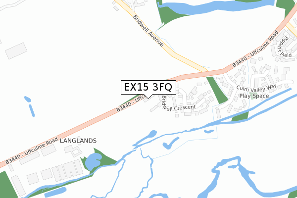
EX15 3FQ is located in the Halberton electoral ward, within the local authority district of Mid Devon and the English Parliamentary constituency of Tiverton and Honiton. The Sub Integrated Care Board (ICB) Location is NHS Devon ICB - 15N and the police force is Devon & Cornwall. This postcode has been in use since October 2019.


GetTheData
Source: OS Open Zoomstack (Ordnance Survey)
Licence: Open Government Licence (requires attribution)
Attribution: Contains OS data © Crown copyright and database right 2025
Source: Open Postcode Geo
Licence: Open Government Licence (requires attribution)
Attribution: Contains OS data © Crown copyright and database right 2025; Contains Royal Mail data © Royal Mail copyright and database right 2025; Source: Office for National Statistics licensed under the Open Government Licence v.3.0
| Easting | 305609 |
| Northing | 112101 |
| Latitude | 50.900636 |
| Longitude | -3.343688 |
GetTheData
Source: Open Postcode Geo
Licence: Open Government Licence
| Country | England |
| Postcode District | EX15 |
➜ See where EX15 is on a map ➜ Where is Uffculme? | |
GetTheData
Source: Land Registry Price Paid Data
Licence: Open Government Licence
| Ward | Halberton |
| Constituency | Tiverton And Honiton |
GetTheData
Source: ONS Postcode Database
Licence: Open Government Licence
13, HAWTHORN PLACE, UFFCULME, CULLOMPTON, EX15 3FQ 2023 23 NOV £350,000 |
11, HAWTHORN PLACE, UFFCULME, CULLOMPTON, EX15 3FQ 2023 22 FEB £340,000 |
10, HAWTHORN PLACE, UFFCULME, CULLOMPTON, EX15 3FQ 2022 22 DEC £365,000 |
GetTheData
Source: HM Land Registry Price Paid Data
Licence: Contains HM Land Registry data © Crown copyright and database right 2025. This data is licensed under the Open Government Licence v3.0.
| Bridwell Avenue | Uffculme | 305m |
| Bridwell Avenue | Uffculme | 306m |
| Coldharbour (Uffculme Road) | Uffculme | 516m |
| Coldharbour (Uffculme Road) | Uffculme | 525m |
| College Green (Commercial Road) | Uffculme | 850m |
| Tiverton Parkway Station | 2.2km |
GetTheData
Source: NaPTAN
Licence: Open Government Licence
GetTheData
Source: ONS Postcode Database
Licence: Open Government Licence


➜ Get more ratings from the Food Standards Agency
GetTheData
Source: Food Standards Agency
Licence: FSA terms & conditions
| Last Collection | |||
|---|---|---|---|
| Location | Mon-Fri | Sat | Distance |
| Tiverton Parkway | 10:00 | 10:00 | 2,169m |
| Croyle | 16:30 | 11:00 | 2,949m |
| Ayshford | 09:00 | 07:00 | 3,078m |
GetTheData
Source: Dracos
Licence: Creative Commons Attribution-ShareAlike
The below table lists the International Territorial Level (ITL) codes (formerly Nomenclature of Territorial Units for Statistics (NUTS) codes) and Local Administrative Units (LAU) codes for EX15 3FQ:
| ITL 1 Code | Name |
|---|---|
| TLK | South West (England) |
| ITL 2 Code | Name |
| TLK4 | Devon |
| ITL 3 Code | Name |
| TLK43 | Devon CC |
| LAU 1 Code | Name |
| E07000042 | Mid Devon |
GetTheData
Source: ONS Postcode Directory
Licence: Open Government Licence
The below table lists the Census Output Area (OA), Lower Layer Super Output Area (LSOA), and Middle Layer Super Output Area (MSOA) for EX15 3FQ:
| Code | Name | |
|---|---|---|
| OA | E00101560 | |
| LSOA | E01020059 | Mid Devon 006B |
| MSOA | E02004169 | Mid Devon 006 |
GetTheData
Source: ONS Postcode Directory
Licence: Open Government Licence
| EX15 3XX | Clarke Close | 293m |
| EX15 3BU | 361m | |
| EX15 3DA | 378m | |
| EX15 3XY | Caumont Close | 390m |
| EX15 3BH | Uffculme Road | 394m |
| EX15 3XZ | Culm Valley Way | 405m |
| EX15 3BS | Pippins Field | 518m |
| EX15 3EZ | Appletree Close | 612m |
| EX15 3EF | Russett Close | 630m |
| EX15 3EG | Russells Cottages | 690m |
GetTheData
Source: Open Postcode Geo; Land Registry Price Paid Data
Licence: Open Government Licence