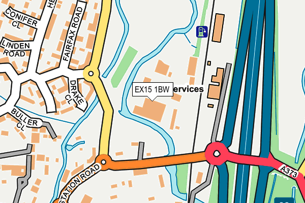
EX15 1BW is located in the Cullompton St Andrews electoral ward, within the local authority district of Mid Devon and the English Parliamentary constituency of Tiverton and Honiton. The Sub Integrated Care Board (ICB) Location is NHS Devon ICB - 15N and the police force is Devon & Cornwall. This postcode has been in use since January 1980.


GetTheData
Source: OS OpenMap – Local (Ordnance Survey)
Source: OS VectorMap District (Ordnance Survey)
Licence: Open Government Licence (requires attribution)
| Easting | 302571 |
| Northing | 107867 |
| Latitude | 50.862067 |
| Longitude | -3.385748 |
GetTheData
Source: Open Postcode Geo
Licence: Open Government Licence
| Country | England |
| Postcode District | EX15 |
➜ See where EX15 is on a map ➜ Where is Cullompton? | |
GetTheData
Source: Land Registry Price Paid Data
Licence: Open Government Licence
Elevation or altitude of EX15 1BW as distance above sea level:
| Metres | Feet | |
|---|---|---|
| Elevation | 50m | 164ft |
Elevation is measured from the approximate centre of the postcode, to the nearest point on an OS contour line from OS Terrain 50, which has contour spacing of ten vertical metres.
➜ How high above sea level am I? Find the elevation of your current position using your device's GPS.
GetTheData
Source: Open Postcode Elevation
Licence: Open Government Licence
| Ward | Cullompton St Andrews |
| Constituency | Tiverton And Honiton |
GetTheData
Source: ONS Postcode Database
Licence: Open Government Licence
| Merchants Walk (Millennium Way) | Cullompton | 146m |
| The Weary Traveller (Station Road) | Cullompton | 163m |
| The Weary Traveller (Station Road) | Cullompton | 164m |
| Merchants Walk (Millennium Way) | Cullompton | 169m |
| Fairfax Drive (Millennium Way) | Cullompton | 211m |
GetTheData
Source: NaPTAN
Licence: Open Government Licence
GetTheData
Source: ONS Postcode Database
Licence: Open Government Licence


➜ Get more ratings from the Food Standards Agency
GetTheData
Source: Food Standards Agency
Licence: FSA terms & conditions
| Last Collection | |||
|---|---|---|---|
| Location | Mon-Fri | Sat | Distance |
| Tesco | 17:45 | 12:00 | 395m |
| St Georges Well | 17:45 | 12:00 | 506m |
| Cullompton Delivery Office | 18:15 | 12:30 | 1,504m |
GetTheData
Source: Dracos
Licence: Creative Commons Attribution-ShareAlike
| Risk of EX15 1BW flooding from rivers and sea | High |
| ➜ EX15 1BW flood map | |
GetTheData
Source: Open Flood Risk by Postcode
Licence: Open Government Licence
The below table lists the International Territorial Level (ITL) codes (formerly Nomenclature of Territorial Units for Statistics (NUTS) codes) and Local Administrative Units (LAU) codes for EX15 1BW:
| ITL 1 Code | Name |
|---|---|
| TLK | South West (England) |
| ITL 2 Code | Name |
| TLK4 | Devon |
| ITL 3 Code | Name |
| TLK43 | Devon CC |
| LAU 1 Code | Name |
| E07000042 | Mid Devon |
GetTheData
Source: ONS Postcode Directory
Licence: Open Government Licence
The below table lists the Census Output Area (OA), Lower Layer Super Output Area (LSOA), and Middle Layer Super Output Area (MSOA) for EX15 1BW:
| Code | Name | |
|---|---|---|
| OA | E00101529 | |
| LSOA | E01020054 | Mid Devon 007A |
| MSOA | E02004170 | Mid Devon 007 |
GetTheData
Source: ONS Postcode Directory
Licence: Open Government Licence
| EX15 1FN | Drake Close | 189m |
| EX15 1FQ | Fairfax Drive | 208m |
| EX15 1FR | Millenium Way | 210m |
| EX15 1FL | Hawkins Place | 222m |
| EX15 1BQ | Station Road | 240m |
| EX15 1FP | Fairfax Drive | 243m |
| EX15 1FG | Head Weir Road | 248m |
| EX15 1FH | Grenville Way | 251m |
| EX15 1GF | Buller Close | 281m |
| EX15 1BE | Station Road | 322m |
GetTheData
Source: Open Postcode Geo; Land Registry Price Paid Data
Licence: Open Government Licence