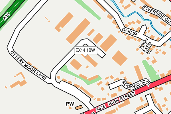
EX14 1BW is located in the Honiton St Paul's electoral ward, within the local authority district of East Devon and the English Parliamentary constituency of Tiverton and Honiton. The Sub Integrated Care Board (ICB) Location is NHS Devon ICB - 15N and the police force is Devon & Cornwall. This postcode has been in use since December 1999.


GetTheData
Source: OS OpenMap – Local (Ordnance Survey)
Source: OS VectorMap District (Ordnance Survey)
Licence: Open Government Licence (requires attribution)
| Easting | 315566 |
| Northing | 100566 |
| Latitude | 50.798472 |
| Longitude | -3.199463 |
GetTheData
Source: Open Postcode Geo
Licence: Open Government Licence
| Country | England |
| Postcode District | EX14 |
➜ See where EX14 is on a map ➜ Where is Honiton? | |
GetTheData
Source: Land Registry Price Paid Data
Licence: Open Government Licence
Elevation or altitude of EX14 1BW as distance above sea level:
| Metres | Feet | |
|---|---|---|
| Elevation | 100m | 328ft |
Elevation is measured from the approximate centre of the postcode, to the nearest point on an OS contour line from OS Terrain 50, which has contour spacing of ten vertical metres.
➜ How high above sea level am I? Find the elevation of your current position using your device's GPS.
GetTheData
Source: Open Postcode Elevation
Licence: Open Government Licence
| Ward | Honiton St Paul's |
| Constituency | Tiverton And Honiton |
GetTheData
Source: ONS Postcode Database
Licence: Open Government Licence
| Church Of The Holy Family (Exeter Road) | Honiton | 237m |
| Mill Street (High Street) | Honiton | 301m |
| Mill Street (High Street) | Honiton | 350m |
| Car Park (Dowell Street) | Honiton | 367m |
| Car Park (Dowell Street) | Honiton | 372m |
| Honiton Station | 0.9km |
GetTheData
Source: NaPTAN
Licence: Open Government Licence
GetTheData
Source: ONS Postcode Database
Licence: Open Government Licence


➜ Get more ratings from the Food Standards Agency
GetTheData
Source: Food Standards Agency
Licence: FSA terms & conditions
| Last Collection | |||
|---|---|---|---|
| Location | Mon-Fri | Sat | Distance |
| Sidmouth Road | 17:30 | 11:15 | 456m |
| Weston | 17:00 | 08:30 | 537m |
| Battishorn Way | 17:30 | 11:00 | 563m |
GetTheData
Source: Dracos
Licence: Creative Commons Attribution-ShareAlike
The below table lists the International Territorial Level (ITL) codes (formerly Nomenclature of Territorial Units for Statistics (NUTS) codes) and Local Administrative Units (LAU) codes for EX14 1BW:
| ITL 1 Code | Name |
|---|---|
| TLK | South West (England) |
| ITL 2 Code | Name |
| TLK4 | Devon |
| ITL 3 Code | Name |
| TLK43 | Devon CC |
| LAU 1 Code | Name |
| E07000040 | East Devon |
GetTheData
Source: ONS Postcode Directory
Licence: Open Government Licence
The below table lists the Census Output Area (OA), Lower Layer Super Output Area (LSOA), and Middle Layer Super Output Area (MSOA) for EX14 1BW:
| Code | Name | |
|---|---|---|
| OA | E00100882 | |
| LSOA | E01019932 | East Devon 002B |
| MSOA | E02004130 | East Devon 002 |
GetTheData
Source: ONS Postcode Directory
Licence: Open Government Licence
| EX14 1AW | Ottery Moor Lane | 110m |
| EX14 1BH | Rookwood Close | 133m |
| EX14 1AN | Exeter Road | 168m |
| EX14 1XH | Oaklea | 208m |
| EX14 1YB | Gissage View | 212m |
| EX14 1AL | Exeter Road | 213m |
| EX14 1YA | Town Farm Close | 225m |
| EX14 1AR | Ottery Moor Lane | 263m |
| EX14 1RX | Ernsborough Gardens | 272m |
| EX14 1TD | Ashleigh Road | 283m |
GetTheData
Source: Open Postcode Geo; Land Registry Price Paid Data
Licence: Open Government Licence