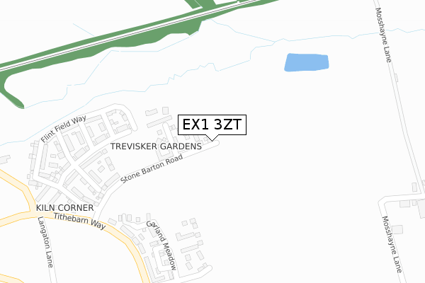
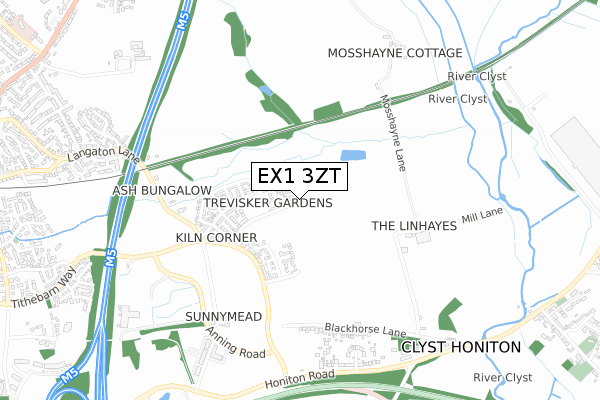
EX1 3ZT is located in the Broadclyst electoral ward, within the local authority district of East Devon and the English Parliamentary constituency of East Devon. The Sub Integrated Care Board (ICB) Location is NHS Devon ICB - 15N and the police force is Devon & Cornwall. This postcode has been in use since April 2020.


GetTheData
Source: OS Open Zoomstack (Ordnance Survey)
Licence: Open Government Licence (requires attribution)
Attribution: Contains OS data © Crown copyright and database right 2025
Source: Open Postcode Geo
Licence: Open Government Licence (requires attribution)
Attribution: Contains OS data © Crown copyright and database right 2025; Contains Royal Mail data © Royal Mail copyright and database right 2025; Source: Office for National Statistics licensed under the Open Government Licence v.3.0
| Easting | 297639 |
| Northing | 94193 |
| Latitude | 50.738287 |
| Longitude | -3.451988 |
GetTheData
Source: Open Postcode Geo
Licence: Open Government Licence
| Country | England |
| Postcode District | EX1 |
➜ See where EX1 is on a map ➜ Where is Clyst Honiton? | |
GetTheData
Source: Land Registry Price Paid Data
Licence: Open Government Licence
| Ward | Broadclyst |
| Constituency | East Devon |
GetTheData
Source: ONS Postcode Database
Licence: Open Government Licence
2024 22 AUG £607,000 |
5, FORD WAY, TITHEBARN, EXETER, EX1 3ZT 2021 29 APR £424,995 |
3, FORD WAY, TITHEBARN, EXETER, EX1 3ZT 2021 29 APR £384,995 |
7, FORD WAY, TITHEBARN, EXETER, EX1 3ZT 2021 25 MAR £399,995 |
9, FORD WAY, TITHEBARN, EXETER, EX1 3ZT 2021 25 MAR £379,995 |
1, FORD WAY, TITHEBARN, EXETER, EX1 3ZT 2021 25 MAR £366,995 |
11, FORD WAY, TITHEBARN, EXETER, EX1 3ZT 2020 17 APR £459,995 |
2020 12 MAR £534,995 |
15, FORD WAY, TITHEBARN, EXETER, EX1 3ZT 2020 27 FEB £459,995 |
GetTheData
Source: HM Land Registry Price Paid Data
Licence: Contains HM Land Registry data © Crown copyright and database right 2025. This data is licensed under the Open Government Licence v3.0.
| Langaton Gardens (Langaton Lane) | Pinhoe | 876m |
| Orchard Close | Pinhoe | 922m |
| Exeter Science Park (Old Honiton Road) | Monkerton | 940m |
| Exeter Science Park (Old Honiton Road) | Monkerton | 942m |
| The Black Horse (Old Honiton Road) | Clyst Honiton | 950m |
| Pinhoe Station | 1.2km |
| Cranbrook Station | 2.6km |
| Digby & Sowton Station | 3.1km |
GetTheData
Source: NaPTAN
Licence: Open Government Licence
GetTheData
Source: ONS Postcode Database
Licence: Open Government Licence


➜ Get more ratings from the Food Standards Agency
GetTheData
Source: Food Standards Agency
Licence: FSA terms & conditions
| Last Collection | |||
|---|---|---|---|
| Location | Mon-Fri | Sat | Distance |
| Langaton Lane | 18:15 | 13:00 | 849m |
| Stonefield | 16:10 | 09:00 | 856m |
| Monkerton | 18:15 | 12:45 | 1,204m |
GetTheData
Source: Dracos
Licence: Creative Commons Attribution-ShareAlike
The below table lists the International Territorial Level (ITL) codes (formerly Nomenclature of Territorial Units for Statistics (NUTS) codes) and Local Administrative Units (LAU) codes for EX1 3ZT:
| ITL 1 Code | Name |
|---|---|
| TLK | South West (England) |
| ITL 2 Code | Name |
| TLK4 | Devon |
| ITL 3 Code | Name |
| TLK43 | Devon CC |
| LAU 1 Code | Name |
| E07000040 | East Devon |
GetTheData
Source: ONS Postcode Directory
Licence: Open Government Licence
The below table lists the Census Output Area (OA), Lower Layer Super Output Area (LSOA), and Middle Layer Super Output Area (MSOA) for EX1 3ZT:
| Code | Name | |
|---|---|---|
| OA | E00100666 | |
| LSOA | E01019893 | East Devon 006C |
| MSOA | E02004134 | East Devon 006 |
GetTheData
Source: ONS Postcode Directory
Licence: Open Government Licence
| EX1 3TS | 620m | |
| EX5 2AR | Blackhorse Lane | 685m |
| EX1 3TD | Ash Farm Close | 730m |
| EX1 3SL | Langaton Lane | 755m |
| EX5 2AW | Endsleigh Crescent | 773m |
| EX1 3UF | Pinn Valley Road | 786m |
| EX1 3UE | Ross Close | 788m |
| EX1 3RZ | Langaton Gardens | 818m |
| EX1 3SN | Orchard Close | 905m |
| EX1 3TR | 921m |
GetTheData
Source: Open Postcode Geo; Land Registry Price Paid Data
Licence: Open Government Licence