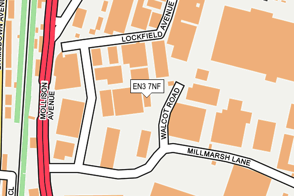
EN3 7NF is located in the Brimsdown electoral ward, within the London borough of Enfield and the English Parliamentary constituency of Enfield North. The Sub Integrated Care Board (ICB) Location is NHS North Central London ICB - 93C and the police force is Metropolitan Police. This postcode has been in use since August 1993.


GetTheData
Source: OS OpenMap – Local (Ordnance Survey)
Source: OS VectorMap District (Ordnance Survey)
Licence: Open Government Licence (requires attribution)
| Easting | 536592 |
| Northing | 197397 |
| Latitude | 51.658769 |
| Longitude | -0.026648 |
GetTheData
Source: Open Postcode Geo
Licence: Open Government Licence
| Country | England |
| Postcode District | EN3 |
➜ See where EN3 is on a map ➜ Where is London? | |
GetTheData
Source: Land Registry Price Paid Data
Licence: Open Government Licence
Elevation or altitude of EN3 7NF as distance above sea level:
| Metres | Feet | |
|---|---|---|
| Elevation | 20m | 66ft |
Elevation is measured from the approximate centre of the postcode, to the nearest point on an OS contour line from OS Terrain 50, which has contour spacing of ten vertical metres.
➜ How high above sea level am I? Find the elevation of your current position using your device's GPS.
GetTheData
Source: Open Postcode Elevation
Licence: Open Government Licence
| Ward | Brimsdown |
| Constituency | Enfield North |
GetTheData
Source: ONS Postcode Database
Licence: Open Government Licence
| Millmarsh Lane (Mollison Avenue) | Brimsdown | 191m |
| Millmarsh Lane | Brimsdown | 219m |
| Green Street Brimsdown Stn (Mollison Avenue) | Brimsdown | 296m |
| Fouracres (Brimsdown Avenue) | Brimsdown | 340m |
| Fouracres (Brimsdown Avenue) | Brimsdown | 343m |
| Brimsdown Station | 0.5km |
| Enfield Lock Station | 1.4km |
| Ponders End Station | 1.9km |
GetTheData
Source: NaPTAN
Licence: Open Government Licence
GetTheData
Source: ONS Postcode Database
Licence: Open Government Licence


➜ Get more ratings from the Food Standards Agency
GetTheData
Source: Food Standards Agency
Licence: FSA terms & conditions
| Last Collection | |||
|---|---|---|---|
| Location | Mon-Fri | Sat | Distance |
| Green Street Postoffice | 18:30 | 12:00 | 492m |
| Brimsdown Avenue | 17:30 | 12:00 | 764m |
| Avondale Crescent | 18:30 | 12:00 | 960m |
GetTheData
Source: Dracos
Licence: Creative Commons Attribution-ShareAlike
| Risk of EN3 7NF flooding from rivers and sea | Low |
| ➜ EN3 7NF flood map | |
GetTheData
Source: Open Flood Risk by Postcode
Licence: Open Government Licence
The below table lists the International Territorial Level (ITL) codes (formerly Nomenclature of Territorial Units for Statistics (NUTS) codes) and Local Administrative Units (LAU) codes for EN3 7NF:
| ITL 1 Code | Name |
|---|---|
| TLI | London |
| ITL 2 Code | Name |
| TLI5 | Outer London - East and North East |
| ITL 3 Code | Name |
| TLI54 | Enfield |
| LAU 1 Code | Name |
| E09000010 | Enfield |
GetTheData
Source: ONS Postcode Directory
Licence: Open Government Licence
The below table lists the Census Output Area (OA), Lower Layer Super Output Area (LSOA), and Middle Layer Super Output Area (MSOA) for EN3 7NF:
| Code | Name | |
|---|---|---|
| OA | E00007127 | |
| LSOA | E01001437 | Enfield 014A |
| MSOA | E02000290 | Enfield 014 |
GetTheData
Source: ONS Postcode Directory
Licence: Open Government Licence
| EN3 7JY | Lockfield Avenue | 42m |
| EN3 7PY | Lockfield Avenue | 90m |
| EN3 7PX | Lockfield Avenue | 194m |
| EN3 5HZ | Brimsdown Avenue | 286m |
| EN3 5EP | Brimsdown Avenue | 319m |
| EN3 5ER | Brimsdown Avenue | 338m |
| EN3 7PL | Brancroft Way | 372m |
| EN3 5DS | Fouracres | 384m |
| EN3 5DQ | Sharon Road | 385m |
| EN3 5EW | Brimsdown Avenue | 386m |
GetTheData
Source: Open Postcode Geo; Land Registry Price Paid Data
Licence: Open Government Licence