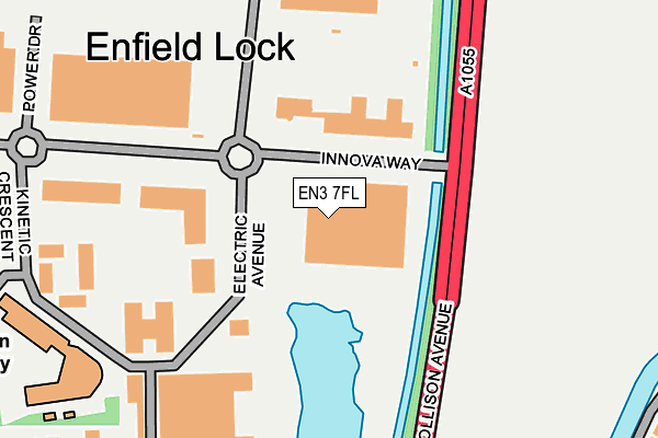
EN3 7FL is located in the Enfield Lock electoral ward, within the London borough of Enfield and the English Parliamentary constituency of Enfield North. The Sub Integrated Care Board (ICB) Location is NHS North Central London ICB - 93C and the police force is Metropolitan Police. This postcode has been in use since March 2008.


GetTheData
Source: OS OpenMap – Local (Ordnance Survey)
Source: OS VectorMap District (Ordnance Survey)
Licence: Open Government Licence (requires attribution)
| Easting | 536680 |
| Northing | 199280 |
| Latitude | 51.675669 |
| Longitude | -0.024641 |
GetTheData
Source: Open Postcode Geo
Licence: Open Government Licence
| Country | England |
| Postcode District | EN3 |
➜ See where EN3 is on a map ➜ Where is London? | |
GetTheData
Source: Land Registry Price Paid Data
Licence: Open Government Licence
Elevation or altitude of EN3 7FL as distance above sea level:
| Metres | Feet | |
|---|---|---|
| Elevation | 20m | 66ft |
Elevation is measured from the approximate centre of the postcode, to the nearest point on an OS contour line from OS Terrain 50, which has contour spacing of ten vertical metres.
➜ How high above sea level am I? Find the elevation of your current position using your device's GPS.
GetTheData
Source: Open Postcode Elevation
Licence: Open Government Licence
| Ward | Enfield Lock |
| Constituency | Enfield North |
GetTheData
Source: ONS Postcode Database
Licence: Open Government Licence
| Solar Way | Freezy Water | 186m |
| Innova Park | Freezy Water | 262m |
| Innova Park | Freezy Water | 289m |
| Mollison Avenue (Ordnance Road) | Enfield Lock | 539m |
| Enfield Lock (Ordnance Road) | Enfield Lock | 557m |
| Enfield Lock Station | 0.6km |
| Waltham Cross Station | 1.1km |
| Turkey Street Station | 1.6km |
GetTheData
Source: NaPTAN
Licence: Open Government Licence
GetTheData
Source: ONS Postcode Database
Licence: Open Government Licence


➜ Get more ratings from the Food Standards Agency
GetTheData
Source: Food Standards Agency
Licence: FSA terms & conditions
| Last Collection | |||
|---|---|---|---|
| Location | Mon-Fri | Sat | Distance |
| Enfield Lock | 17:30 | 12:00 | 562m |
| Enfield Lock Station | 17:30 | 12:00 | 567m |
| Alma Road | 17:30 | 12:00 | 856m |
GetTheData
Source: Dracos
Licence: Creative Commons Attribution-ShareAlike
| Risk of EN3 7FL flooding from rivers and sea | Low |
| ➜ EN3 7FL flood map | |
GetTheData
Source: Open Flood Risk by Postcode
Licence: Open Government Licence
The below table lists the International Territorial Level (ITL) codes (formerly Nomenclature of Territorial Units for Statistics (NUTS) codes) and Local Administrative Units (LAU) codes for EN3 7FL:
| ITL 1 Code | Name |
|---|---|
| TLI | London |
| ITL 2 Code | Name |
| TLI5 | Outer London - East and North East |
| ITL 3 Code | Name |
| TLI54 | Enfield |
| LAU 1 Code | Name |
| E09000010 | Enfield |
GetTheData
Source: ONS Postcode Directory
Licence: Open Government Licence
The below table lists the Census Output Area (OA), Lower Layer Super Output Area (LSOA), and Middle Layer Super Output Area (MSOA) for EN3 7FL:
| Code | Name | |
|---|---|---|
| OA | E00007192 | |
| LSOA | E01001445 | Enfield 003B |
| MSOA | E02000279 | Enfield 003 |
GetTheData
Source: ONS Postcode Directory
Licence: Open Government Licence
| EN3 6FL | Tysoe Avenue | 193m |
| EN3 6FH | Tysoe Avenue | 194m |
| EN3 7FJ | Kinetic Crescent | 195m |
| EN3 7XU | Innova Way | 213m |
| EN3 6FQ | Tysoe Avenue | 214m |
| EN3 6FJ | Tysoe Avenue | 218m |
| EN3 6FF | Tysoe Avenue | 220m |
| EN3 6FG | Tysoe Avenue | 232m |
| EN3 6FE | Tysoe Avenue | 250m |
| EN3 6LW | Park Road | 275m |
GetTheData
Source: Open Postcode Geo; Land Registry Price Paid Data
Licence: Open Government Licence