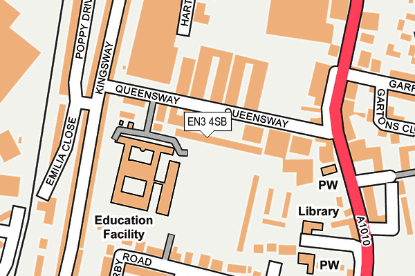
EN3 4SB lies on Peerglow Estate in Enfield. EN3 4SB is located in the Ponders End electoral ward, within the London borough of Enfield and the English Parliamentary constituency of Edmonton. The Sub Integrated Care Board (ICB) Location is NHS North Central London ICB - 93C and the police force is Metropolitan Police. This postcode has been in use since March 1988.


GetTheData
Source: OS OpenMap – Local (Ordnance Survey)
Source: OS VectorMap District (Ordnance Survey)
Licence: Open Government Licence (requires attribution)
| Easting | 535052 |
| Northing | 195977 |
| Latitude | 51.646381 |
| Longitude | -0.049446 |
GetTheData
Source: Open Postcode Geo
Licence: Open Government Licence
| Street | Peerglow Estate |
| Town/City | Enfield |
| Country | England |
| Postcode District | EN3 |
➜ See where EN3 is on a map ➜ Where is London? | |
GetTheData
Source: Land Registry Price Paid Data
Licence: Open Government Licence
Elevation or altitude of EN3 4SB as distance above sea level:
| Metres | Feet | |
|---|---|---|
| Elevation | 20m | 66ft |
Elevation is measured from the approximate centre of the postcode, to the nearest point on an OS contour line from OS Terrain 50, which has contour spacing of ten vertical metres.
➜ How high above sea level am I? Find the elevation of your current position using your device's GPS.
GetTheData
Source: Open Postcode Elevation
Licence: Open Government Licence
| Ward | Ponders End |
| Constituency | Edmonton |
GetTheData
Source: ONS Postcode Database
Licence: Open Government Licence
4, PEERGLOW ESTATE, ENFIELD, EN3 4SB 2006 13 NOV £215,000 |
GetTheData
Source: HM Land Registry Price Paid Data
Licence: Contains HM Land Registry data © Crown copyright and database right 2025. This data is licensed under the Open Government Licence v3.0.
| Ponders End Park (Ponders End High Street) | Ponders End | 187m |
| Southbury Road Durants Road | Ponders End | 227m |
| Southbury Road Durants Road | Ponders End | 253m |
| Glyn Road (En3) | Ponders End | 254m |
| Enfield Bus Garage Southbury Station | Ponders End | 258m |
| Southbury Station | 0.3km |
| Ponders End Station | 1.1km |
| Bush Hill Park Station | 1.5km |
GetTheData
Source: NaPTAN
Licence: Open Government Licence
GetTheData
Source: ONS Postcode Database
Licence: Open Government Licence


➜ Get more ratings from the Food Standards Agency
GetTheData
Source: Food Standards Agency
Licence: FSA terms & conditions
| Last Collection | |||
|---|---|---|---|
| Location | Mon-Fri | Sat | Distance |
| Southbury Road | 17:30 | 12:00 | 289m |
| Aberdare Road | 17:30 | 12:00 | 442m |
| Northfield Road | 17:30 | 12:00 | 484m |
GetTheData
Source: Dracos
Licence: Creative Commons Attribution-ShareAlike
The below table lists the International Territorial Level (ITL) codes (formerly Nomenclature of Territorial Units for Statistics (NUTS) codes) and Local Administrative Units (LAU) codes for EN3 4SB:
| ITL 1 Code | Name |
|---|---|
| TLI | London |
| ITL 2 Code | Name |
| TLI5 | Outer London - East and North East |
| ITL 3 Code | Name |
| TLI54 | Enfield |
| LAU 1 Code | Name |
| E09000010 | Enfield |
GetTheData
Source: ONS Postcode Directory
Licence: Open Government Licence
The below table lists the Census Output Area (OA), Lower Layer Super Output Area (LSOA), and Middle Layer Super Output Area (MSOA) for EN3 4SB:
| Code | Name | |
|---|---|---|
| OA | E00171158 | |
| LSOA | E01001508 | Enfield 012E |
| MSOA | E02000288 | Enfield 012 |
GetTheData
Source: ONS Postcode Directory
Licence: Open Government Licence
| EN3 4SA | Queensway | 59m |
| EN3 4EZ | High Street | 165m |
| EN3 4HB | High Street | 167m |
| EN3 4HT | Kingsway | 170m |
| EN3 4AL | Loraine Close | 178m |
| EN3 4AJ | Derby Road | 179m |
| EN3 4DB | Derby Road | 180m |
| EN3 4DR | High Street | 197m |
| EN3 4HU | Kingsway | 207m |
| EN3 4DP | High Street | 208m |
GetTheData
Source: Open Postcode Geo; Land Registry Price Paid Data
Licence: Open Government Licence