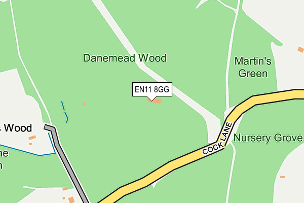
EN11 8GG is located in the Hertford Heath & Brickendon electoral ward, within the local authority district of East Hertfordshire and the English Parliamentary constituency of Hertford and Stortford. The Sub Integrated Care Board (ICB) Location is NHS Hertfordshire and West Essex ICB - 06K and the police force is Hertfordshire. This postcode has been in use since June 2001.


GetTheData
Source: OS OpenMap – Local (Ordnance Survey)
Source: OS VectorMap District (Ordnance Survey)
Licence: Open Government Licence (requires attribution)
| Easting | 534537 |
| Northing | 207715 |
| Latitude | 51.751980 |
| Longitude | -0.052387 |
GetTheData
Source: Open Postcode Geo
Licence: Open Government Licence
| Country | England |
| Postcode District | EN11 |
➜ See where EN11 is on a map | |
GetTheData
Source: Land Registry Price Paid Data
Licence: Open Government Licence
Elevation or altitude of EN11 8GG as distance above sea level:
| Metres | Feet | |
|---|---|---|
| Elevation | 70m | 230ft |
Elevation is measured from the approximate centre of the postcode, to the nearest point on an OS contour line from OS Terrain 50, which has contour spacing of ten vertical metres.
➜ How high above sea level am I? Find the elevation of your current position using your device's GPS.
GetTheData
Source: Open Postcode Elevation
Licence: Open Government Licence
| Ward | Hertford Heath & Brickendon |
| Constituency | Hertford And Stortford |
GetTheData
Source: ONS Postcode Database
Licence: Open Government Licence
| Paradise Wildlife Park (White Stubbs Lane) | Brickendon | 1,110m |
| Broxbourne Station | 2.9km |
| Bayford Station | 3.1km |
| Rye House Station | 4.4km |
GetTheData
Source: NaPTAN
Licence: Open Government Licence
GetTheData
Source: ONS Postcode Database
Licence: Open Government Licence


➜ Get more ratings from the Food Standards Agency
GetTheData
Source: Food Standards Agency
Licence: FSA terms & conditions
| Last Collection | |||
|---|---|---|---|
| Location | Mon-Fri | Sat | Distance |
| Cold Hall | 16:45 | 08:00 | 932m |
| Goose Green | 18:00 | 08:00 | 1,450m |
| Baas Hill | 18:15 | 11:00 | 1,823m |
GetTheData
Source: Dracos
Licence: Creative Commons Attribution-ShareAlike
The below table lists the International Territorial Level (ITL) codes (formerly Nomenclature of Territorial Units for Statistics (NUTS) codes) and Local Administrative Units (LAU) codes for EN11 8GG:
| ITL 1 Code | Name |
|---|---|
| TLH | East |
| ITL 2 Code | Name |
| TLH2 | Bedfordshire and Hertfordshire |
| ITL 3 Code | Name |
| TLH23 | Hertfordshire CC |
| LAU 1 Code | Name |
| E07000242 | East Hertfordshire |
GetTheData
Source: ONS Postcode Directory
Licence: Open Government Licence
The below table lists the Census Output Area (OA), Lower Layer Super Output Area (LSOA), and Middle Layer Super Output Area (MSOA) for EN11 8GG:
| Code | Name | |
|---|---|---|
| OA | E00119258 | |
| LSOA | E01023481 | East Hertfordshire 018D |
| MSOA | E02004895 | East Hertfordshire 018 |
GetTheData
Source: ONS Postcode Directory
Licence: Open Government Licence
| EN10 7QT | Broxbourne Common | 251m |
| EN10 7QS | Broxbourne Common | 698m |
| EN10 7JA | Broxbournebury Mews | 859m |
| EN10 7PZ | White Stubbs Lane | 901m |
| EN10 7QR | Pembridge Lane | 1057m |
| EN11 8SP | Goose Green | 1107m |
| EN10 7QA | White Stubbs Lane | 1209m |
| EN11 8SL | Lord Street | 1254m |
| SG13 8QJ | Mangrove Lane | 1295m |
| EN10 7QB | Carneles Green | 1335m |
GetTheData
Source: Open Postcode Geo; Land Registry Price Paid Data
Licence: Open Government Licence