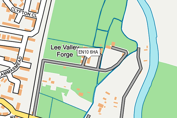
EN10 6HA is located in the Wormley and Turnford electoral ward, within the local authority district of Broxbourne and the English Parliamentary constituency of Broxbourne. The Sub Integrated Care Board (ICB) Location is NHS Hertfordshire and West Essex ICB - 06K and the police force is Hertfordshire. This postcode has been in use since January 1980.


GetTheData
Source: OS OpenMap – Local (Ordnance Survey)
Source: OS VectorMap District (Ordnance Survey)
Licence: Open Government Licence (requires attribution)
| Easting | 537089 |
| Northing | 205705 |
| Latitude | 51.733300 |
| Longitude | -0.016232 |
GetTheData
Source: Open Postcode Geo
Licence: Open Government Licence
| Country | England |
| Postcode District | EN10 |
➜ See where EN10 is on a map ➜ Where is Hoddesdon? | |
GetTheData
Source: Land Registry Price Paid Data
Licence: Open Government Licence
Elevation or altitude of EN10 6HA as distance above sea level:
| Metres | Feet | |
|---|---|---|
| Elevation | 30m | 98ft |
Elevation is measured from the approximate centre of the postcode, to the nearest point on an OS contour line from OS Terrain 50, which has contour spacing of ten vertical metres.
➜ How high above sea level am I? Find the elevation of your current position using your device's GPS.
GetTheData
Source: Open Postcode Elevation
Licence: Open Government Licence
| Ward | Wormley And Turnford |
| Constituency | Broxbourne |
GetTheData
Source: ONS Postcode Database
Licence: Open Government Licence
| Old Star Ph (High Road) | Wormley | 490m |
| Old Star Ph (High Road) | Wormley | 500m |
| New River Garage (High Road) | Broxbourne | 593m |
| New River Garage (High Road) | Broxbourne | 641m |
| The Queens Head Ph (High Road) | Wormley | 653m |
| Broxbourne Station | 1.6km |
| Cheshunt Station | 3.4km |
| Rye House Station | 4.3km |
GetTheData
Source: NaPTAN
Licence: Open Government Licence
GetTheData
Source: ONS Postcode Database
Licence: Open Government Licence


➜ Get more ratings from the Food Standards Agency
GetTheData
Source: Food Standards Agency
Licence: FSA terms & conditions
| Last Collection | |||
|---|---|---|---|
| Location | Mon-Fri | Sat | Distance |
| Wormley Post Office | 17:30 | 12:00 | 508m |
| Wormley P.o | 18:15 | 12:00 | 593m |
| New River | 17:30 | 11:30 | 705m |
GetTheData
Source: Dracos
Licence: Creative Commons Attribution-ShareAlike
| Risk of EN10 6HA flooding from rivers and sea | Low |
| ➜ EN10 6HA flood map | |
GetTheData
Source: Open Flood Risk by Postcode
Licence: Open Government Licence
The below table lists the International Territorial Level (ITL) codes (formerly Nomenclature of Territorial Units for Statistics (NUTS) codes) and Local Administrative Units (LAU) codes for EN10 6HA:
| ITL 1 Code | Name |
|---|---|
| TLH | East |
| ITL 2 Code | Name |
| TLH2 | Bedfordshire and Hertfordshire |
| ITL 3 Code | Name |
| TLH23 | Hertfordshire CC |
| LAU 1 Code | Name |
| E07000095 | Broxbourne |
GetTheData
Source: ONS Postcode Directory
Licence: Open Government Licence
The below table lists the Census Output Area (OA), Lower Layer Super Output Area (LSOA), and Middle Layer Super Output Area (MSOA) for EN10 6HA:
| Code | Name | |
|---|---|---|
| OA | E00118583 | |
| LSOA | E01023340 | Broxbourne 005A |
| MSOA | E02004847 | Broxbourne 005 |
GetTheData
Source: ONS Postcode Directory
Licence: Open Government Licence
| EN10 6HF | Wharf Road | 16m |
| EN10 6HD | Wharf Road | 190m |
| EN10 6HY | Lammasmead | 233m |
| EN10 6NT | Clyfton Close | 236m |
| EN10 6NX | Clyfton Close | 243m |
| EN10 6PG | Lammasmead | 279m |
| EN10 6HZ | Wharf Road | 287m |
| EN10 6NZ | Fern Close | 307m |
| EN10 6NU | Clyfton Close | 328m |
| EN10 6NY | Clyfton Close | 344m |
GetTheData
Source: Open Postcode Geo; Land Registry Price Paid Data
Licence: Open Government Licence