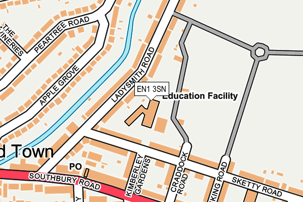
EN1 3SN is located in the Southbury electoral ward, within the London borough of Enfield and the English Parliamentary constituency of Enfield North. The Sub Integrated Care Board (ICB) Location is NHS North Central London ICB - 93C and the police force is Metropolitan Police. This postcode has been in use since January 1980.


GetTheData
Source: OS OpenMap – Local (Ordnance Survey)
Source: OS VectorMap District (Ordnance Survey)
Licence: Open Government Licence (requires attribution)
| Easting | 533577 |
| Northing | 196727 |
| Latitude | 51.653471 |
| Longitude | -0.070491 |
GetTheData
Source: Open Postcode Geo
Licence: Open Government Licence
| Country | England |
| Postcode District | EN1 |
➜ See where EN1 is on a map ➜ Where is London? | |
GetTheData
Source: Land Registry Price Paid Data
Licence: Open Government Licence
Elevation or altitude of EN1 3SN as distance above sea level:
| Metres | Feet | |
|---|---|---|
| Elevation | 30m | 98ft |
Elevation is measured from the approximate centre of the postcode, to the nearest point on an OS contour line from OS Terrain 50, which has contour spacing of ten vertical metres.
➜ How high above sea level am I? Find the elevation of your current position using your device's GPS.
GetTheData
Source: Open Postcode Elevation
Licence: Open Government Licence
| Ward | Southbury |
| Constituency | Enfield North |
GetTheData
Source: ONS Postcode Database
Licence: Open Government Licence
| Cecil Avenue (En1) (Southbury Road) | Enfield | 199m |
| Southbury Road Enfield Town | Enfield Town | 246m |
| Cecil Avenue (En1) (Southbury Road) | Enfield | 271m |
| Ladysmith Road Enfield | Enfield Town | 283m |
| Ladysmith Road Enfield | Enfield Town | 340m |
| Enfield Town Station | 0.6km |
| Bush Hill Park Station | 1.3km |
| Southbury Station | 1.4km |
GetTheData
Source: NaPTAN
Licence: Open Government Licence
GetTheData
Source: ONS Postcode Database
Licence: Open Government Licence


➜ Get more ratings from the Food Standards Agency
GetTheData
Source: Food Standards Agency
Licence: FSA terms & conditions
| Last Collection | |||
|---|---|---|---|
| Location | Mon-Fri | Sat | Distance |
| Southbury Road | 17:30 | 12:00 | 199m |
| Carnarvon Avenue | 17:30 | 12:00 | 227m |
| London Road P.o. | 18:30 | 12:00 | 420m |
GetTheData
Source: Dracos
Licence: Creative Commons Attribution-ShareAlike
The below table lists the International Territorial Level (ITL) codes (formerly Nomenclature of Territorial Units for Statistics (NUTS) codes) and Local Administrative Units (LAU) codes for EN1 3SN:
| ITL 1 Code | Name |
|---|---|
| TLI | London |
| ITL 2 Code | Name |
| TLI5 | Outer London - East and North East |
| ITL 3 Code | Name |
| TLI54 | Enfield |
| LAU 1 Code | Name |
| E09000010 | Enfield |
GetTheData
Source: ONS Postcode Directory
Licence: Open Government Licence
The below table lists the Census Output Area (OA), Lower Layer Super Output Area (LSOA), and Middle Layer Super Output Area (MSOA) for EN1 3SN:
| Code | Name | |
|---|---|---|
| OA | E00007526 | |
| LSOA | E01001518 | Enfield 016F |
| MSOA | E02000292 | Enfield 016 |
GetTheData
Source: ONS Postcode Directory
Licence: Open Government Licence
| EN1 3AJ | Ladysmith Road | 51m |
| EN1 3SF | Sketty Road | 99m |
| EN1 3SE | Sketty Road | 121m |
| EN1 3AA | Ladysmith Road | 131m |
| EN1 3SW | Kimberley Gardens | 135m |
| EN1 3DB | Apple Grove | 138m |
| EN1 3SR | Craddock Road | 153m |
| EN1 3SG | Sketty Road | 158m |
| EN1 3AL | Ladysmith Road | 181m |
| EN1 1YD | Southbury Road | 185m |
GetTheData
Source: Open Postcode Geo; Land Registry Price Paid Data
Licence: Open Government Licence