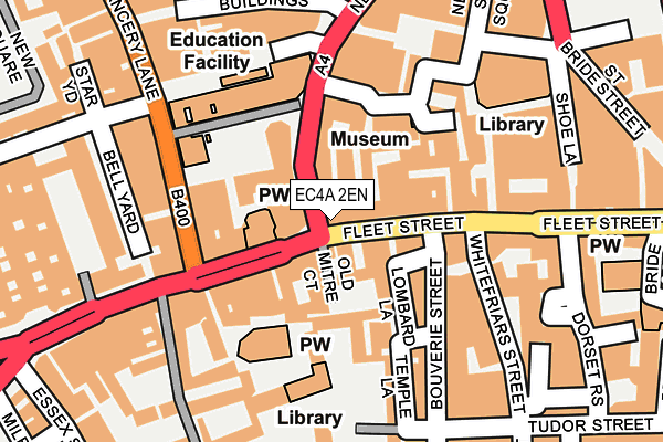
EC4A 2EN lies on Fleet Street in London. EC4A 2EN is located in the Castle Baynard electoral ward, within the London borough of City of London and the English Parliamentary constituency of Cities of London and Westminster. The Sub Integrated Care Board (ICB) Location is NHS North East London ICB - A3A8R and the police force is City of London. This postcode has been in use since January 1980.


GetTheData
Source: OS OpenMap – Local (Ordnance Survey)
Source: OS VectorMap District (Ordnance Survey)
Licence: Open Government Licence (requires attribution)
| Easting | 531293 |
| Northing | 181175 |
| Latitude | 51.514251 |
| Longitude | -0.109298 |
GetTheData
Source: Open Postcode Geo
Licence: Open Government Licence
| Street | Fleet Street |
| Town/City | London |
| Country | England |
| Postcode District | EC4A |
➜ See where EC4A is on a map ➜ Where is City of London? | |
GetTheData
Source: Land Registry Price Paid Data
Licence: Open Government Licence
Elevation or altitude of EC4A 2EN as distance above sea level:
| Metres | Feet | |
|---|---|---|
| Elevation | 10m | 33ft |
Elevation is measured from the approximate centre of the postcode, to the nearest point on an OS contour line from OS Terrain 50, which has contour spacing of ten vertical metres.
➜ How high above sea level am I? Find the elevation of your current position using your device's GPS.
GetTheData
Source: Open Postcode Elevation
Licence: Open Government Licence
| Ward | Castle Baynard |
| Constituency | Cities Of London And Westminster |
GetTheData
Source: ONS Postcode Database
Licence: Open Government Licence
| Fetter Lane (Fleet Street) | City Of London | 38m |
| Fetter Lane (Fleet Street) | City Of London | 64m |
| Chancery Lane (Ec4) (Fleet Street) | City Of London | 90m |
| Fetter Lane (New Fetter Lane) | City Of London | 124m |
| Shoe Lane (Fleet Street) | City Of London | 186m |
| Chancery Lane Underground Station | Chancery Lane | 472m |
| Blackfriars Underground Station | Blackfriars | 491m |
| Temple Underground Station | Temple | 499m |
| Farringdon Underground Station | Farringdon | 733m |
| St. Paul's Underground Station | St Pauls | 818m |
| City Thameslink Station | 0.4km |
| London Blackfriars Station | 0.5km |
| Farringdon (London) Station | 0.7km |
GetTheData
Source: NaPTAN
Licence: Open Government Licence
GetTheData
Source: ONS Postcode Database
Licence: Open Government Licence


➜ Get more ratings from the Food Standards Agency
GetTheData
Source: Food Standards Agency
Licence: FSA terms & conditions
| Last Collection | |||
|---|---|---|---|
| Location | Mon-Fri | Sat | Distance |
| Fleet Street (Whitefriars St) | 18:30 | 12:00 | 124m |
| Strand (Bell Yard) | 18:30 | 12:00 | 169m |
| Temple (Kings Bench) | 18:30 | 12:00 | 178m |
GetTheData
Source: Dracos
Licence: Creative Commons Attribution-ShareAlike
The below table lists the International Territorial Level (ITL) codes (formerly Nomenclature of Territorial Units for Statistics (NUTS) codes) and Local Administrative Units (LAU) codes for EC4A 2EN:
| ITL 1 Code | Name |
|---|---|
| TLI | London |
| ITL 2 Code | Name |
| TLI3 | Inner London - West |
| ITL 3 Code | Name |
| TLI31 | Camden and City of London |
| LAU 1 Code | Name |
| E09000001 | City of London |
GetTheData
Source: ONS Postcode Directory
Licence: Open Government Licence
The below table lists the Census Output Area (OA), Lower Layer Super Output Area (LSOA), and Middle Layer Super Output Area (MSOA) for EC4A 2EN:
| Code | Name | |
|---|---|---|
| OA | E00000025 | |
| LSOA | E01032740 | City of London 001G |
| MSOA | E02000001 | City of London 001 |
GetTheData
Source: ONS Postcode Directory
Licence: Open Government Licence
| EC4A 2HG | Fleet Street | 26m |
| EC4A 2EJ | Crane Court | 44m |
| EC4A 2DY | Fleet Street | 53m |
| EC4Y 1JU | Fleet Street | 54m |
| EC4A 3EB | Red Lion Court | 60m |
| EC4A 1BX | Fetter Lane | 62m |
| EC4A 1BY | Fetter Lane | 62m |
| EC4A 2DX | Fleet Street | 79m |
| EC4A 1BF | Fetter Lane | 90m |
| EC4A 3EA | Johnsons Court | 97m |
GetTheData
Source: Open Postcode Geo; Land Registry Price Paid Data
Licence: Open Government Licence