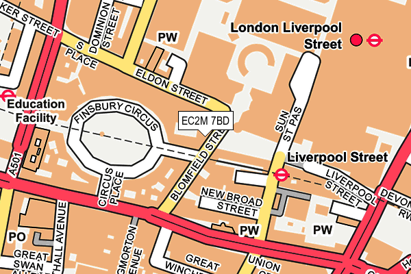
EC2M 7BD is located in the Coleman Street electoral ward, within the London borough of City of London and the English Parliamentary constituency of Cities of London and Westminster. The Sub Integrated Care Board (ICB) Location is NHS North East London ICB - A3A8R and the police force is City of London. This postcode has been in use since January 1992.


GetTheData
Source: OS OpenMap – Local (Ordnance Survey)
Source: OS VectorMap District (Ordnance Survey)
Licence: Open Government Licence (requires attribution)
| Easting | 532997 |
| Northing | 181618 |
| Latitude | 51.517836 |
| Longitude | -0.084563 |
GetTheData
Source: Open Postcode Geo
Licence: Open Government Licence
| Country | England |
| Postcode District | EC2M |
➜ See where EC2M is on a map ➜ Where is City of London? | |
GetTheData
Source: Land Registry Price Paid Data
Licence: Open Government Licence
Elevation or altitude of EC2M 7BD as distance above sea level:
| Metres | Feet | |
|---|---|---|
| Elevation | 10m | 33ft |
Elevation is measured from the approximate centre of the postcode, to the nearest point on an OS contour line from OS Terrain 50, which has contour spacing of ten vertical metres.
➜ How high above sea level am I? Find the elevation of your current position using your device's GPS.
GetTheData
Source: Open Postcode Elevation
Licence: Open Government Licence
| Ward | Coleman Street |
| Constituency | Cities Of London And Westminster |
GetTheData
Source: ONS Postcode Database
Licence: Open Government Licence
| Eldon Street Liverpool Street (Eldon Street) | Liverpool Street | 71m |
| Liverpool Street Station (Liverpool Street) | Liverpool Street | 73m |
| Liverpool Street Station (Sun Street Passage) | Liverpool Street | 126m |
| All Hallows Church | Bishopsgate | 128m |
| Liverpool Street Station (Sun Street Passage) | Liverpool Street | 130m |
| Liverpool Street Underground Station | Liverpool Street | 110m |
| Moorgate Underground Station | Moorgate | 262m |
| Bank Underground Station | Bank | 577m |
| Bank Dlr Station (Cornhill) | Bank | 580m |
| Aldgate Underground Station | Aldgate | 736m |
| London Liverpool Street Station | 0.2km |
| Moorgate Station | 0.3km |
| London Fenchurch Street Station | 0.8km |
GetTheData
Source: NaPTAN
Licence: Open Government Licence
GetTheData
Source: ONS Postcode Database
Licence: Open Government Licence


➜ Get more ratings from the Food Standards Agency
GetTheData
Source: Food Standards Agency
Licence: FSA terms & conditions
| Last Collection | |||
|---|---|---|---|
| Location | Mon-Fri | Sat | Distance |
| Blomfield St (Liverpool St) | 18:30 | 13m | |
| Blomfield Street (Liverpool St | 18:30 | 12:00 | 15m |
| Liverpool Street (O/S Station) | 18:30 | 12:00 | 119m |
GetTheData
Source: Dracos
Licence: Creative Commons Attribution-ShareAlike
The below table lists the International Territorial Level (ITL) codes (formerly Nomenclature of Territorial Units for Statistics (NUTS) codes) and Local Administrative Units (LAU) codes for EC2M 7BD:
| ITL 1 Code | Name |
|---|---|
| TLI | London |
| ITL 2 Code | Name |
| TLI3 | Inner London - West |
| ITL 3 Code | Name |
| TLI31 | Camden and City of London |
| LAU 1 Code | Name |
| E09000001 | City of London |
GetTheData
Source: ONS Postcode Directory
Licence: Open Government Licence
The below table lists the Census Output Area (OA), Lower Layer Super Output Area (LSOA), and Middle Layer Super Output Area (MSOA) for EC2M 7BD:
| Code | Name | |
|---|---|---|
| OA | E00166755 | |
| LSOA | E01032739 | City of London 001F |
| MSOA | E02000001 | City of London 001 |
GetTheData
Source: ONS Postcode Directory
Licence: Open Government Licence
| EC2M 7AJ | Blomfield Street | 103m |
| EC2M 1QT | Old Broad Street | 121m |
| EC2M 7LS | Eldon Street | 125m |
| EC2N 2BY | Throgmorton Avenue | 161m |
| EC2N 2JA | Great Winchester Street | 204m |
| EC2M 1RP | Wormwood Street | 206m |
| EC2M 5QD | London Wall | 225m |
| EC2M 1RQ | Wormwood Street | 237m |
| EC2M 2PL | Sun Street | 252m |
| EC2M 5TE | London Wall | 256m |
GetTheData
Source: Open Postcode Geo; Land Registry Price Paid Data
Licence: Open Government Licence