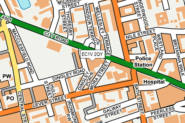
EC1V 2QY is located in the St Peter's & Canalside electoral ward, within the London borough of Islington and the English Parliamentary constituency of Islington South and Finsbury. The Sub Integrated Care Board (ICB) Location is NHS North Central London ICB - 93C and the police force is Metropolitan Police. This postcode has been in use since December 2009.


GetTheData
Source: OS OpenMap – Local (Ordnance Survey)
Source: OS VectorMap District (Ordnance Survey)
Licence: Open Government Licence (requires attribution)
| Easting | 532351 |
| Northing | 182775 |
| Latitude | 51.528383 |
| Longitude | -0.093460 |
GetTheData
Source: Open Postcode Geo
Licence: Open Government Licence
| Country | England |
| Postcode District | EC1V |
➜ See where EC1V is on a map ➜ Where is London? | |
GetTheData
Source: Land Registry Price Paid Data
Licence: Open Government Licence
Elevation or altitude of EC1V 2QY as distance above sea level:
| Metres | Feet | |
|---|---|---|
| Elevation | 20m | 66ft |
Elevation is measured from the approximate centre of the postcode, to the nearest point on an OS contour line from OS Terrain 50, which has contour spacing of ten vertical metres.
➜ How high above sea level am I? Find the elevation of your current position using your device's GPS.
GetTheData
Source: Open Postcode Elevation
Licence: Open Government Licence
| Ward | St Peter's & Canalside |
| Constituency | Islington South And Finsbury |
GetTheData
Source: ONS Postcode Database
Licence: Open Government Licence
| Windsor Terrace | Old Street | 24m |
| Windsor Terrace (City Road) | Old Street | 41m |
| Shoreditch Police Station | Hoxton | 115m |
| Shoreditch Police Station | Hoxton | 145m |
| Ironmonger Row Norman Street | Old Street | 177m |
| Old Street Underground Station | Old Street | 484m |
| Barbican Underground Station | Barbican | 955m |
| Angel Underground Station | Angel | 983m |
| Moorgate Underground Station | Moorgate | 1,190m |
| Farringdon Underground Station | Farringdon | 1,204m |
| Old Street Station | 0.4km |
| Moorgate Station | 1.1km |
| Farringdon (London) Station | 1.2km |
GetTheData
Source: NaPTAN
Licence: Open Government Licence
GetTheData
Source: ONS Postcode Database
Licence: Open Government Licence


➜ Get more ratings from the Food Standards Agency
GetTheData
Source: Food Standards Agency
Licence: FSA terms & conditions
| Last Collection | |||
|---|---|---|---|
| Location | Mon-Fri | Sat | Distance |
| City Road (Opp Bath St) | 18:30 | 12:00 | 133m |
| Micawber Street/Thoresby St | 18:30 | 12:00 | 186m |
| Lever Street (Central St) | 18:30 | 12:00 | 258m |
GetTheData
Source: Dracos
Licence: Creative Commons Attribution-ShareAlike
The below table lists the International Territorial Level (ITL) codes (formerly Nomenclature of Territorial Units for Statistics (NUTS) codes) and Local Administrative Units (LAU) codes for EC1V 2QY:
| ITL 1 Code | Name |
|---|---|
| TLI | London |
| ITL 2 Code | Name |
| TLI4 | Inner London - East |
| ITL 3 Code | Name |
| TLI43 | Haringey and Islington |
| LAU 1 Code | Name |
| E09000019 | Islington |
GetTheData
Source: ONS Postcode Directory
Licence: Open Government Licence
The below table lists the Census Output Area (OA), Lower Layer Super Output Area (LSOA), and Middle Layer Super Output Area (MSOA) for EC1V 2QY:
| Code | Name | |
|---|---|---|
| OA | E00013425 | |
| LSOA | E01002702 | Islington 023B |
| MSOA | E02000576 | Islington 023 |
GetTheData
Source: ONS Postcode Directory
Licence: Open Government Licence
| EC1V 8BR | Dingley Place | 50m |
| EC1V 8BT | Mora Street | 58m |
| N1 7NA | Wellesley Terrace | 62m |
| EC1V 8BP | Dingley Place | 72m |
| EC1V 2PN | City Road | 76m |
| EC1V 8EH | Mora Street | 77m |
| EC1V 8EJ | Mora Street | 77m |
| N1 7TJ | Thoresby Street | 87m |
| EC1V 8BD | Lever Street | 89m |
| EC1V 8BF | Lever Street | 89m |
GetTheData
Source: Open Postcode Geo; Land Registry Price Paid Data
Licence: Open Government Licence