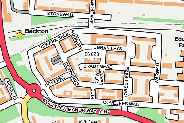
E6 6ZB is located in the Beckton electoral ward, within the London borough of Newham and the English Parliamentary constituency of East Ham. The Sub Integrated Care Board (ICB) Location is NHS North East London ICB - A3A8R and the police force is Metropolitan Police. This postcode has been in use since December 1999.


GetTheData
Source: OS OpenMap – Local (Ordnance Survey)
Source: OS VectorMap District (Ordnance Survey)
Licence: Open Government Licence (requires attribution)
| Easting | 543382 |
| Northing | 181415 |
| Latitude | 51.513472 |
| Longitude | 0.064900 |
GetTheData
Source: Open Postcode Geo
Licence: Open Government Licence
| Country | England |
| Postcode District | E6 |
➜ See where E6 is on a map ➜ Where is London? | |
GetTheData
Source: Land Registry Price Paid Data
Licence: Open Government Licence
Elevation or altitude of E6 6ZB as distance above sea level:
| Metres | Feet | |
|---|---|---|
| Elevation | 10m | 33ft |
Elevation is measured from the approximate centre of the postcode, to the nearest point on an OS contour line from OS Terrain 50, which has contour spacing of ten vertical metres.
➜ How high above sea level am I? Find the elevation of your current position using your device's GPS.
GetTheData
Source: Open Postcode Elevation
Licence: Open Government Licence
| Ward | Beckton |
| Constituency | East Ham |
GetTheData
Source: ONS Postcode Database
Licence: Open Government Licence
| East Ham Manor Way Covelees Wall | Beckton | 154m |
| East Ham Manor Way Covelees Wall | Beckton | 186m |
| Horse Leaze (Woolwich Manor Way) | Cyprus | 204m |
| Windsor Park Estate | Cyprus | 217m |
| Horse Leaze (Woolwich Manor Way) | Cyprus | 219m |
| Beckton Dlr Station (Woolwich Manor Road) | Beckton | 259m |
| Cyprus Dlr Station (Royal Albert Way) | Cyprus | 560m |
| Gallions Reach Dlr Station (Royal Docks Road) | Gallions Reach | 684m |
| Beckton Park Dlr Station (Royal Albert Way) | Beckton Park | 866m |
| King George V Dlr Station (Rymill Street) | Silvertown | 1,286m |
| Woolwich Dockyard Station | 2.6km |
| Woolwich Arsenal Station | 2.6km |
| Plumstead Station | 3km |
GetTheData
Source: NaPTAN
Licence: Open Government Licence
GetTheData
Source: ONS Postcode Database
Licence: Open Government Licence


➜ Get more ratings from the Food Standards Agency
GetTheData
Source: Food Standards Agency
Licence: FSA terms & conditions
| Last Collection | |||
|---|---|---|---|
| Location | Mon-Fri | Sat | Distance |
| Winsor Terrace | 17:30 | 11:30 | 254m |
| Pearl Close | 17:30 | 11:30 | 298m |
| Alpine Way | 505m | ||
GetTheData
Source: Dracos
Licence: Creative Commons Attribution-ShareAlike
| Risk of E6 6ZB flooding from rivers and sea | Very Low |
| ➜ E6 6ZB flood map | |
GetTheData
Source: Open Flood Risk by Postcode
Licence: Open Government Licence
The below table lists the International Territorial Level (ITL) codes (formerly Nomenclature of Territorial Units for Statistics (NUTS) codes) and Local Administrative Units (LAU) codes for E6 6ZB:
| ITL 1 Code | Name |
|---|---|
| TLI | London |
| ITL 2 Code | Name |
| TLI4 | Inner London - East |
| ITL 3 Code | Name |
| TLI41 | Hackney and Newham |
| LAU 1 Code | Name |
| E09000025 | Newham |
GetTheData
Source: ONS Postcode Directory
Licence: Open Government Licence
The below table lists the Census Output Area (OA), Lower Layer Super Output Area (LSOA), and Middle Layer Super Output Area (MSOA) for E6 6ZB:
| Code | Name | |
|---|---|---|
| OA | E00175085 | |
| LSOA | E01003487 | Newham 033D |
| MSOA | E02000746 | Newham 033 |
GetTheData
Source: ONS Postcode Directory
Licence: Open Government Licence
| E6 6WX | Cow Leaze | 41m |
| E6 6WP | Downings | 61m |
| E6 6WT | Tunnan Leys | 80m |
| E6 6WR | Downings | 89m |
| E6 6ZA | Hide | 104m |
| E6 6WJ | Horse Leaze | 105m |
| E6 6WW | Downings | 106m |
| E6 6WF | Covelees Wall | 118m |
| E6 6WH | Newark Knok | 120m |
| E6 6WZ | Peverel | 130m |
GetTheData
Source: Open Postcode Geo; Land Registry Price Paid Data
Licence: Open Government Licence