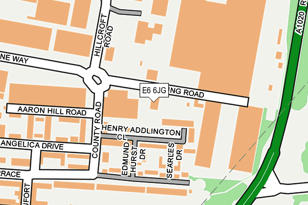
E6 6JG is located in the Beckton electoral ward, within the London borough of Newham and the English Parliamentary constituency of East Ham. The Sub Integrated Care Board (ICB) Location is NHS North East London ICB - A3A8R and the police force is Metropolitan Police. This postcode has been in use since June 1998.


GetTheData
Source: OS OpenMap – Local (Ordnance Survey)
Source: OS VectorMap District (Ordnance Survey)
Licence: Open Government Licence (requires attribution)
| Easting | 543632 |
| Northing | 181774 |
| Latitude | 51.516634 |
| Longitude | 0.068647 |
GetTheData
Source: Open Postcode Geo
Licence: Open Government Licence
| Country | England |
| Postcode District | E6 |
➜ See where E6 is on a map ➜ Where is London? | |
GetTheData
Source: Land Registry Price Paid Data
Licence: Open Government Licence
Elevation or altitude of E6 6JG as distance above sea level:
| Metres | Feet | |
|---|---|---|
| Elevation | 10m | 33ft |
Elevation is measured from the approximate centre of the postcode, to the nearest point on an OS contour line from OS Terrain 50, which has contour spacing of ten vertical metres.
➜ How high above sea level am I? Find the elevation of your current position using your device's GPS.
GetTheData
Source: Open Postcode Elevation
Licence: Open Government Licence
| Ward | Beckton |
| Constituency | East Ham |
GetTheData
Source: ONS Postcode Database
Licence: Open Government Licence
| Windsor Park Estate | Cyprus | 364m |
| East Beckton Sainsbury's (Claps Gate Lane) | Beckton | 524m |
| Beckton Triangle Retail Park (Claps Gate Lane) | Beckton | 537m |
| Horse Leaze (Woolwich Manor Way) | Cyprus | 537m |
| Beckton Triangle Retail Park (Claps Gate Lane) | Beckton | 549m |
| Beckton Dlr Station (Woolwich Manor Road) | Beckton | 560m |
| Gallions Reach Dlr Station (Royal Docks Road) | Gallions Reach | 880m |
| Cyprus Dlr Station (Royal Albert Way) | Cyprus | 965m |
| Beckton Park Dlr Station (Royal Albert Way) | Beckton Park | 1,291m |
| Barking Station | 2.7km |
| Woolwich Arsenal Station | 3km |
| Woolwich Dockyard Station | 3km |
GetTheData
Source: NaPTAN
Licence: Open Government Licence
GetTheData
Source: ONS Postcode Database
Licence: Open Government Licence


➜ Get more ratings from the Food Standards Agency
GetTheData
Source: Food Standards Agency
Licence: FSA terms & conditions
| Last Collection | |||
|---|---|---|---|
| Location | Mon-Fri | Sat | Distance |
| Winsor Terrace | 17:30 | 11:30 | 186m |
| Alpine Way | 454m | ||
| Pearl Close | 17:30 | 11:30 | 687m |
GetTheData
Source: Dracos
Licence: Creative Commons Attribution-ShareAlike
The below table lists the International Territorial Level (ITL) codes (formerly Nomenclature of Territorial Units for Statistics (NUTS) codes) and Local Administrative Units (LAU) codes for E6 6JG:
| ITL 1 Code | Name |
|---|---|
| TLI | London |
| ITL 2 Code | Name |
| TLI4 | Inner London - East |
| ITL 3 Code | Name |
| TLI41 | Hackney and Newham |
| LAU 1 Code | Name |
| E09000025 | Newham |
GetTheData
Source: ONS Postcode Directory
Licence: Open Government Licence
The below table lists the Census Output Area (OA), Lower Layer Super Output Area (LSOA), and Middle Layer Super Output Area (MSOA) for E6 6JG:
| Code | Name | |
|---|---|---|
| OA | E00017627 | |
| LSOA | E01003482 | Newham 033B |
| MSOA | E02000746 | Newham 033 |
GetTheData
Source: ONS Postcode Directory
Licence: Open Government Licence
| E6 6NB | Henry Addlington Close | 56m |
| E6 6NH | County Road | 112m |
| E6 6NE | Searles Drive | 125m |
| E6 6ND | Edmund Hurst Drive | 127m |
| E6 6XD | Roding Road | 130m |
| E6 6LJ | Winsor Terrace | 140m |
| E6 6NL | County Road | 150m |
| E6 6LE | Winsor Terrace | 185m |
| E6 6NS | Angelica Drive | 203m |
| E6 6NJ | Aaron Hill Road | 214m |
GetTheData
Source: Open Postcode Geo; Land Registry Price Paid Data
Licence: Open Government Licence